Download
1 / 52
520 likes | 731 Views
Chapter 13 “Urban Patterns”. Review from Chapter 12 – Define: Urban Rural Urbanization. Largest Cities in the world are now in LDCs Different lifestyle – Rural – know everyone, simple and calmer

E N D
Chapter 13 “Urban Patterns”
Review from Chapter 12 – Define: Urban Rural Urbanization • Largest Cities in the world are now in LDCs • Different lifestyle – Rural – know everyone, simple and calmer • Urban – know family and work mates, complicated, stressful • MSA (CMA) – Metropolitan Statistical Area or Census Metropolitan Area – Urbanized area of influence. Toronto has the GTA. • Micropolitan – smaller urban areas
Percent Urban Population Percent of the population living in urban areas is usually higher in MDCs than in LDCs.
Large Cities Cities with 2 million or more people. Most of the largest cities are now in LDCs.
The next slide contains an illustration of a number of key terms in action in the city of Toronto. Be prepared to take notes.
De-UrbanizationCounter Urbanization Edge Cities – (Satellite Towns) - New Market/Aurora Urban Sprawl Leap Frog – Woodbridge/King City Urban Fringe Steeles Ave. 401, 407, 400 etc are considered Beltways and growth occurs along them Greenbelt HWY 401 Yonge St. Infill – 400 & 401 Spine – University Ave. Light Industry Gentrification Urban Renewal Renovation Density Gradient – Decrease away from CBD Westerlies (Winds) Annexation Zone of Discard Heavy Industry CBD Zone of Assimilation Urban Sprawl Downtown Conurbation Megalopolis Vertical Growth
Social area analysis: • The distribution of social characteristics in a census track may be plotted on a map using GIS. This information creates an overall picture of how various types of people are distributed in an area. Groups do tend to segregate based on income, ethnicity and race. • GIS experts can map: • Social class – income, education, occupation • Age and Martial status • Gender • Race and ethnicity – Chinatowns, Little Italy, Greek town etc. • What kind of decisions can private or public sectors make based on information gathered from above?
Models of Urban Structure: • Concentric Zone Model – 1923 – E.W. Burgess • … • … • … • … • … • … • … • See diagram next slide
Concentric Zone Model Burgess - In the concentric zone model, a city grows in a series of rings surrounding the CBD.
The Sector Model – 1939 – Homer Hoyt • Remember the pattern: • industry next to CBD, workers next to industry, middle class acting as a buffer and then the high class . • … • … • … • … • … • See diagram
Sector Model Hoyt - In the sector model, a city grows in a series of wedges or corridors extending out from the CBD - transportation is key.
The Multi-Nuclei Model – 1945 – C.D. Harris and E.L. Ullman • … • … • … • … • … • … • … • … • See diagram
Multiple Nuclei Model Ullman and Harris - The multiple nuclei model views a city as a collection of individual centers, around which different people and activities cluster.
Does Toronto fit the Concentric model, Sector or Multi-nuclei??
Indianapolis: Percent Renters The distribution of renters in Indianapolis illustrates the concentric zone model.
Indianapolis: Household Income The distribution of high income households in Indianapolis is an example of a sector model.
Indianapolis: Ethnic Patterns The distribution of minorities in Indianapolis is an example of a multiple nuclei model.
Peripheral Model developed by C.D. Harris (same guy who created the Multi-Nuclei Theory) This model relates more to the areas outside the city. … The idea here is that the peripheral areas do not suffer the problems of inner cities – the poor, deterioration, crime, congestion BUT the periphery will suffer from the problems of urban sprawl and segregation (being disconnected from the rest of the city)
Peripheral Model of Urban Areas The central city is surrounded by a ring road, around which are suburban areas and edge cities, shopping malls, office parks, industrial areas, and service complexes.
Using the models outside North America These models do not work well in European cities – The wealthy tend to live in an inner ring next to the center of the city. A Spine (broad avenue) is more prominent in European cities – eg. The Champs-Elysees in Paris The CBD is not necessarily the Geographic center of the city. The Geographic center in European cities is usually the ancient, historical center and the CBD is found outside the city-center – Eg. Rome, Paris and London – these cities even have height restrictions (even Washington D.C. has one) The suburb really does not exist in Europe Single family houses are rare – Condominium living is the norm.
Colonial cites are similar to European cities. Most of these cities are port cities for the obvious reason of supplying the mother country. These cities have pre-colonial parts (old quarters – cramped houses and narrow streets) and European parts (colonial additions – low density, better housing, gardens) The Latin American city stresses the Spine. Where the rich push out from the center. Mexico city is a prime example. See the next slide. Many LDC cities since they cannot handle the growing number of urban residences develop areas where people build make shift homes (no electricity, water or sanitation) on land that does not belong to them – Shanty Towns – Squatter Settlements.
Latin American City Model In many Latin American cities, the wealthy live in the inner city and in a sector extending along a commercial spine.
Discuss the following Inner City Problems: • Filtering • Redlining • Urban Renewal • Public Housing – row housing, town housing • White Flight/Block Busting • Social Problems – inner city schools, poverty, homeless, crime, racial segregation • Ghettoization • Annexation • Gentrification
A word about Urban Renewal: … … … … … … … Toronto – Regent Park Sometimes Urban Renewal leads to Urban Renovation – old properties are not torn down but converted into lofts, galleries, restaurants Toronto – Mill Street district, Yorkville
Problems of the Suburbs: • Importance of the automobile – made suburbs possible - reshaped the city • Density Gradient • Edge Cities • Urban Sprawl • Lack of an infrastructure • Segregation • Zoning • Mass (public) vs. Private Transportation – Rush Hour • Smart Growth/New Urbanism
A word about Urban Sprawl (according to Anthony Downs): • … • … • … • … • … • … • … • … • … • … • … • What effect will the price of gas have on Urban Sprawl? • What is going to happen to the big homes in Woodbridge as the population ages?
Describe the following: Conurbation Megalopolis Examples: BosNyWash, ChiPitts, SanSan, MonTorWin, Tokaido, German Ruhr, Randstad
Suburban Development in the U.S. and U.K. New housing in the U.K. is likely to be in planned new towns, while in the U.S. growth occurs in discontinuous developments.
Private vs. Public Transit Cars Bus Bicycle/Scooters
Montreal’s Metro
Smart Growth – New Urbanism: • A new form of development to fight the negative effects of Urban Sprawl. • Build traditional neighbourhoods, removing the addiction of the car and creating a sense of community. • People not cars • Urban sprawl builds houses first and then everything else – schools, malls, offices are built afterwards to try and catch-up – Smart Growth builds everything at once and it is built to interact. • Schools are built at the center of a residential area connected to the homes with paths • Streets are narrow, each home has a porch, grassy medians in the middle of the street • Commercial and work places are built into the plan – usually on the outskirts of the residences • Housing types are mixed
Walking is encouraged – low order goods within reach • Garages are set to the back of the home or in laneways • Backyard faces into a park or a common area – Front yard is the main focus of the house – spend more time in the front • Main streets will contain major stores and offices • Parks become the nodes • In some plans parks, schools and stores are at the center of the community – this is called a Nodal Design • MUD – Mixed Land-Use Development • Please see the next few slides and the teacher may draw an example on the board.
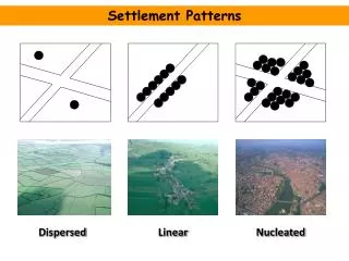
Agglomeration Barriadas Bid-rent theory Blockbusting CBD (central business district) Census tract Centrality Centralization Central-place theory Christaller, Walter City Cityscapes Colonial city Commercialization Commuter zone Concentric zone model Counterurbanization Decentralization Deindustrialization Early cities Economic base (basic/nonbasic) Edge city Emerging cities Employment structure Entrepôt Ethnic neighborhood Favela Female-headed household Festival landscape Gateway city Gender Gentrification Ghetto Globalization Great cities High-tech corridors Hinterland Hydraulic civilization Indigenous city In-filling Informal sector Infrastructure Inner city
Invasion and succession Lateral commuting Medieval cities Megacities Megalopolis/conurbation Metropolitan area Multiple nuclei model Multiplier effect Neighborhood Office park Peak land value intersection Planned communities Postindustrial city Postmodern urban landscape Primate city Racial steering Rank-size rule Redlining Restrictive covenants Sector model Segregation Settlement form (nucleated, dispersed, elongated) Shopping mall Site/situation Slum Social structure Specialization Squatter settlement Street pattern (grid, dendritic; access, control) Suburb Suburbanization Symbolic landscape Tenement Threshold/range Town Underclass Underemployment Urban growth rate