Download
1 / 2
20 likes | 144 Views
Mess-Transekte ( optional ). Mess-Stationen. ( MARNET und FINO). Hilfspunkt, optionale Messstation. Transekt OW1 56.3,23.8,48.9km von Nordsee1 bis List Transekt OW2 84.6,23.6,50.7,37.8km auf 54°40.8'N von Nordsee5 bis Amrum Transekt OW3 74.3,(28.1,24.9)

E N D
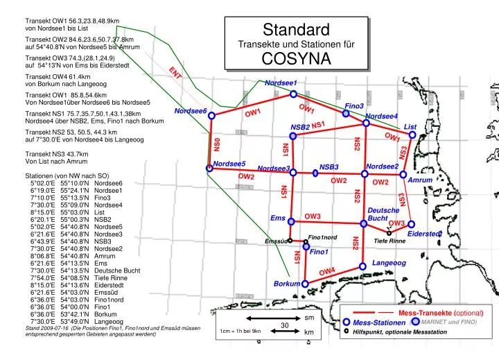
Mess-Transekte (optional) Mess-Stationen ( MARNET und FINO) Hilfspunkt, optionale Messstation Transekt OW1 56.3,23.8,48.9km von Nordsee1 bis List Transekt OW2 84.6,23.6,50.7,37.8km auf 54°40.8'N von Nordsee5 bis Amrum Transekt OW3 74.3,(28.1,24.9) auf 54°13'N von Ems bis Eiderstedt Transekt OW4 61.4km von Borkum nach Langeoog Transekt OW1 85.8,54.6km Von Nordsee1über Nordsee6 bis Nordsee5 Transekt NS1 75.7,35.7,50.1,43.1,38km Nordsee4 über NSB2, Ems, Fino1 nach Borkum Transekt NS2 53, 50.5, 44.3 km auf 7°30.0'E von Nordsee4 bis Langeoog Transekt NS3 43.7km Von List nach Amrum Stationen (von NW nach SO) 5°02.0'E 55°10.0'N Nordsee6 6°19.0'E 55°24.1'N Nordsee1 7°10.0'E 55°13.5'N Fino3 7°30.0'E 55°09.0'N Nordsee4 8°15.0'E 55°03.0'N List 6°20.1'E 55°00.3'N NSB2 5°02.0'E 54°40.8'N Nordsee5 6°21.6'E 54°40.8'N Nordsee3 6°43.9'E 54°40.8'N NSB3 7°30.0'E 54°40.8'N Nordsee2 8°06.8'E 54°40.8'N Amrum 6°21.6'E 54°13.5'N Ems 7°30.0'E 54°13.5'N Deutsche Bucht 7°54.0'E 54°08.5'N Tiefe Rinne 8°15.0'E 54°13.6'N Eiderstedt 6°21.6'E 54°03.0'N Emssüd 6°36.0'E 54°03.0'N Fino1nord 6°36.0'E 54°00.0'N Fino1 6°36.0'E 53°42.1'N Borkum 7°30.0'E 53°49.0'N Langeoog Stand 2009-07-16 (Die Positionen Fino1, Fino1nord und Emssüd müssen entsprechend gesperrten Gebieten angepasst werdent) Standard Transekte und Stationen für COSYNA ENT Nordsee1 Fino3 OW1 Nordsee6 OW1 Nordsee4 NS1 List NSB2 NS0 OW1 NS2 NS1 NS3 Nordsee5 Nordsee2 NSB3 Nordsee3 OW2 Amrum OW2 OW2 NS1 NS2 NS3 Deutsche Bucht OW3 Ems OW3 Eiderstedt Fino1nord NS2 Tiefe Rinne Emssüd Fino1 NS1 Langeoog OW4 Borkum sm 30 1cm = 1h bei 9kn km Position x5,03 y-0,61cm Höhe 19,50
Empfehlung zur Abfahrt der Transekten und Stationen Es ist sinnvoll mit der Station Ems oder Eiderstedt zu beginnen oder zu enden, weil dann keine Strecke doppelt befahren werden muss. Eine mögliche Fahrroute: Ems, Nordsee3, NSB2, Nordsee4, Fino3, Nordsee6, Nordsee5, Nordsee3, NSB3, Nordsee2, Amrum, List, Nordsee4, Nordsee2, Deutsche Bucht, Langeoog, Borkum, Fino1, Ems, Deutsche Bucht, Eiderstedt Kreuzungspunkte, die zweimal angefahren werden, können bei Bedarf zB nachts ohne Station überfahren werden. Die Strecke Eiderstedt Amrum ist optional, so dass der Anfangs-bzw. Endpunkt statt Eiderstedt dann Amrum wäre.