Download
1 / 16
160 likes | 274 Views
Performance of hi-res GFS-based NOAA models v ECMWF 2013 HFIP summer demo – WPAC Mike Fiorino Commander US Navy (retired) NOAA ESRL Boulder CO 08 JAN 14. Prelims – NBs – ROEs. verify against working best track using NHC/JTWC rules – if it’s a TC – verify

E N D
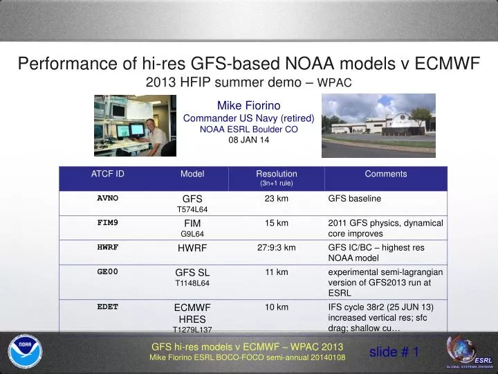
Performance of hi-res GFS-based NOAA modelsv ECMWF 2013 HFIP summer demo – WPACMike FiorinoCommander US Navy (retired)NOAA ESRL Boulder CO08 JAN 14
Prelims – NBs – ROEs • verify against working best trackusing NHC/JTWC rules – if it’s a TC – verify • option to filter out over-land TC posits • option to filter out TC posits NOT in a WARNING/ADVISORY status • more frequent in WPAC than LANT • EDET comes from ECMWF (tigge or bufr) • ECWMF tracker using full res fields – has a few issues • intensity forecasts have less bias compared to trackers using 1deg fields (e.g., EMX) • tracking for GFS/FIM9/GFS-SL uses 0.5 deg global fields – will not completely resolve model TC intensity • emphasize modelperformance vice performance as a forecast aid • will not compare to OFCL or other ‘late’ aids such as TVCN • homogeneous comps – every 12 h vice 06 h because HRES runs 00/12UTC • 12-h run separation ~ e-folding time for run-to-run error correlation • USN talk: tau = forecast time (h) ; phonetic alphabet for subbasins • all analysis and plots done with python+opengrads using dictionaries of python ‘vdeck’ and ‘mdeck’ objects (http://sourceforge.net/projects/wxmap2/)
review of the WPAC seasonhttp://ruc.noaa.gov/hfip/tcactslow start but active oct-nov ; ACE ~ -7% of normal 33 # storms – 5 STY – 12 RI – 7 ED
15-d sfc wind anomaliesNCEP R1 30-y daily climo (streams) v GFS mean analysis 091400-092900 (color anomWindSpeed; barb anom wind) 2013 monsoon trough anomalously strong and shifted poleward climo position of monsoon trough
WPAC 2013 oddities – 30Wtransited three subbasins W—B—A JTWC WPAC warnings 110306-110606 dissipates in Arabian Sea JTWC BB warnings 111506 -111606
WPAC 2013 oddities part 2 – 02B & 05Bstarted in WPAC (gulf of Thailand) dissipates in Arabian Sea 02B STC Phailin (ED) 100412-101400 05B TC Lehar (RW) 111918-112000
WPAC 2013 – forecast error • HWRF fastesterror growth • FIM9 slowesterror growth • FIM9 most competitive with ECMWF • errors are ‘off the charts’ compared to CLIPER (C120) • big impact of only verifying WARN posits
WPAC 2013 – intensity error • HWRF almost NO bias (mean error)!! • ECMWF has highest initial intensity error; HWRF almost none • as in the LANT, ECMWF bias decreases in time… • higher res in FIM9 (15 km) results in smaller bias than the GFS at the later taus, but signal is reduced by using 0.5 deg grids • HWRF has higher abs mean error (‘intensity error’) in WPAC (17 kt) v LANT (~10kt)
Intensity v Forecast ErrorWPAC cases of extremely large ECMWF HRES intensity errors 104 kt Intensity error!!!
Intensity v Forecast ErrorWPAC cases of extremely large ECMWF HRES intensity errors HWRF excellent Vmax forecast ECMWF flat-lined ECMWF tracker issue?
by storm tau0 & tau72 intensity error tau 0 17-33W tau 0 01-16W tau 72 17-33W tau 72 01-16W
WPAC 2013 model (ECMWF) forecast intensity error storms of shame 2013 07W TY SOULIK :125 : 7.2; 9.2 : 22.4 135.6 : 070512<->071418 : 19.1<->31.7 :116.7<->158.0 : 8.3 :11.4 : 9: 2: 5:ddED :tG: 54 9X: 92W 1st: 070718 2013 11W STY UTOR :130 : 9.2;10.2 : 18.3 120.8 : 080712<->081718 : 12.0<->25.9 :109.1<->138.6 : 8.4 :10.5 : 8: 1: 7:ddED :tG: 30 9X: 96W 1st: 080818 2013 17W STY USAGI :140 : 6.8; 8.2 : 19.5 124.9 : 091506<->092312 : 17.0<->25.4 :110.2<->132.6 : 9.0 :14.4 : 6: 4: 6:ddED :tG: 36 9X: 99W 1st: 091618 2013 23W TY DANAS :125 : 5.2; 7.5 : 21.3 140.6 : 100100<->100818 : 15.9<->36.0 :126.9<->151.5 : 5.9 : 7.7 : 6: 0: 4:ddRI :tG: 54 9X: 97W 1st: 100312 2013 28W STY LEKIMA :140 : 6.2; 7.8 : 18.8 155.0 : 101818<->102612 : 9.3<->39.5 :144.3<->169.0 : 8.9 :15.6 : 8: 4: 4:ddED :tG: 42 9X: 95W 1st: 102012 2013 31W STY HAIYAN :170 : 8.8;10.8 : 10.9 134.5 : 110106<->111200 : 5.4<->24.7 :107.2<->164.2 :11.3 :21.6 : 7: 4:11:ddED :tG: 48 9X: 99W 1st: 110306 17W – STY USAGI (うさぎ= rabbit) (ED) 07W – almostSTY LEKIMA (ED) 11W – STY UTOR (ED) land TC points land TC points 31W – STY HAIYAN (ED) 28W – STY LEKIMA (ED) 23W – almostSTY DANAS (RI) land TC points
WPAC 2013 intensity error for BIG ECMWF intensity error storms07W, 11W, 17W, 23W, 28W, 31W • HWRF clear winner with a weak bias (as expected for STYs) • huge ECMWF initial intensity error – poor inner-core TC analysis • other global models about the same, except initially
WPAC 2013 forecast error for BIG ECMWF intensity error storms07W, 11W, 17W, 22W, 28W, 31W • superior HWRF intensity errors do NOT translate into better track forecasts • errors lower than for all storms – well-behaved STYs
WPAC 2013 forecast error – HWRF v GFS v ECMWFALL storms v BIG IE v NON-BIG IE • ECMWF errors almost identical tau0-72 between BIG and non-BIG IE storms…not true for HWRF/GFS…
Takeaways • case selection has big impact on mean forecast errors • ECMWF had dreadful intensity errors in WPAC – they have a serious TC analysis issue – but impact on track was weak (Fiorino and Elsberry 1989) but detectible?