Download
1 / 17
170 likes | 279 Views
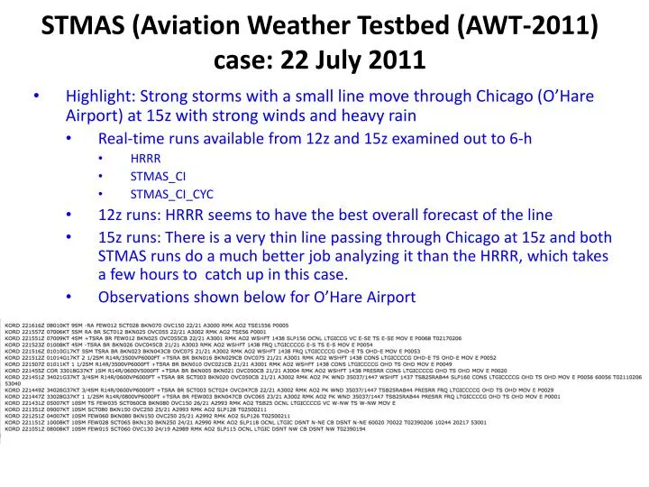
STMAS (Aviation Weather Testbed ( AWT-2011) case: 22 July 2011. Highlight: Strong storms with a small line move through Chicago (O’Hare Airport) at 15z with strong winds and heavy rain Real-time runs available from 12z and 15z examined out to 6-h HRRR STMAS_CI STMAS_CI_CYC

E N D
STMAS (Aviation Weather Testbed(AWT-2011) case: 22 July 2011 Highlight: Strong storms with a small line move through Chicago (O’Hare Airport) at 15z with strong winds and heavy rain Real-time runs available from 12z and 15z examined out to 6-h HRRR STMAS_CI STMAS_CI_CYC 12z runs: HRRR seems to have the best overall forecast of the line 15z runs: There is a very thin line passing through Chicago at 15z and both STMAS runs do a much better job analyzing it than the HRRR, which takes a few hours to catch up in this case. Observations shown below for O’Hare Airport
SPC Outlooks and reports for 22 July 2011 SPC severe reports through 1910z on 22 July SPC Convective Outlook issued at 06z/22 July SPC Convective Outlook issued at 13z/22 July
1200 UTC 22 July run – analyses of composite reflectivity HRRR STMAS_CI run The initial analysis is very good for both STMAS models. Observed: NOWRAD with obs STMAS_CI_CYC run
1200 UTC 22 July run – 1-h valid 13z/composite reflectivity HRRR There are differences between the 2 STMAS runs, with larger echoes in the CI run. STMAS seems to be a little fast moving cells eastward across southern MI. STMAS_CI run Observed: NOWRAD with obs STMAS_CI_CYC run
1200 UTC 22 July run – 2-h valid 14z/composite reflectivity HRRR Maybe it is a boundary problem for STMAS, but the HRRR has echoes trailing west past northern IL, like what is observed, but the STMAS runs do not. The actual line approaching Chicago (end of the arrow) is not shown by any model well enough in its southern extent. STMAS_CI run Observed: NOWRAD with obs STMAS_CI_CYC run
1200 UTC 22 July run – 3-h valid 15z/composite reflectivity HRRR The line is roaring through Chicago (end of the arrow) at this time, and again none of the model has enough southern extent. The STMAS_CI run does have more of a line than certainly the CYC run and even the HRRR, it just does not extend quite far enough south. There is no echo in WV (where the HRRR has a cell) though some are starting to develop farther south STMAS_CI run Observed: NOWRAD with obs STMAS_CI_CYC run
1200 UTC 22 July run – 4-h valid 16z/composite reflectivity HRRR The NOWRAD suggests a bit of weakening which is also shown in all the models. The southern extent of the actual line is still not captured in the forecasts. It looks like there is a low-level reflectivity fine line that might be a gust front in the STMAS runs (?), marked by the yellow arrow. STMAS_CI run Observed: NOWRAD with obs STMAS_CI_CYC run
1200 UTC 22 July run – 5-h valid 17z/composite reflectivity HRRR The HRRR is now developing a line with a southward extent (yellow arrow) that is in about the right place as where the original line is now found. The 2 STMAS runs seem to also be organizing a line (yellow arrow) but it is too far east, although there are other cells forming into OH east of the line. STMAS_CI run Observed: NOWRAD with obs STMAS_CI_CYC run
1200 UTC 22 July run – 6-h valid 18z/composite reflectivity HRRR The HRRR now has a very good forecast, even though it missed the line when it passed through Chicago near 15z. As before, the STMAS runs do not show the line, but a complex farther east. They two STMAS runs look similar to each other. STMAS_CI run Observed: NOWRAD with obs STMAS_CI_CYC run
SPC Outlooks and reports for 22 July 2011 SPC severe reports through 22z on 22 July SPC Convective Outlook issued at 13z/22 July SPC Convective Outlook issued at 20z/22 July
1500 UTC 22 July run – Analyses (0-h) composite reflectivity HRRR The line is roaring through Chicago (end of the arrow) at this time, and this thin line of storms (to the south of Chicago) is better captured at 0h in the STMAS runs. STMAS_CI run Observed: NOWRAD with obs STMAS_CI_CYC run
1500 UTC 22 July run – 1-h valid 16z/composite reflectivity HRRR The 2 STMAS runs have a better handle on the southward extent of the line from Chicago south than does the HRRR at 1-h into the forecast. STMAS_CI run Observed: NOWRAD with obs STMAS_CI_CYC run
1500 UTC 22 July run – 2-h valid 17z/composite reflectivity HRRR The line is far stronger in the 2 STMAS runs (maybe too strong?) compared to the HRRR, which is trying to form a line that is a little too far east. STMAS_CI run Observed: NOWRAD with obs STMAS_CI_CYC run
1500 UTC 22 July run – 3-h valid 18z/composite reflectivity HRRR The line (yellow arrow) is forming up better in the HRRR, perhaps bowing out a bit too much. The STMAS_CI run looks to be a little stronger than the CYC run, although the CYC run has more echoes forming farther east of the line. STMAS_CI run Observed: NOWRAD with obs STMAS_CI_CYC run
1500 UTC 22 July run – 4-h valid 19z/composite reflectivity HRRR The line (yellow arrow) looks similar in the HRRR and STMAS_CI, and both seem to be bowing it out more than the observed line, which seems to be weakening (although station KAOH in nw OH (located at the end of the white arrow) has a gust to 60 kts at 2007. The CI run remains stronger with the line than the CYC run. STMAS_CI run Observed: NOWRAD with obs STMAS_CI_CYC run
1500 UTC 22 July run – 5-h valid 20z/composite reflectivity HRRR Again the line (yellow arrow) looks similar in the HRRR and STMAS_CI. It seems to be a little more organized in the observations as well. Fairly big difference between the STMAS_CI_CYC run and the other two runs in terms of the line. STMAS_CI run Observed: NOWRAD with obs STMAS_CI_CYC run
1500 UTC 22 July run – 6-h valid 21z/composite reflectivity HRRR At this point tricky to argue which forecast is best. The line (yellow arrow) does not extend as far back into IN as the 2 STMAS models show, and now the somewhat weaker STMAS_CI_CYC run might be the better of the two STMAS runs. STMAS_CI run Observed: NOWRAD with obs STMAS_CI_CYC run