Download
1 / 14
140 likes | 290 Views
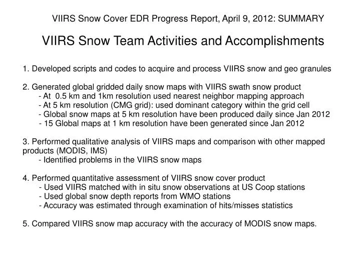
VIIRS Snow Cover EDR Progress Report, April 9, 2012: SUMMARY VIIRS Snow Team Activities and Accomplishments. 1. Developed scripts and codes to acquire and process VIIRS snow and geo granules 2. Generated global gridded daily snow maps with VIIRS swath snow product

E N D
VIIRS Snow Cover EDR Progress Report, April 9, 2012: SUMMARY VIIRS Snow Team Activities and Accomplishments 1. Developed scripts and codes to acquire and process VIIRS snow and geo granules 2. Generated global gridded daily snow maps with VIIRS swath snow product - At 0.5 km and 1km resolution used nearest neighbor mapping approach - At 5 km resolution (CMG grid): used dominant category within the grid cell - Global snow maps at 5 km resolution have been produced daily since Jan 2012 - 15 Global maps at 1 km resolution have been generated since Jan 2012 3. Performed qualitative analysis of VIIRS maps and comparison with other mapped products (MODIS, IMS) - Identified problems in the VIIRS snow maps4. Performed quantitative assessment of VIIRS snow cover product - Used VIIRS matched with in situ snow observations at US Coop stations - Used global snow depth reports from WMO stations - Accuracy was estimated through examination of hits/misses statistics 5. Compared VIIRS snow map accuracy with the accuracy of MODIS snow maps.
Global gridded VIIRS snow map: overall realistic characterization of the global snow cover VIIRS snow cover product at 0.5 km spatial Feb 22, 2012 Snow Land 20 km Cloud
Global gridded VIIRS snow map: Detailed characterization of regional snow cover at high spatial resolution Feb 22, 2012 Snow Land 20 km Cloud 0.5 km spatial resolution
However closer analysis reveals frequent snow misses (omission errors) in densely forested areas Example of snow misses in the boreal forest zone in Canada. Jan 20, 2012 Area size:~ 400 x 700 km Classification results: Water: 5.2% Cloud: 5.4% Land: 6.4% (errors !) Snow: 83.0% However the area is completely snow-covered. The rate of snow omission errors in clear sky land pixels is 7.1%. Snow Land Cloud
Snow commission errors are frequent and easily seen in tropical areas Commission errors occur due to the confusion of clouds with snow cover Jan 20, 2012 Area size: ~ 800 x 1200 km Classification results: Water: 10.2% Cloud: 82.8% Land: 6.6% Snow: 0.4% (errors !) However the area is completely snow-free. The rate of snow commission errors in clear sky land pixels is 5.7% Snow Land Cloud
VIIRS snow misses are more likely for observations made in the backscatter geometry IMS analysts do no see any gaps in the snow cover in this region NOAA IMS Interactive Snow Map March 2, 2012 Snow Backscatter Land Forward scatter Cloud Sun-satellite relative azimuth Snow is more often missed at the edge of the scan in the backscatter portion of the swath. These misses typically occur over densely forested areas.
VIIRS misses more snow than MODIS IMS analysts do no see any gaps in the snow cover in this region NOAA IMS Interactive Snow Map VIIRS Snow Map March 2, 2012 Example of substantial snow misses in the VIIRS map (above). Snow misses are much smaller in the MODIS product (right). However MODIS labels more pixels as “cloudy” MODIS Aqua Snow Map March 2, 2012
VIIRS vs in situ observations at US COOP stations: 85-90% agreement Statistics of VIIRS clear sky snow retrievals matched with observations at US Coop stations. Statistics was produced using VIIRS snow cover maps at 1 km and 5 km spatial resolution. • VIIRS clear sky retrievals were matched with data from US Coop stations • 400 to 900 comparisons daily, CONUS area • Better accuracy for 5 km grid cells since 5km grid cells with over 50% cloud cover were labeled as “cloudy” and were excluded from the accuracy analysis
VIIRS vs in situ snow: Error budget Error statistics for VIIRS clear snow retrievals as compared with observations at US Coop stations Gridded snow cover maps at 1 km resolution were used - Disagreement between VIIRS and snow depth reports is largely due to snow misses in the VIIRS product.
VIIRS snow vs in situ snow at WMO stations Probability of correct snow identification (PCSI) in the VIIRS snow product (Nsnow_hits/(Nsnow_hits+Nsnow_misses) Location of WMO stations used in the validation Reports from over 2000 stations around the globe have been processed daily PCSI ranges mostly within 0.8 to 0.9 Year 2012
VIIRS vs NOAA Interactive charts: 90-95% agreement on snow cover distribution IMS snow/ice map • VIIRS 1km resolution gridded snow maps compared with IMS daily snow cover • VIIRS clear sky retrievals between 30N and 70N are only used • 90-95% agreement of VIIRS snow maps to IMS (Northern Hemisphere) • Similar accuracies over North America and Eurasia • Most disagreement is due to omission errors (snow misses) in the VIIRS product.
VIIRS vs MODIS snow: MODIS looks better so far • MODIS and VIIRS gridded snow maps vs in situ observations • 400 to 900 comparisons daily • CONUS area • MODIS and VIIRS vs IMS maps • Northern Hemisphere • 30N-70N area
Conclusions 1. VIIRS snow maps provide a generally realistic characterization ofthe global snow extent on a daily basis. VIIRS high spatial resolution allows for reproducing small details in the snow cover spatial distribution. 2. Most problems are associated with - Snow misses in dense forests. Misses increase in the backscatter geometry - Missed clouds and hence false snow identification in areas of high cloud amount - Low solar elevation and cloud shadows may be a contributing factor3. Agreement of gridded snow retrievals at 1 km resolution to surface observations - 85-90% in the middle of winter (Jan-Feb) - 86-93% in March (since there was no snow at most stations) - Omission errors are ~2-5 times more frequent than commission errors - Quantitative assessment is performed over the Northern part of CONUS area4. Aggregating VIIRS data in larger, 5 km grid cells improves the agreement by up to 5% 5. The accuracy of VIIRS 5 km resolution snow maps is ~1.5-4% below theaccuracy of corresponding MODIS snow maps - This means that VIIRS snow maps contain ~15-40% more errors than MODIS.
Potential Improvements and Future Work Potential Improvements 1. Adjust threshold values of the tests in the current algorithm to improve its performance over forested areas - A better way would be to introduce threshold values for the NDVI, NDSI and the visible reflectance test that depend on solar-satellite observation geometry 2. Use snow cover climatology to eliminate at least some obvious false snow identifications in the tropical and equatorial areas 3. In the gridding procedure give preference to observations taken in the forward scatter plane. Future Work 1. Continue qualitative and quantitative examination of VIIRS snow retrievals 2. Set up and launch a system for routine evaluation of the VIIRS snow algorithm performance. 3. Modify and improve the algorithm