Download
1 / 62
640 likes | 873 Views
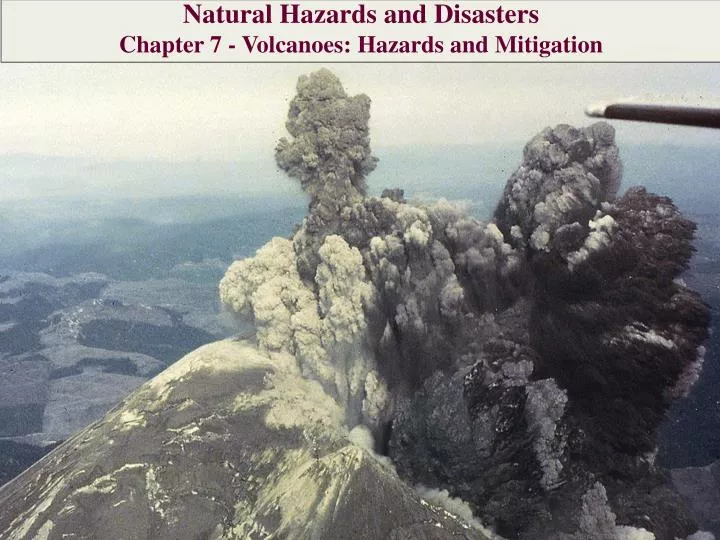
Natural Hazards and Disasters Chapter 7 - Volcanoes : Hazards and Mitigation. Mount St. Helens Erupts. May 18, 1980: few people camping or logging in restricted zone north and west of Mount St. Helens

E N D
Natural Hazards and Disasters Chapter 7 - Volcanoes: Hazards and Mitigation
Mount St. Helens Erupts May 18, 1980: few people camping or logging in restricted zone north and west of Mount St. Helens 8:32 am: Dr. David Johnston was lone volcanologist stationed on high ridge facing volcano (last minute replacement at post for someone else) when he radioed Cascades Volcano Observatory
Mount St. Helens Erupts “Vancouver, Vancouver, this is it!” Johnston’s last words before being swept away by the lateral blast Survivors’ eyewitness accounts describe black, boiling clouds of pyroclastic flows Some people trapped and burned, many did not survive Geologist Dr. David Johnston detoured on way home from conference for quick flight around volcano, just as eruption began – captured impressive photos of landslide and lateral blast
Volcanic Hazards • Millions of people around world live in risk of volcanic hazard • Volcanic materials give rich, fertile soil for agriculture • Majestic volcanic peaks give beautiful vistas • Hawaiian climate appeals to retirees • Most volcanic eruptions kill no more than few hundred people • Few volcanic eruptions have potential to kill many more, depending on how many people live in close proximity
Lava Flows • Flowing basalt lava may cool, blacken on outside, but still be hot enough to ignite wood structures • Objects that aren’t burned may be surrounded or buried by flow • Engulfed trees rot away and leave behind cast • Although incredibly destructive, lava flows move so slowly and cover small enough area that they pose little threat to human life • Rare, fluid, alkali-rich lava flows faster – from Vesuvius, killed 3,000 people in 1631 • Basaltic magma very rarely contains enough gas to blast out in Plinian eruption
Pyroclastic Flows and Surges • Mixture of hot volcanic ash and steam that flows downhill because too dense to rise • Also called ash flow, nueeardente, glowing avalanche, ignimbrite deposit • Race down side of volcano at 50-200 kph (30-120 mph) • Form as part of eruption column collapse • Ash-rich, shock wave surge may race ahead of pyroclastic flow, up to 750 kph (~450 mph) • Pyroclastic flow means certain death unless near edges, in building or vehicle • Hottest pyroclastic flows glow at 800-850oC, hot enough to fuse into solid mass, welded ash
Pyroclastic Flows and Surges Most dangerous place: bottom of valley Can approximate travel distance of pyroclastic flow with energy line sloping downward from top of ash-rich part of eruption column Actual hazard distance can be much greater if eruption is fueled by lateral blast Pyroclastic flows can travel over surface of water
Feb. 25th, 2011 Pyroclastic flows are some of the most fearsome hazards posed by erupting volcanoes. These avalanches of superheated ash, gas, and rock are responsible for some of the most famous volcanic disasters in history: the burial of the Roman city of Pompei, and the destruction of Saint-Pierre in 1902. More recently, pyroclastic flows from Mount Merapi in Indonesia caused most of the casualties during the volcano’s 2010 eruption. The intense heat [over 1,000°Celsius (1800°Fahrenheit)], terrific speed [up to 720 kilometers (450 miles) per hour], and mixture of toxic gases all contribute to the deadly potential of pyroclastic flows. This false-color satellite image shows the remnants of a large pyroclastic flow on the slopes of Shiveluch Volcano. A NASA satellite detected heat from the flowduring or shortly after the event on the night of January 25, 2011. Fortunately, no one was hurt in the sparsely-populated area. Dark deposits covering over 10 square kilometers (4 square miles) were still visible a month later on February 25, when this image was acquired. Both images were collected by the Advanced Spaceborne Thermal Emission and Reflection Radiometer (ASTER) aboard the Terra satellite. Light brown ash covers the snow above the flow deposits, and a tiny plume rises from Shiveluch’s growing lava dome. Vegetation surrounding the volcano is colored dark red. http://earthobservatory.nasa.gov/NaturalHazards/view.php?id=49468
Ash and Pumice Falls • Volcanic ash is composed of bits of pumice • Ash particles are suspended in cloud of steam that cools and condenses, falls in ashy rain (volcano weather) • Largest ash particles fall near vent • Smallest ash particles remain suspended in stratosphere for years, and are carried around world, blocking radiation from sun • After 1815 eruption of Mount Tambora, Indonesia: “year without a summer”
Ash and Pumice Falls • Heavy loading of ash on roofs, when mixed with water, causes roof collapse • Serious health problems from inhaling ash for those with existing respiratory illness • Problems for cars: hinders visibility, clogs air filters • Serious problems for aircraft: causes loss of jet engine power, damage to engines • Cases of dramatic drops by planes that flew into ash clouds, before restarting engines • Monitoring systems near active volcanoes now warn of potential danger, but radar can not detect ash clouds
Volcanic Mudflows Ash combines with water, pours down sides of stratovolcanoes at high speeds, consistency of wet concrete Velocities similar to deep floodwaters, spread over lower slopes, picking up objects in path Can be triggered by eruption of volcano covered in ice or snow, or by heavy rain
Volcanic Mudflows Icy to boiling temperatures (hot mudflow called lahar) Most stratovolcanoes emit steam from summit, from snow or rain meltwater heated by volcano’s hot interior Hot groundwater further weakens already unstable stratovolcano, making enormous mudflows more likely Mudflows from Mount Rainier have buried valleys where many communities now sit
Poisonous Gases At depths of more than few kilometers, pressure keeps gas dissolved in magma At surface, gases exsolve (come out of solution) Increasing volume of escaping gases near volcano can warn of impending eruption Gas in atmosphere forms aerosols volcanic smog, vog
Poisonous Gases • Carbon dioxide in high concentrations is colorless, odorless, denser than air (hugs ground) and deadly • 1986 in Cameroon: magmatic carbon dioxide bubbled out of Lake Nyos, swept downhill through several villages as river 50 m thick, 16 km long • Killed more than 1,700 people, 3,000 cattle, small animals
Poisonous Gases Carbon dioxide from Long Valley Caldera in eastern California has killed huge areas of trees Other volcanic gases include sulfur dioxide, hydrogen sulfide, chlorine compounds, fluorine
Predicting Eruptions Best protection from volcanic hazard is advance prediction Evacuate population, take other precautions Volcanologists use historical records to assess long-term prospects of volcanic activity in specific location Also use short-term indications of impending eruption
Examining Ancient Eruptions Areas such as Italy, Japan have long historical records of eruptions, but most areas do not Volcanoes that only erupt once or twice in 10,000 years may not be described in historical record Paleovolcanology interprets deposits from prehistoric eruptions, reconstructs record from age dates (plants charred in eruptions or rocks) Eruptive products include lavas, pyroclastic flows, ash-fall deposits, mudflows (called tuff as rock) Determine magnitude, sequence, timing of past eruptions
Examining Ancient Eruptions • Erosion of volcanic slopes removes evidence • Are various layers part of different eruptions or single eruptive sequence? • Volcanoes can still be active even if dormant for long period of time • Intervals between caldera eruptions (such as Yellowstone) can be hundreds of thousands of years • Scientists must watch for short-term indications of impending eruption
Eruption Warnings: Volcanic Precursors Seismograph records used to infer magma movement underground Harmonic tremor: low-frequency rolling ground movement that precedes many eruptions Small earthquakes may become more frequent, move up toward summit Some eruptions are not preceded by change in earthquake activity Increase in earthquake activity may not be followed by major eruption
Eruption Warnings: Volcanic Precursors • Change in surface temperature, amount of steam emitted may be indication of eruption • Observed temperature changes may be volcanic or extraneous • Small changes in summit elevations or slope steepness can be observed by lasers of tiltmeters • Satellite-based Global Positioning System (GPS) also detects changes in position
Eruption Warnings: Volcanic Precursors • Change in gas emissions may be precursor: increase in sulfur or sulfur-to-chlorine ratio • Prediction of impending eruption is made when scientists are reasonably sure of threat • Prediction is only useful to extent that authorities act on it • Many people resent effects of prediction on personal freedom – fight closures, sneak past barriers
Mitigation of Damage Not always possible to predict volcanic eruptions Varying degrees of success with strategies for mitigating volcanic damage
Controlling Lava Flows • Attempts to slow or divert lava flows have had only partial success • Most effective approach is to cool and solidify front of flow with water • Large flow approaching Heimaey, Iceland was cooled, slowed and partly diverted with water from fire hoses • Flows from Mauna Loa were diverted by bombing in 1935, 1942; by barriers in 1960
Warning of Mudflows Automatic detection systems could provide enough warning for people to evacuate to higher ground in valleys below volcanoes Warning systems can use temperature sensors or vibration sensors to detect mudflow Time to evacuate may be only 30 minutes (Orting, Washington near Mount Rainier)
Populations at Risk • Can now provide some warning of impending eruption • Always risk false alarm, destruction of credibility • Social, economic consequences of needless evacuation of hundreds of thousands of people • Examples of how scientists assess risk, disaster planning and preparedness • Mount Vesuvius region of Italy • Cascades Range of North America
Vesuvius and Its Neighbors • 700,000 people live in potentially fatal zone of Vesuvius • Roads, rails crowded beyond capacity on normal days • Northeastern part of African plate subducts under southern Europe • Collision raises Alps, feeds volcanoes in Italy and eastern Mediterranean • Volcanoes have devastated populations, destroyed ancient civilizations
Mount Vesuvius • Naples (population 3 million) sits between Mount Vesuvius and Campi Flegrei • Vesuvius goes through cycles of volcanic destruction and rebuilding of volcano • Pyroclastic flows in 3580 BC covered area of Naples • Eruptions in 79 AD buried Pompeii and Herculaneum, killing 4000 of 20000 residents • Development continues today • Vesuvius could erupt anytime, after 60 years of inactivity
Mount Vesuvius Molten magma exists 5-10 km below crater Next eruption could be largest since 1631, or might resemble eruptions of 1906 and 1944 Pyroclastic flows at more than 100 km/hr, temperature of 1000oC would reach populated areas in 5-7 minutes Eruption like that of 79 AD would now kill several hundred thousand to few million people 1996 eruption contingency plan assumes warning of 2 weeks, with 600,000 people evacuated in one week
Campi Flegrei Active resurgent caldera in Naples’ western suburbs Two million people live on caldera floor Numerous eruptive periods in last 39,000 years, since formation of caldera Swelling and subsiding magma under area continues Past eruptions dumped 1 m of ash on area
The Cascades of Western North America Stratovolcanoes of Cascade Range lie over active subduction zone, inland from oceanic trench (filled with sediment, not easily apparent) Investigations revealed that chain is far more active than previously supposed Future large eruptions should not be surprising Risk to human life and property in Cascades is limited by lack of proximity to large cities, some warning time for evacuation Hazard is compounded by westerly winds, heavy moisture from Pacific – increases mudflow risk
Mount Rainier • Largest, highest, spectacular Cascade Range volcano • Dominates skyline of western Washington, including Seattle and Tacoma • Most dangerous because of large population close to base • National park status has limited very close development • Last eruption in 1840s • Eruption could dump heavy ash on cities downwind • Several small towns within range of pyroclastic flows or mudflows • Mudflows could form without volcanic eruption or warning
Mount St. Helens • In 1980, Mount St. Helens known to be most active, most likely to erupt in Cascades • May 18 eruption was one of most closely observed and studied volcanic events at time • Had been quiet since 1843 dacite dome formation and pyroclastic flows, 1857 andesite lava flows • Hazard forecasts were issued two years before 1980 blast by U.S. Geological Survey • Generally accurate, though understated • Did not predict specific eruption times or dictate areas to close – public policy decisions beyond its authority
Mount Hood • Dominates skyline of Portland, Oregon • Last eruption in 1790s • Several small towns within range of pyroclastic flows or mudflows • Mudflows could form without volcanic eruption or warning, flow toward Portland • Next eruption would probably be preceded by swarms of small earthquakes, dark steam clouds
Three Sisters • Spectacular trio of volcanic cones west of Bend, Oregon • Faith, Hope and Charity • In March, 2001, satellite radar interferometry discovered low, broad bulge, suggesting magma chamber 5-6 km below surface • Followed by recent earthquakes • Could be catastrophic for Bend, Oregon with population of 60,000
Mount Mazama (Crater Lake) Was enormous, andesite volcano until 7,700 years ago Destroyed itself in gigantic rhyolitic eruption followed by ground surface collapse into emptied magma chamber, forming caldera depression – now filled with water, Crater Lake Extending edges of Crater Lake upward indicates mountain as big as Mount Shasta 1000 years ago new cinder cone emerged in caldera basin – Wizard Island
Mount Shasta • French crew sailing past northern California in 1786 reported volcano in eruption, presumed to be Mount Shasta • Second highest of Cascade Range volcanoes, hovers over northern California • Underlain by shallow magma chamber • Ready to erupt monstrous amount of rhyolite ash or lava • Enormous landslides from unstable mountain have occurred in past, could occur again
Mount Lassen • Grossly oversized lava dome of dacite, from long heritage of volcanic violence • Formed from wreckage of Tehama – large, andesitic volcano that sank into caldera during cataclysmic eruption 350,000 years ago • Tehama had risen from wreckage of even larger volcano that destroyed itself 450,000 years ago • In 1914, Lassen erupted enormous ash clouds, with no warning, over period of few weeks • Area is thinly populated – future eruptions should cause only minimal loss of life, property damage
A Look Ahead Despite knowledge and ability to monitor volcanic activity, opportunities for volcanic catastrophe today are greater than ever Growing populations sit near active volcanoes Chance of dying in eruption is small enough for most people to ignore, but dangers are real Potential remains for truly catastrophic volcanic event
Case In Point • Volcanic Precursors: Mount St. Helens Eruption, Washington, 1980 • In March, 1980, showed renewed signs of life • Swarms of small earthquakes • Blasts of steam and ash • 1,500-m-long fissure opened on north flank • Deployed arrays of portable seismographs • Detected harmonic tremors, with growing strength • Steam eruptions decreased in frequency, but ash content increased
Case In Point • Volcanic Precursors: Mount St. Helens Eruption, Washington, 1980 • In early May, bulge grew on north side of volcano • Volcano ready to erupt, but nature of eruption not clear • Quietly swelling bulge might indicate peaceful dome eruption • Dacite might indicate impending violent eruption
Case In Point • Volcanic Precursors: Mount St. Helens Eruption, Washington, 1980 • Morning of May 18: • Magnitude 5 earthquake triggered landslide of bulge (2.8 cubic km) which followed Toutle River valley downstream to Columbia River, where it blocked navigation for weeks • Landslide relieved steam pressure in magma below, expanded into pumice, then exploded into dark cloud of steam and ash • Lateral blast shot north (where bulge had been) at 150 m/s, temperature around 350oC, leveling forests up to 30 km away • Pyroclastic flows followed lateral blast to 8 km north of crater • Eruption progressed to immense vertical Plinian column more than 20 km high, for nine hours