Download
1 / 62
620 likes | 839 Views
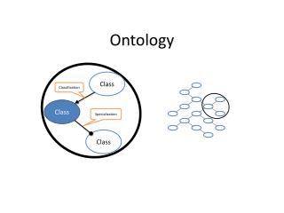
Ontology of Geography. XML 기술과응용. 건국대학교 정보통신대학원 이천연 김영천. 대 상. Geonames World Factbook Eurostat Lingvoj Riese Us Census Data Linked GeoData GovTrack. Overview - Ontology of Geography. Geography 대상 사이트에서는

E N D
Ontology of Geography • XML 기술과응용 • 건국대학교 정보통신대학원 • 이천연 • 김영천
대 상 Geonames World Factbook Eurostat Lingvoj Riese Us Census Data Linked GeoData GovTrack
Overview - Ontology of Geography Geography 대상 사이트에서는 기본적으로 GeoData에 대한 데이터가 수록되어 있으며, 그 외에 국회 기록 정보와 언어 정보등을 제공하고 있다. 대부분의 사이트는 GeoData에 인구, 사회적인 요소의 정보들을 제공하고 있으며, GeoData와 Map을 Mashup을 통한 서비스를 제공하고 있다. GeoData : 인구 통계(증가율, 사망율), 경제 통계(GDP rate), 국가의 지형(Building, Mountain, road 등), 도시정보
Overview - Ontology of Geography • Govtrack • 제공 서비스 : GeoData, 미국 의회 활동 추적, 국회 기록 자료, 법률 관련 자료 • 기타 서비스 : OPEN API 제공 • 특이 사항 : • GeoData와 국회 자료 및 법률 자료를 OPEN API를 통해 사용자 Mashup을 • 통한 사용을 가능하도록 되어 있다. • - 제공된 데이터에 대한 설문을 할 수 있도록 구성이 되어 있다. • 2. Linked GeoData • 제공 서비스 : GeoData(350만 노드와 20억개의Result RDF Data) • 기타 서비스 : Map 수정이 가능한 개인화 서비스 • 특이 사항 : • - OpenStreetMap에 의해 정보 수집 및 서비스 제공 • - Open Data를 통한 Mashup서비스 가능 • - Sparql를 통한 쿼리 가능
Overview - Ontology of Geography 3. US Census Data 제공 서비스 : GeoData(인구, 소득, 교육, 주택 소유 정보 등) 기타 서비스 : 인구 예측 프로그램 특이 사항 : - 조사원을 통한 데이터 수집 및 서비스 제공 - FactFinder라는 조사원에 의한 설문 조사 - 각종 통계 자료 제공 4. Riese 제공 서비스 : Eurostat의 GeoData를 이용하여 PHP스크립트로 정보 제공 기타 서비스 : XHTML + RDF 제공 특이 사항 : - 자체 정보를 수집하는 것이 아닌 Eurostat의 정보를 이용한 2차 서비스 제공 - 주요 클래스(riese:Dataset, riese:item, riese:dimension)를 제공
Overview - Ontology of Geography 5. GeoNames 제공 서비스 : GeoData(국가, 도시, 인구 등) 기타 서비스 : Map을 통한 개인 등록 자료 수집 및 서비스 제공 특이 사항 : - 각각의 등록된 GeoData에 대한 RDF 제공 - Google Map Mashup을 통한 서비스 제공하면 개인이 등록도 가능 - Ontology 2.0 Full RDF 제공 6. World Factbook 제공 서비스 : GeoData(266개 World Entities, 인구, 군사 등) 기타 서비스 : 서비스 항목별 Rank Order 서비스 제공 특이 사항 : - 미국 CIA에서 매년 갱신된 서비스를 유료로 제공하고 있음. - 다른 사이트에서 제공하지 않는 국가별 군사관련 정보도 제공하고 있음.
Overview - Ontology of Geography 7. Eurostat 제공 서비스 : Navigation Tree를 통한 테마별GeoData 서비스 제공 기타 서비스 : Chart을 이용한 DataView제공 특이 사항 : - 대부분의 사이트는 Map과 Mashup된 서비스를 제공하지만 본 사이트는 챠트를 통한 서비스 제공 - 유럽에 속한 국가들의 GeoData가 기본이며, 특이하게 미국과 일본의 정보가 포함되어 있음. 8. Lingvoj 제공 서비스 : 다중 언어 정보 기타 서비스 : RDF Schema를 통한 Define된 정보 제공 특이 사항 : - 언어를 검색하여 해당 언어에 대한 다중 언어 코드를 RDF Schema로 정의한 정보를 제공
Gov-track http://www.govtrack.us/
govtrack • GovTrack.us대하여 • GovTrack.us은 시빅 임펄스에서 도구 공공 연구 도움과 미국 의회의 활동을 추적, 홍보와 소설을 통해 정부의 투명성과 시민 교육의 기술 혁신을 추구한다. • 지도에 관한 정보뿐만 아니라 국회 기록에 대한 기록을 투표 미국 연방 법률를 확인할 수 있다. • 이사이트는 정부 웹사이트 지만 더 많은 연구정보를 무료로 이용할수 있다 • 개인 웹페이지에서 법안에 대한 위젯을 추가할 수 있다.법혁신과 연구도 GovTrack의 큰 몫을 한다. • 우리는 독특한 커뮤니티 Q&A 를 통해 정보를 얻을수 있다. • GovTrack데이터를 공유할수 있는 TOOL • 모바일App • Congress111 의해 회원에 대한 다양한 정보를 GovTrack의 데이터 제공한다.
govtrack 페이 스북 법률 과 지리 검색을 할수 있고 게시물을 읽고 설문을 할수 있다.
govtrack For Web Developers: APIs
govtrack <?xml version="1.0"?> <rdf:RDFxmlns:rdf="http://www.w3.org/1999/02/22-rdf-syntax-ns#" xmlns:vote="http://www.rdfabout.com/rdf/schema/vote/" xmlns:biblio="http://purl.org/ontology/bibo/" xmlns:foaf="http://xmlns.com/foaf/0.1/" xmlns:dcterms="http://purl.org/dc/terms/" xmlns:usgov="http://www.rdfabout.com/rdf/schema/usgovt/" xmlns:vcard="http://www.w3.org/2001/vcard-rdf/3.0#" xmlns:rdfs="http://www.w3.org/2000/01/rdf-schema#" xmlns:pol="http://www.rdfabout.com/rdf/schema/politico/" xmlns:dc="http://purl.org/dc/elements/1.1/" xmlns:bill="http://www.rdfabout.com/rdf/schema/usbill/" xmlns:time="http://pervasive.semanticweb.org/ont/2004/06/time#"> <rdf:Descriptionrdf:about="http://www.rdfabout.com/rdf/usgov/congress/99/bills/h4"> <bill:hadAction> <bill:LegislativeAction> <dc:description>Referred to House Committee on The Judiciary.</dc:description> <time:atrdf:datatype="http://www.w3.org/2001/XMLSchema#date">1985-01-03</time:at> </bill:LegislativeAction> </bill:hadAction> <bill:hadAction> <bill:LegislativeAction> <dc:description>Referred to Subcommittee on Crime.</dc:description> <time:atrdf:datatype="http://www.w3.org/2001/XMLSchema#date">1985-03-06</time:at> </bill:LegislativeAction> </bill:hadAction> <bill:hadAction> <bill:LegislativeAction> <dc:description>Subcommittee Hearings Held.</dc:description> <time:atrdf:datatype="http://www.w3.org/2001/XMLSchema#date">1985-05-09</time:at> </bill:LegislativeAction> </bill:hadAction> </rdf:Description> </rdf:RDF>
Linked GeoData http://linkedgeodata.org/
Linked geoData Linked geoData대하여 LinkedGeoData는 웹 데이터 / 시맨틱 웹의 데이터를 제공한다. LinkedGeoData는 정보를 OpenStreetMap에 의해 수집하고 사용하며, geoData사용할 수 RDF의 데이터에 형식을 제공한다. 또한 Open Data를 통하여 다른데이터와 연결 이 가능하다. Linked geoData는 현재 약 350 만 노드와 3000 만 방법과 결과 RDF의 데이터는 약 20 억개 구성되어 있습니다.
Linked geoData OpenStreetMap OpenStreetMap는 셰계 지도를 편집할 수 있다. 그 OpenStreetMap사용자가 수정할 수있는 지구 어디에서든 사용자제공 방식으로 지리 데이터를 사용한다.
Linked geoData SPARQL 사용하여 쿼리 RDF Data Access and Data Management http://docs.openlinksw.com/virtuoso/rdfsparqlgeospat.html
US Census Data http://www.census.gov/
Censuses 센서스 국은 많은 조사원을 두고 있다. 10 년동안,센서스 국은 미국과 세계 에있는 모든 인구 정보를 수집한다. 십년간의 국세 조사 십년간의 인구 조사 를 위해 모든 데이터를 매 10 년간 수집, 소득, 교육, 주택 소유정보데이터 수집원에게서 정보를받는다. 경제적 국세 조사 지역 수준으로 국가에서 경제 센서스 프로필 미국 경제 매 5 년, 그리고 세부 산업 및 비즈니스 분류를 한다. 인구 예측 프로그램 인구 예측 프로그램은 전년도 도시와 마을, 대도시에대한인구 합계를 낸다. 지리에 대하여 선택이가능하며 연령,성별,인종 민족성데이터를 수집하고 제공한다. 연간 경제 조사 센서스 국은 100 개 이상의 경제적인 설문 조사를 경제의 다양한 분야에 대해, 분기별, 연간 및 월별 기간에 걸쳐 실시하고 있다. FactFinder 라는 조사원에 의해 설문 조사를 시작 한다. 센서스 정보를 이용하는 한 구독자 영상이다.
http://www.youtube.com/watch?v=aEodKLTSi4s 다른 설문 조사 정보에 대해, 사회, 경제, 미국 인구의 주택 특성뿐만 아니라, 비즈니스, 인구 통계 산업 및 무역 정보, 여러 설문 조사에서 확인할 수 있다.
센서스에서는 데이터 툴을 제공한다. factf finder 제공한 데이터 FBI 가 제공하는 데이터 센서스 국 지오그래픽 제품 등을 제공한다.
Riese http://riese.joanneum.at/
Riese Reese 에 대하여 Riese은 2007 년 중반은 W3C SWEO에서 공동 프로젝트로 시작했다. riese시스템 구조는 아파치 2 서버, SWI 프롤로그 및 PHP 스크립트가 핵심에 있습니다. 데이터는 Eurostat에서 RDF의 / XML 변환됩니다. 렌더링 엔진에서 사용하는 템플릿이나 XHTML + RDF 만든다.
Riese http://riese.joanneum.at/about.html riese핵심 스키마는 아래와 같다. 현재 riese핵심 스키마는 RDF의 - S를 기반으로하며 세 가지 주요 클래스 : riese :Dataset, riese :item 및 riese : dimension 이다.
Riese http://riese.joanneum.at/about.html Riese’s source code
대 상 - Geonames Geonames www.geonames.org 서비스 종류 Countries Largest cities Highest mountains Capitals Postal codes Wikipedia Country statistics Recent modification
대 상 - Geonames • About Geonames • The GeoNames geographical database is available for download free of charge under a creative commons attribution license. It contains over eight million geographical names and consists of 7 million unique features where of 2.6 million populated places and 2.8 million alternate names. All features are categorized into one out of nine feature classes and further subcategorized into one out of 645 feature codes. (more statistics ...). The data is accessible free of charge through a number of webservices and a daily database export. GeoNames is already serving up to over 11 million web service requests per day. • Geographical name: 8,00,000건 • Unique features : 7,000,000건 • Feature codes : 645개 • Web Services : 110,000개 • Wikipedia와 연동하여 자유롭게 Geographical name 변경 가능 FREE SERVICE
대 상 - Geonames • About Geonames • The GeoNames geographical database is available for download free of charge under a creative commons attribution license. It contains over eight million geographical names and consists of 7 million unique features where of 2.6 million populated places and 2.8 million alternate names. All features are categorized into one out of nine feature classes and further subcategorized into one out of 645 feature codes. (more statistics ...). The data is accessible free of charge through a number of webservices and a daily database export. GeoNames is already serving up to over 11 million web service requests per day. • Geographical name: 8,00,000건 • Unique features : 7,000,000건 • Feature codes : 645개 • Web Services : 110,000개 • Wikipedia와 연동하여 자유롭게 Geographical name 변경 가능 FREE SERVICE
대 상 - Geonames 전쟁기념관(용산) 신규 정보를 입력 용산초등학교 미등록된 데이터 등록된 데이터
대 상 – World Factbook World Factbook www.cia.gov 266개의 World Entities
대 상 – World Factbook World Factbook 2010 by iPhone Apps 서비스 종류 Geography People Government Economy Communications Transportation Military Transnational Issues