Download
1 / 19
190 likes | 290 Views
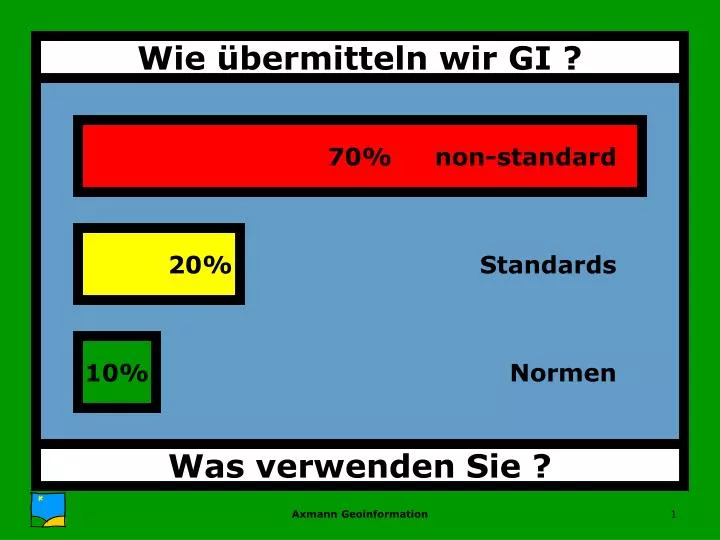
70%. non-standard. 20%. Standards. 10%. Normen. Wie übermitteln wir GI ?. Was verwenden Sie ?. Was ist eine Schnittstelle ?. DI Axel Axmann.

E N D
70% non-standard 20% Standards 10% Normen Wie übermitteln wir GI ? Was verwenden Sie ? Axmann Geoinformation
Was ist eine Schnittstelle ? DI Axel Axmann Axmann Geoinformation
interface : 1. surface forming a common boundary between two regions. 2. place, or piece of equipment, where interaction occurs between two systems, processes, etc. (The Concise Oxford Dictionary) • interface :The interface between two subjects, systems, etc is the area in which they affect each other or have links with each other(Collins, English Language Dictionary) Normen interface Axmann Geoinformation
Inhalt Sender Empfänger Sprache Bestandteile einer Schnittstelle Axmann Geoinformation
non-standard direkt non-standard mit Übersetzer Info wird standardisiert übermittelt Arten von Schnittstellen Axmann Geoinformation
Off-Line Typen von GI-Nutzung Axmann Geoinformation
On-Line damit das funktioniert ... Typen von GI-Nutzung Axmann Geoinformation
SW-Modul • Funktion Regelwerk Was ist eine Schnittstelle ? Axmann Geoinformation
Zustand A Modell A Zustand B Modell B Ziel Quelle Regelwerk Schnittstelle == Regelwerk Axmann Geoinformation
Analyse Quell-Datenmodell Analyse Ziel-Datenmodell Abbildungsregeln (Migrationsmodell) Test + QS Ausspielen aus Quellsys Konvertierung + QS Einspielen in Zielsystem Übertragung von GI off-line Axmann Geoinformation
Analyse Quell-Datenmodell Analyse Ziel-Datenmodell Zugriffsregeln Test + QS Inbetriebnahme + QS Nutzung von GI on-line Axmann Geoinformation
Semantik • KlassifizierungLayer, Ebenen, Klassen, feature type • Welche Parameter werden zur Klassifizierung verwendet • Welche Unterscheidungen werden mittels Attributen getroffen • Objektbegrifffeature, Bezugsgrößen, Strukturierung • was ist ein Objekt, wie weit geht es • Koordinaten • Projektion, GK/BMN, x/y + z, Lage- und Höhengenauigkeit • Topologie • Knoten/Kanten vs. Spaghetti NET / EZO / GRT • Attribute • Datentyp, Wertebereich, Maßeinheit, Vorkommnis (f/o), • Defaultwert Regelwerk für ... Axmann Geoinformation
Semantik • Visualisierungsvorschriften • Fillstyles, Linestyles, Symbols • Textausprägungen für Geometrie UND Attribute • Quelle der Daten • Art der Erfassung, Genauigkeit, Detaillierung, • Ansprechpartner • Generalisierung • Abrückung, Weglassung, Zusammenfassung, ... • Stand der Aktualität „Denken in Extrakten“ • Organisation der DateienÜbergriff, Schnitt, Ebenen für jede Klasse einen Metadatensatz Regelwerk zur ... Axmann Geoinformation
Syntax • Datenformat • Norm : Regelwerk, das durch eine staatliche oder internationale Institution geschaffen wird(ON, CEN, ISO, ANSI) • Standard (dt.): Regelwerk, das in der Praxis oft eingesetzt wird, und damit zum Allgemeingut geworden ist(DKM, EDBS) • Version (DXFv.12, DXFv.13, DXFv.14,...) last but not least ... Regelwerk zur ... Axmann Geoinformation
Inhalt Meta-Inhalt Sprache Regelwerk für ... Axmann Geoinformation
70% nicht-standard 20% tw. standardisiert • ÖNORM A2260, Kap. 4 Metadaten • ISO/TC 211, 15046-15 • OGC, Topic 11 10% standardisisert Übertragung von Meta-GI Axmann Geoinformation
70% Schnittstellen 20% Standards 10% Normen Wie übermitteln wir GI ? 10% nicht standardisiert 20% tw. standardisiert 70% standardisiert hoffentlich bald ! Axmann Geoinformation
Korrekturen Meta-Information Protokoll Insert/Update Parametrisierung Zeit SW-Funktion Musterplan Menschen Regelwerk Methoden Musterdaten Organisation Budget Performance Qualitätssicherung Kontrolle Planung Management Was ist eine Schnittstelle ? Axmann Geoinformation