Download
1 / 1
10 likes | 92 Views
A Small Community’s Dilemma: Case Study of Coastal Hazard Assessment and Mitigation, Palo Seco, Puerto Rico Bush, David M. 1 , Jackson, Chester W., Jr. 2 , Maloof, Andrew J. 1 , Petruccelli, Rochelle F. 1 , and Neal, William J.* 3

E N D
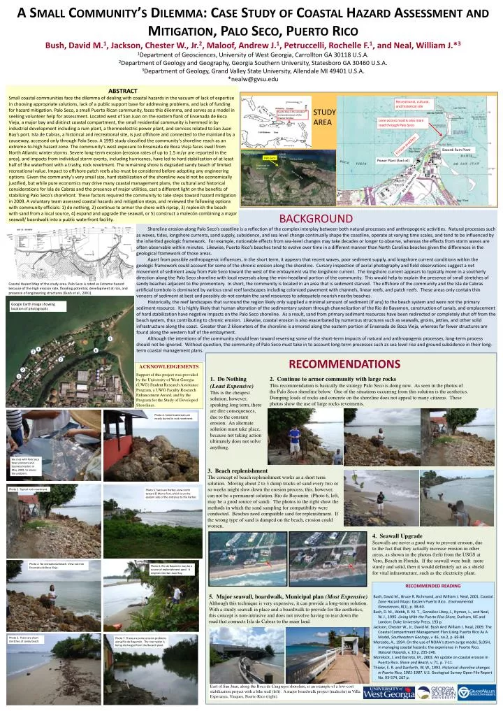
A Small Community’s Dilemma: Case Study of Coastal Hazard Assessment and Mitigation, Palo Seco, Puerto Rico Bush, David M.1, Jackson, Chester W., Jr.2, Maloof, Andrew J.1, Petruccelli, Rochelle F.1, and Neal, William J.*3 1Department of Geosciences, University of West Georgia, Carrollton GA 30118 U.S.A. 2Department of Geology and Geography, Georgia Southern University, Statesboro GA 30460 U.S.A. 3Department of Geology, Grand Valley State University, Allendale MI 49401 U.S.A. *nealw@gvsu.edu 5 4 Bacardi Rum Plant 6 3 Palo Seco Power Plant (fuel oil) 7 2 1 Río de Bayamón ABSTRACT Small coastal communities face the dilemma of dealing with coastal hazards in the vacuum of lack of expertise in choosing appropriate solutions, lack of a public support base for addressing problems, and lack of funding for hazard mitigation. Palo Seco, a small Puerto Rican community, faces this dilemma, and serves as a model in seeking volunteer help for assessment. Located west of San Juan on the eastern flank of Ensenada de Boca Vieja, a major bay and distinct coastal compartment, the small residential community is hemmed in by industrial development including a rum plant, a thermoelectric power plant, and services related to San Juan Bay’s port. Isla de Cabras, a historical and recreational site, is just offshore and connected to the mainland by a causeway, accessed only through Palo Seco. A 1995 study classified the community’s shoreline reach as an extreme-to-high hazard zone. The community’s west exposure to Ensenada de Boca Vieja faces swell from North Atlantic winter storms. Severe long-term erosion (erosion rates of up to 1.5 m/yr are reported in the area), and impacts from individual storm events, including hurricanes, have led to hard stabilization of at least half of the waterfront with a trashy, rock revetment. The remaining shore is degraded sandy beach of limited recreational value. Impact to offshore patch reefs also must be considered before adopting any engineering options. Given the community’s very small size, hard stabilization of the shoreline would not be economically justified, but while pure economics may drive many coastal management plans, the cultural and historical considerations for Isla de Cabras and the presence of major utilities, cast a different light on the benefits of stabilizing Palo Seco’s shorefront. These factors required the community to take steps toward hazard mitigation in 2009. A voluntary team assessed coastal hazards and mitigation steps, and reviewed the following options with community officials: 1) do nothing, 2) continue to armor the shore with riprap, 3) replenish the beach with sand from a local source, 4) expand and upgrade the seawall, or 5) construct a malecón combining a major seawall/ boardwalk into a public waterfront facility. STUDY AREA Puerto Rico is the smallest and easternmost of the Greater Antilles Isla de Cabras Punta Salinas Old San Juan Ensenada de Boca Vieja San Juan Bay Levittown BACKGROUND Shoreline erosion along Palo Seco’s coastline is a reflection of the complex interplay between both natural processes and anthropogenic activities. Natural processes such as waves, tides, longshore currents, sand supply, subsidence, and sea level change continually shape the coastline, operate at varying time scales, and tend to be influenced by the inherited geologic framework. For example, noticeable effects from sea-level changes may take decades or longer to observe, whereas the effects from storm waves are often observable within minutes. Likewise, Puerto Rico’s beaches tend to evolve over time in a different manner than North Carolina beaches given the differences in the geological framework of those areas. Apart from possible anthropogenic influences, in the short term, it appears that recent waves, poor sediment supply, and longshore current conditions within the geologic framework could account for some of the chronic erosion along the shoreline. Cursory inspection of aerial photography and field observations suggest a net movement of sediment away from Pale Seco toward the west of the embayment via the longshore current. The longshore current appears to typically move in a southerly direction along the Palo Seco shoreline with local reversals along the mini-headland portion of the community. This would help to explain the presence of small stretches of sandy beaches adjacent to the promontory. In short, the community is located in an area that is sediment starved. The offshore of the community and the Isla de Cabras artificial tombolo is dominated by various coral reef landscapes including colonized pavement with channels, linear reefs, and patch reefs. These areas only contain thin veneers of sediment at best and possibly do not contain the sand resources to adequately nourish nearby beaches. Historically, the reef landscapes that surround the region likely only supplied a minimal amount of sediment (if any) to the beach system and were not the primary sediment resource. It is highly likely that human alteration of the sedimentary system through channelization of the Rio de Bayamon, construction of canals, and emplacement of hard stabilization have negative impacts on the Palo Seco shoreline. As a result, sand from primary sediment resources have been redirected or completely shut off from the beach system, thus contributing to chronic erosion. Likewise, coastal erosion is also exacerbated by numerous structures such as seawalls, groins, jetties, and other solid infrastructure along the coast. Greater than 2 kilometers of the shoreline is armored along the eastern portion of Ensenada de Boca Vieja, whereas far fewer structures are found along the western half of the embayment. Although the intentions of the community should lean toward reversing some of the short-term impacts of natural and anthropogenic processes, long-term process should not be ignored. Without question, the community of Palo Seco must take in to account long-term processes such as sea level rise and ground subsidence in their long-term coastal management plans. Coastal Hazard Map of the study area. Palo Seco is rated as Extreme hazard because of the high erosion rate, flooding potential, development at risk, and presence of engineering structures (Bush et al., 2001). Recreational, cultural, and historical site Lone access road is also main road through Palo Seco Google Earth image showing location of photographs Erosion problem RECOMMENDATIONS Acknowledgements Support of this project was provided by the University of West Georgia (UWG) Student Research Assistance Program, a UWG Faculty Research Enhancement Award, and by the Program for the Study of Developed Shorelines. 1. Do Nothing (Least Expensive) This is the cheapest solution, however, speaking long term, there are dire consequences, due to the constant erosion. An alternate solution must take place, because not taking action ultimately does not solve anything. 2. Continue to armor community with large rocks This recommendation is basically the strategy Palo Seco is doing now. As seen in the photos of the Palo Seco shoreline below. One of the situations occurring from this solution is the aesthetics. Dumping loads of rocks and concrete on the shoreline does not appeal to many citizens. These photos show the use of large rocks revetments. Photo 5. San Juan Harbor, view north toward El Morro Fort, which is on the eastern side of the entrance to the harbor. Photo 1. Typical rock revetment. We met with Palo Seco town planners and business leaders in May, 2009, to assess the problem. 3. Beach replenishment The concept of beach replenishment works as a short term solution. Moving about 2 to 3 dump trucks of sand every two or so weeks might slow down the erosion process, this, however, can not be a permanent solution. Río de Bayamón (Photo 6, left, may be a good source of sand). The photos to the right show the methods in which the sand sampling for compatibility were conducted. Beaches need compatible sand for replenishment. If the wrong type of sand is dumped on the beach, erosion could worsen. Photo 6. Río de Bayamón may be a source of replenishment sand. It empties into San Juan Bay. Photo 2. No recreational beach. View out into Ensenada de Boca Vieja. 4. Seawall Upgrade Seawalls are never a good way to prevent erosion, due to the fact that they actually increase erosion in other areas, as shown in the photos (left) from the USGS at Vero, Beach in Florida. If the seawall were built more sturdy and solid, then it would definitely act as a shield for vital infrastructure, such as the electricity plant. Photo 4. Some businesses are nearly buried in rock revetment. Photo 7. There are some erosion problems along Río de Bayamón. The river water is being discharged from the Bacardi plant. Photo 3. There are short stretches of sandy beach. RECOMMENDED READING Bush, David M., Bruce R. Richmond, and William J. Neal, 2001. Coastal Zone Hazard Maps: Eastern Puerto Rico. Environmental Geosciences, 8(1), p. 38-60. Bush, D. M., Webb, R. M. T. , González Liboy, J., Hyman, L., and Neal, W. J., 1995. Living With the Puerto Rico Shore, Durham, NC and London: Duke University Press, 193 p. Jackson, Chester W., Jr., David M. Bush And William J. Neal, 2009. The Coastal Compartment Management Plan:Using Puerto Rico As A Model, Southeastern Geology, v. 46, no.2, p. 69-84. Mercado, A., 1994. On the use of NOAA's storm surge model, SLOSH, in managing coastal hazards: the experience in Puerto Rico. Natural Hazards, v. 10 p. 235-246. Morelock, J. and Barreto, M., 2003. An update on coastal erosion in Puerto Rico. Shore and Beach, v. 71, p. 7-11. Thieler, E. R. and Danforth, W. W., 1993. Historical shoreline changes in Puerto Rico, 1901-1987. U.S. Geological Survey Open-File Report No. 93-574, 267 p. 5. Major seawall, boardwalk, Municipal plan (Most Expensive) Although this technique is very expensive, it can provide a long-term solution. With a sturdy seawall in place and a boardwalk to provide for the aesthetics, this concept is non-intrusive and does not involve having to tear down the road that connects Isla de Cabras to the main land. East of San Juan, along the Boca de Cangrejos shoreline, is an example of a low-cost stabilization project with a bike trail (left). A major boardwalk project (malecón) in Villa Esperanza, Vieques, Puerto Rico (right).