Download
1 / 35
350 likes | 452 Views
SOA-based Wetlands Jurisdictional Determination Tools John Davidson and Jeff Ehman, Ph.D. FGDC SOA Workshop, 9 June 2009. Agenda. Part I: Introduction Purpose, Objectives, Approach Background Business Drivers Part II: Demo

E N D
SOA-based Wetlands Jurisdictional Determination Tools John Davidson and Jeff Ehman, Ph.D. FGDC SOA Workshop, 9 June 2009
Agenda • Part I: Introduction • Purpose, Objectives, Approach • Background • Business Drivers • Part II: Demo • Geoanalysis Decision Support Tool for Wetlands Jurisdictional Determination (JD) • Part III: Best Practices and Lessons-learned Page 2
Part I: Introduction A collaboration of EPA (Office of Water), USACE, FWS, and others including USDA, USGS, FGDC, and State of Maryland.
Purpose and Objectives Purpose Refine SOA best practices through implementation experience Provide SOA guidance for other Federal agencies Provide a SOA-based capability that streamlines a step in the wetlands permitting process Objectives Demonstrate SOA-based capability integrated with new tools and business processes being developed by partners EPA and USACE Document and share best-practices and lessons learned • Page 4
Problem • Past state: manually intensive business processes using localized datasets with stepwise interactions between stakeholders – a brittle and time-consuming process • Desired state: streamlined business process that enables multi-party collaboration and sharing of data and supports new analytical requirements
Approach • A SOA-based geoprocessing capability • integrate with EPA DARTER, Office of Water’s new Web-based software platform used to manage the wetland permitting process • augment ability of EPA Analysts to make and share Jurisdictional Determinations (JDs) online • Low-cost, license free, multi-use • Existing solutions for the Web-based GIS* can be costly • Leverage open-source and royalty-free software for building scalable, rich-client GIS that runs in a browser • Easily accessible via Web services and browser-based applications • Standards-based – uses OGC Web Services via HTTP GET and POST bindings (i.e., simple) • Web Map Service (WMS), Web Feature Service (WFS), and Web Processing Service (WPS)
GeoAnalysis Tool – Developing the GeoWeb • Runs in browser • Backed by shared Web Services • Integrates NWI, NHD, LiDAR and Orthoimagery • Annotate and share results
Background • By law, EPA and ACE must be able to answer this question: • Which wetlands are regulated under the Clean Water Act (CWA), Section 404? • ACE conducts jurisdictional determination and makes decisions on permits; enforces CWA Section 404 • EPA determines scope of geographic jurisdiction and applicability of exemptions; reviews and comments on permit applications; escalates cases; enforces CWA Section 404 • Both EPA and ACE use OMB Circ. A-16 themes: National Wetlands Inventory (NWI), National Hydrography Dataset (NHD), and other NSDI framework layers (e.g., Elevation and Orthoimagery) • FWS is the lead agency for NSDI wetlands theme and has responsibility to “readily share” NWI data (A-16) • Supreme Court “Raponos Decision” (2006) altered the definition of regulated wetland as “a water of the United States”. • EPA and ACE are working together to build new online capabilities (DARTER and ORM2) to address the changing regulatory/ statutory/ enforcement landscape and new business processes.
Vocabulary after Rapanos Decision • Clean Water Act (CWA) regulatory authority extended to only: • Relatively permanent, standing or continuously flowing bodies of water, connected to traditional navigable waters and to, • Wetlands with a continuous surface connection to such relatively permanent waters. • Did not necessarily excludeseasonal rivers which contain continuous flow during some months of the year but no flow during dry months. • Held that CWA jurisdiction extends to wetlands that “possess a ‘significant nexus’ to traditional navigable waters.” • Wetlands have this nexus if they “alone or in combination with similarly situated lands in the region, significantly affect the chemical, physical, and biological integrity of traditional navigable waters.” “...Justice Kennedy’s approach will have the effect of creating additional work for all concerned parties.” Judge Stevens
Waters that are “Scalia Waters” • Navigable Waters • Wetlands abutting Navigable Waters • Perennial Tributaries (relatively permanent waters) • Intermittent Tributaries that flow seasonally These Waters do not require a “Significant Nexus” analysis but do require documentation
Waters Requiring Additional Analysis for Jurisdiction • Some Intermittent Streams (flow less than seasonally) • Wetlands adjacent (near) but not abutting perennial streams • Wetlands adjacent to intermittent and ephemeral streams • Ephemeral Streams These Waters will Require “Significant Nexus” Analysis
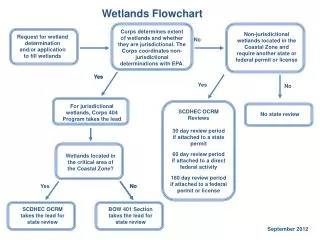
This is where EPA JD occurs. JD Business Process 60-90K permits/year ~300/day ~110 analysts 10% of USACE (6-9K permits/year) ~30/day require geoanalysis ~45 analysts
Resources used to support Jurisdictional Determination • Geospatial Data • Aerial Photography • Literature • Reference Conditions • Models • Local Knowledge • Expert Reports • GIS Findings from JD analysis can be packaged and attached to permit case folders. Peter Stokely, ASWM “Wetlands 2007” Conference Page 13
“Scalia Water” Analysis - Intersection Algorithm finds portion of NHD lines which intersect with selected NWI polygons. For each intersecting NHD line identified, the ID, length, and geometry of that line are returned. User selects NWI polygons in area of interest (AOI), e.g., by drawing box on screen.
“Significant Nexus” Analysis - Proximity Algorithm finds distance from point on each NWI polygon to nearest point on NHD line feature. For each NWI polygon the distance to the nearest point on an NHD feature and the ID of that feature is returned. User selects NWI polygons in AOI (as input_1) and specifies NHD lines (as input_2.
Partner data sharing Localized/Partner data sharing Geoprocessing Web Services NSDI Framework Data Sharing SOA Concept of Operation
MD Wetlands, Orthos, LiDAR, NSD & NWI HiRes NHD (USGS, NSDI Framework) NWI (FWS & Maryland, NSDI Framework) LiDAR (USDA/Maryland) Not shown: • 2007 NAIP (USGS, NSDI Framework) • Wetland Permits (USACE)
Part II: Demonstration • http://beta.usersmarts.com/epa-analysis/
User Steps • Zoom to AOI • Select NWI polys • Draw box to select wetlands and specify name of results set to invoke WPS (Details tab) • Get resulting report and edit metadata (Title and Description) • View tabular results (Features table) • View map results • Add contextual layers (e.g., LiDAR backdrop) and draw annotations (e.g., blue line) • Save Report to Folder or export to HTML and/or CSV and attach to the JD Case File. Page 19
Part III: Best Practices, Conclusion, and Observations “Remember, adding Web Services interfaces to an existing architecture does not SOA make. Take the SOA term and reverse it: instead of Service-oriented architecture, say Architecture Oriented toward Services.” - Jason Bloomberg/Zapthink, March 2005 … maybe but you have to start somewhere for refresh and integration of legacy and in-place capabilities.
Best Development Practices Understand the business processes Capture the use cases and data flows Develop tools to communicate with end-usersandsoftware developers Use cases and storyboards work great! Important: Use cases are the basis for testing Catalog your Functional Requirements Iterate on the Design Document (Draft & Final) System Diagram Sequence Diagrams to show service interactions for each use-case Implementation Understand the target runtime environment and integrations Choose your development tools and frameworks early Iterate on Integration Plan (Draft & Final) Iterate on Test Plan (Initial, Final) Start with use cases and requirements! Analyze results and go to Break-Fix cycle sooner. Don’t forget the Installation and Maintenance Plan • Page 22
From Business Process to Use Cases Use Case Business Process
Understand the Data and Services Page 25
Catalog Functional Requirements • Must connect to and query the NWI Web Feature Service (WFS) to identify wetland features • Must display wetland query results on a map • Must connect to and query the NHD Web Feature Service (WFS) to identify stream features • Must connect to and invoke a Web Processing Service (WPS) to perform intersection-based and proximity-based analysis of wetlands and streams • Must display analysis results in tabular form and on a map • Should provide the user the ability to select wetlands and streams from the map and display information (e.g., attributes) about them • Should allow the user to browse the wetland and stream features used in the analysis within a report detailing the results of the analysis • Should allow the user to specify annotations on the map which are persisted with the report Page 26
Easy to change deployment of services for improved performance and maintainability. Ripe for the Cloud! Unanticipated performance issues? Resolved! Iterate the Deployment Architecture & Integration Plan Rich Internet Application (AJAX) in the Browser. No pushing software patches to users.
Conclusion • Identify best practices that resulted from this work that are relevant in the federal/intergovernmental environment • Use of OGC standards for Web mapping (WMS), feature (WFS), and processing (WPS) services • See “Best Development Practices” slides above. • What is the level of maturity and viability of the referenced SOA/Cloud solutions or infrastructure within a governmental computing environment? • Mature: Some of the SOA solutions are relatively mature (e.g., WMS and WFS capabilities of USGS, NASA, NRCS, NOAA, and others). • Immature: Cloud solutions. But with SOA, where services are deployed should be transparent (not matter). • Immature: Standardized and simple identity management and service authentication for SOA (there’s hope: see CubeWerx presentation!)
Conclusion (2) • What are perceived impediments to adoption of your highlighted SOA/cloud practices in the government environment? • Variability in the implementation of OGC and other Web Services hinders rapid connection and reuse. • SOA benefits relative to desktop GIS. • Scientist: “I can already do that on my desktop GIS, what does SOA do for me? • Unplanned integration. • Integration Plan to coordinate with project plans/schedules and software development lifecycle is essential. • Plan for regular technology-refresh and new technology insertions… SOA can help with this. • Unplanned security. • Address security up-front (esp. when dealing with sensitive data). Win confidence of management first. Design and build for it from start. • Organizational readiness. • Make sure everybody’s on board. Page 31
Observations on SOA Benefits • Each incremental capability or new service becomes part of an agency service portfolio • Quick(er) time to benefit (ROI) • Availability to all who need it – highly scalable • Leave data with its steward • As sophistication of new services increase, incremental costs do not • Ease of use. Complexity stays under the hood – minimal training, easier maintenance.
Observations on SOA Lessons • Prototype to incrementally build and test new capabilities • Use to communicate and coordinate capabilities and requirements • Rapid development (e.g., 1-2 week increments) • Refining the user experience (uX) takes time! • Rich Internet applications can be developed and delivered through the thinnest of clients • Far more functionality than just Web-mapping – geospatial analysis over the Web without expensive server or desktop software. • The line between GIS and the GeoWeb is blurring with lots of choices • Standards-based framework is essential • EPA (and partner) voices are advocating standards, and the volume is approaching “11” ! • Real money required to host services • People, gear, licenses, SLAs
Issues, Opportunities, Next Steps? • Apply WPS for other specific EPA needs or as a generic geoprocessing service. • Lots of good work getting done out there (e.g., CAP Grants). Need to make these tools more widely known, available, and reusable! • Find opportunities for G2G collaboration… sharing resources (not just data). • Permanent WFS for NWI data needed • Breaking News: a prototype WFS for NWI is now in The Cloud (IU Eucalyptus) • Ensure new LiDAR acquisitions will be Web accessible via WMS and WCS. • LiDAR for the Nation! Page 34
Thank You! • EPA: Tod Dabolt, Palmer Hough, Pete Stokely, Rose Kwok, Brian Topping, L.A. Darnell, Tim Richards, and Jerry Johnston • USFWS: Bill Wilen, Ralph Tiner, Jason Miller, and Tom Dahl • USACE: Jon Soderberg • USGS: Bruce Droster • USDA: Megan Lang, and Greg McCarty • Indus Corporation: Brad Cooper, Scott Kocher, and Ky Ostergaard • FGDC: Doug Nebert, and Gita Urban-Mathieux Page 35
John Davidson/ johnd@imagemattersllc.com Jeff Ehman/jeffe@imagemattersllc.com www.imagemattersllc.com A technology development and professional services company