Download
1 / 18
180 likes | 319 Views
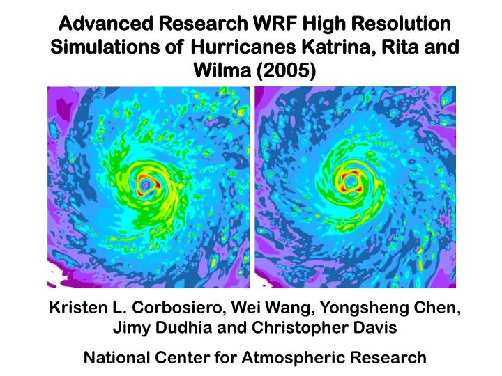
Advanced Research WRF High Resolution Simulations of Hurricanes Katrina, Rita and Wilma (2005) Kristen L. Corbosiero, Wei Wang, Yongsheng Chen, Jimy Dudhia and Christopher Davis National Center for Atmospheric Research. The Advanced Hurricane WRF

E N D
Advanced Research WRF High Resolution Simulations of Hurricanes Katrina, Rita and Wilma (2005) Kristen L. Corbosiero, Wei Wang, Yongsheng Chen, Jimy Dudhia and Christopher Davis National Center for Atmospheric Research
The Advanced Hurricane WRF • Run in real-time at NCAR since 2004 when a tropical cyclone (TC) threatened to make landfall within 3-5 days • Two or three domains (12, 4, 1.33 km) with two-way moveable nests that follow the hurricane center • Initialized from GFDL at 00 UTC and/or 12 UTC • Kain-Fritsch cumulus (12 km only), WSM3 microphysics, YSU PBL scheme, drag (Donelan) and surface enthalpy coefficients (Carlson-Boland) for TCs • Available on the web at http://www.wrf-model.org/plots/realtime_main.php
2005 performance Seven tropical cyclone forecast systems AHW4WRF 4 kmOFCLNational Hurricane Center officialGFDLGeophysical Fluid Dynamics LaboratoryFSSEFlorida State Super Ensemble Davis et al. (2007)
Hurricane Rita 03 UTC 24 September 39 hr forecast cm Column maximum reflectivity 4 km Precipitable water
Hurricane Wilma 4 km Precipitable water cm 22 UTC 20 October22 hr forecast 05 UTC 24 October77 hr forecast
HurricaneKatrina Precipitable water 12 km21 UTC 8/28 1.33 km00 UTC 8/29 4 km03 UTC 8/29 cm
Corbosiero et al. (2006) Kossin & Schubert (2004) Lewis & Hawkins (1982) Reasor et al. (2000)
Katrina Radar Reflectivity20 UTC 28 August Top: WRF 4 km(left), 1.33 km(right)Right: ELDORA radar RAINEX JOSS Field Catalog
1752 1930 2036 2232 HRD/AOML/NOAA
Katrina Wind speed Left:Dual Doppler 1725-1946 UTC28 AugustRight:WRF 1.33 km 18 UTCTop: 700 hPaBottom: 900 hPa m/s HRD/AOML/NOAA
Rita Wind speed Left:Dual Doppler 2015-2208 UTC23 SeptemberRight:WRF 4 km 01 UTC24 September Top: 700 hPaBottom: 900 hPa m/s HRD/AOML/NOAA
Both the real and WRF vorticity profiles exhibit sharp gradients of vorticity and changes in the sign of ∂ζ/ ∂r. Such profiles satisfy the necessary condition for barotropic instability.
Katrina 1.33 km WRF900 hPa wind speed m/s 900 hPa relative vorticity x 10-4 s-1
Linear stability analysis The 1.33 km WRF simulation is most unstable to wavenumber 2, with significant wavenumber 1-4 instability. The 4 km WRF simulation is most unstable to wavenumbers 1 and 2, with very little instability at higher wavenumbers. Code provided by M. Montgomery and M. Bell
Questions and Unresolved Issues • Are model numerics and parameterizations playing a role in the abundance of triangular eyewalls? • Do tropical cyclones pose a unique problem to WRF with their circular geometry and strong diabatic heating- vorticity generation feedback? • Will 1.33 km WRF TCs always be too weak due to an abundance of eyewall asymmetries? • What is the resolution dependence of these eyewall structures?
Vertical motion (warm up, cool down)185 m resolution Idealized WRF hurricane simulation The eyewall is predominantly circular or elliptical, with transient higher wavenumber structures.
Future Work • Add another nest to the 1.33 km Katrina run to test resolution dependence • Decompose the WRF output into its various wavenumber components and compare with observations • Analyze the results of the 2007 hurricane season WRF 1.33 km runs We’re not alone! WRF 2km WilmaGFS initialization Brian EthertonUNC Charlotte