Download
1 / 1
10 likes | 79 Views
Vegetation layer created without the known emergent vegetation area and using Technique 1: Thiessen polygon. Vegetation layer created with the known emergent vegetation area and using Technique 1: Thiessen polygon.

E N D
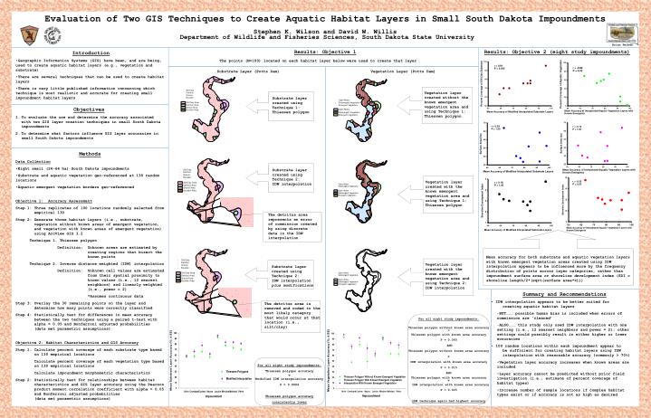
Vegetation layer created without the known emergent vegetation area and using Technique 1: Thiessen polygon Vegetation layer created with the known emergent vegetation area and using Technique 1: Thiessen polygon Vegetation layer created with the known emergent vegetation area and using Technique 2: IDW interpolation Substrate layer created using Technique 2: IDW interpolation plus modifications Substrate layer created using Technique 1: Thiessen polygon Substrate layer created using Technique 2: IDW interpolation Evaluation of Two GIS Techniques to Create Aquatic Habitat Layers in Small South Dakota Impoundments Stephen K. Wilson and David W. Willis Department of Wildlife and Fisheries Sciences, South Dakota State University Brian Heikes Results: Objective 1 Results: Objective 2 (eight study impoundments) • Introduction • Geographic Information Systems (GIS) have been, and are being, used to create aquatic habitat layers (e.g., vegetation and substrate) • There are several techniques that can be used to create habitat layers • There is very little published information concerning which technique is most realistic and accurate for creating small impoundment habitatlayers The points (N=100) located on each habitat layer below were used to create that layer Substrate Layer (Potts Dam) Vegetation Layer (Potts Dam) • Objectives • To evaluate the use and determine the accuracy associated with two GIS layer creation techniques in small South Dakota impoundments • To determine what factors influence GIS layer accuracies in small South Dakota impoundments • Methods • Data Collection • Eight small (24-64 ha) South Dakota impoundments • Substrate and aquatic vegetation geo-referenced at 130 random locations • Aquatic emergent vegetation borders geo-referenced • Objective 1: Accuracy Assessment • Step 1: Three replicates of 100 locations randomly selected from empirical 130 • Step 2: Generate three habitat layers (i.e., substrate, vegetation without known areas of emergent vegetation, and vegetation with known areas of emergent vegetation) using ArcView GIS 3.2 • Technique 1. Thiessen polygon • Definition: Unknown areas are estimated by creating regions that bisect the known points • Technique 2. Inverse distance weighted (IDW) interpolation • Definition: Unknown cell values are estimated from their spatial proximity to known values (i.e., 12 nearest neighbors) and linearly weighted (i.e., power = 2) • *Assumes continuous data • Step 3: Overlay the 30 remaining points on the layer and determine how many points were correctly classified • Step 4: Statistically test for differences in mean accuracy between the two techniques using a paired t-test with alpha = 0.05 and Bonferroni adjusted probabilities (data met parametric assumptions) • Objective 2: Habitat Characteristics and GIS Accuracy • Step 1: Calculate percent coverage of each substrate type based on 130 empirical locations • Calculate percent coverage of each vegetation type based on 130 empirical locations • Calculate impoundment morphometric characteristics • Step 2: Statistically test for relationships between habitat characteristics and GIS layer accuracy using the Pearson product moment correlation coefficient with alpha = 0.05 and Bonferroni adjusted probabilities (data met parametric assumptions) The detritus area represents an error of commission created by using discrete data in the IDW interpolation Mean accuracy for both substrate and aquatic vegetation layers with known emergent vegetation areas created using IDW interpolation appears to be influenced more by the frequency distribution of points across layer categories, rather than impoundment surface area or shoreline development index (SDI = shoreline length/2*(sqrt(surface area*))) Summary and Recommendations • IDW interpolation appears to be better suited for creating aquatic habitat layers • BUT……… possible human bias is included when errors of commission are ‘cleaned’ • ALSO……… this study only used IDW interpolation with one setting (i.e., 12 nearest neighbors and power = 2); other settings could possibly result in either higher or lower accuracies • 100 random locations within each impoundment appear to be sufficient for creating habitat layers using IDW interpolation with reasonable accuracy (commonly > 70%) • Vegetation layer accuracy increases when known areas are included • Layer accuracy cannot be predicted without prior field investigation (i.e., estimate of percent coverage of habitat types) • Increase number of sample locations if complex habitat types exist or if accuracy is not as high as desired The detritus area is removed and coded to the most likely category that would occur at that location (i.e., silt/clay) For all eight study impoundments: Thiessen polygon without known area accuracy = Thiessen polygon with known area accuracy P = 0.065 AND Thiessen polygon without known area accuracy IDW interpolation with known area accuracy P = 0.015 AND Thiessen polygon with known area accuracy IDW interpolation with known area accuracy P = 0.005 IDW technique again had highest accuracy For all eight study impoundments: Thiessen polygon accuracy Modified IDW interpolation accuracy P = 0.0006 Thiessen polygon accuracy consistently lower