Download
1 / 6
60 likes | 170 Views
Three Essential Components of Today’s Operational Numerical Prediction Enterprise. Observations ~2 billion/day 99.9% remotely sensed, mostly from satellites Models Earth System model; coupled Global resolution (27km) North American resolution (4km) Computer

E N D
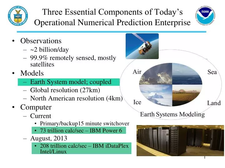
Three Essential Components of Today’s Operational Numerical Prediction Enterprise • Observations • ~2 billion/day • 99.9% remotely sensed, mostly from satellites • Models • Earth System model; coupled • Global resolution (27km) • North American resolution (4km) • Computer • Current • Primary/backup15 minute switchover • 73 trillion calc/sec – IBM Power 6 • August, 2013 • 208 trillion calc/sec – IBM iDataPlex Intel/Linux
Satellite Data Used Operationally • AVHRR SST • AVHRR vegetation fraction • AVHRR surface type • Multi-satellite snow cover • Multi-satellite sea ice • SBUV/2 ozone profile & total ozone • MODIS* polar winds • GPS Radio Occultation • COSMIC, METOP/GRAS,CNOFS GRACE,* SAC-C*, TerraSAR-X* • OMI* • MSG Seviri • HIRS sounder radiances • AMSU-A sounder radiances • AMSU-B sounder radiances • ATMS sounder radiances • AIRS* sounder radiances • IASI sounder radiances • GOES sounder radiances • GOES, Meteosat, GMS winds • GOES precipitation rate • SSM/I precipitation rates • TRMM* precipitation rates • SSM/I ocean surface wind speeds • ERS-2* ocean surface wind vectors • 1Quikscat* ocean surface wind vectors ASCAT • JASON ocean surface altimetry * Indicates Research Satellite or Sensor 1No longer available As of March, 2013
Non-Satellite Data Used Operationally • In-Situ • Radiosondes • Aircraft • Surface Stations (manned and automated) • Buoys • Ships • PIBALs • Dropsondes • Remotely Sensed • Radars • Profilers
Operational ECMWF system September to December 2008. Averaged over all model layers and entire global atmosphere. % contribution of different observations to reduction in forecast error. Note: 1) Sounders on Polar Satellites reduce forecast error most 2) Results are relevant for other NWP Centers, including NWS/NCEP Forecast error contribution (%) Courtesy: Carla Cardinali and Sean Healy, ECMWF
Impact of Various Observing Systems in GSI/GEOS-5 01 Sep – 31 Dec 2010 00z • Total Impact • AMSU-A radiances have • the largest impact globally, • but conventional data • (raob, aircraft) still very • important. GPSRO now a • significant contributor. • Impact Per Observation • Raobs get large weight in • the analysis and have large • IPO. Ship obs are few, but • are located where there • are few other in-situ data. Total Impact beneficial Impact Per Observation
Ongoing Opportunities/Challenges • Getting ready for JPSS!! • Plan for potential data gaps • Be ready at Day 1 • Getting ready for GOES R – full disc coverage of 16 image channels in 15 minutes • Expanding new hybrid DA • Higher resolution ensemble • 4DVAR capabilities w/o adjoint • OSSEs – advancement of new observing systems (e.g., wind lidar)