Download
1 / 10
100 likes | 114 Views
The Guatemalan Civil Aviation Authority Search and Rescue Mission is responsible for coordinating search and rescue operations in Guatemala. With a challenging geography and weather conditions, the mission relies on a team of volunteers and collaborators to respond to emergencies. This mission was created in 2008 following international regulations, and although it lacks resources and equipment, it plays a crucial role in aviation safety in Guatemala. This mission is not responsible for incidents involving ultralight aircraft, agricultural planes, and narcotrafficking airplanes.

E N D
GUATEMALAN CIVIL AERONAUTICS AUTHORITY SEARCH AND RESCUE MISSION M. A. RICARDO PRADO SAR MISSION COORDINATOR COMMERCIAL PILOT AIRPLANE AND HELICOPTER
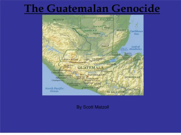
Guatemala islocated in Central America, with and area of 108,430 sq km. Its boundARIES ARE: Mexico to the north and west, the Pacific Ocean to the southwest, Belize and the Caribbean Sea to the east, Honduras and El Salvador to the southeast. More than 66% of the country is mountainous while 62% is covered by forests.
Guatemala HAS SEVERAL MOUNTAIN RANGES SOME OF WHICH GO AS HIGH AS 12,000 FEET ASL. the south coast area and northern land ARE FLAT. DIFFERENT mountain chains CROSS Guatemala from west to east, dividing the country in DIFFERENT CLIMATIC REGIONS. 23 VOLCANOES SIT PARALLEL TO THE SOUTH COAST. THE HIGHEST VOLCANO IS 14,000 FEET ASL.
THE GUATEMALAN CLIMATE is tropical and sub-tropical, but varies in relationSHIP to the altitude. Guatemala has two basic seasons: rainy, from May to October and dry, from November to April
GUATEMALA’S WEATHER AND GEOGRAPHY MAKE THE AIR OPERATIONS DIFFICULT AND VERY EASY FOR ACCIDENTS.
D Guatemala is one of the countries with major civil aviation throughout the world in proportion to its population. nowaday THERE ARE 571 aircraftS BETWEEN AIRplanes and helicopters.
GUATEMALA’S SAR MISSION WAS CREATED IN 2008, FOLLOWING THE ANNEX 12 REGULATION OF SEARCH AND RESCUE OPERATIONS IN ACCORDANCE TO THE INTERNATIONAL CIVIL AVIATION ORGANIZATION (ICAO). ACTUALLY GUATEMALA’S SAR MISSION DOESN´T HAVE THE EQUIPMENT AND RESOURCES TO MANAGE EMERGENCIES BY ITSELF, THEREFORE SEVERAL TEAMS OF VOLUNTEERS AND COLLABORATORS HAVE BEEN ORGANIZED WHICH INCLUDE PRIVATE OWNERS AND THE AIR FORCE.
In the YEAR 2008 23 accidents have OCCURRED 4 of WHICH WERE FATAL.
THERE ARE SEVERAL WAYS TO LEARN ABOUT INCIDENTS OR ACCIDENTS: 1) RADAR CONTACT; 2) CALLS FROM LOCAL PEOPLE; 3) RADIO CALLS FROM THE PILOTS; 4) MOBILE PHONES. AS SOON AS THE SAR MISSION HAS NOTICE OF AN ACCIDENT OR INCIDENT VERIFIES THE CERTAINTY OF THE NEWS AND THROUGH THE CEL PHONES SENDS MESSAGES TO THE TEAM OF COLLABORATORS APROXIMATELY 80 AND DECIDES HOW TO TREAT THE EMERGENCY. THROUGH THE CEL MESSAGES THE COLLABORATORS LEARN INSTANTLY WHAT IS GOING ON AND THEY MIGHT BE CLOSE TO THE ACCIDENT SITE GIVING AN INMEDIATE RESPONSE TO THE PROBLEM.
ULTRA LIGHT AIRCRAFTS, AGRICULTURAL PLANES, AND NARCOTRAFFIC AIRPLANES ARE NOT CONSIDERED RESPONSABILITY OF THE SAR MISSION FOR DIFFERENT REASONS.