Download
1 / 17
170 likes | 176 Views
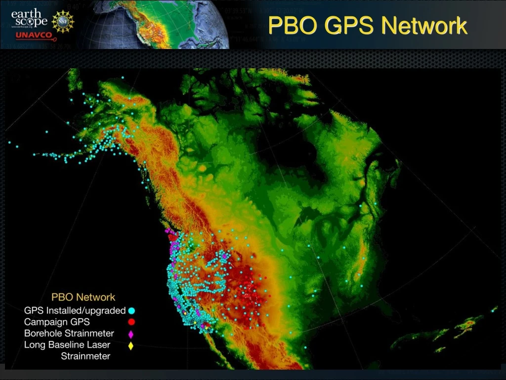
PBO GPS Network. PBO GPS Network. GPS Station Layout. MET Station. Cascadia Real Time. Why are real-time geodetic data products important?

E N D
GPS Station Layout MET Station
Cascadia Real Time • Why are real-time geodetic data products important? • For science-based hazard monitoring, real-time geodetic data are critical for determining static and dynamic displacements, slow slip and early post-seismic transients, and critical measurements between the seismic frequency band and static displacements. • Decisions and response can only be made as fast as the data are provide. • UNAVCO will provide realtime data delivery • Essential data products such as position estimates, tropospheric water content, ionospheric electron column density are not included in this proposal.
UNAVCO Real-time Geodetic data • What real-time GPS data are available from PBO? • What are the critical constraints on delivering real-time GPS data? • Who are the primary customers of these data sets? • What are the future plans with respect to real-time data for the PBO?
UNAVCO PBO RT Data • What are the availability of real-time geodetic products? • Currently UNAVCO in a beta-test phase streaming GPS data from ~84 PBO stations with an average receiver to PBO server latency of 1.11 s and an average of 93.2% data completeness. Data completeness is low because we are testing the “good, the bad, and the ugly” data communications scenarios. • For UNAVCO RT beta-test we are using a broad range data communications types including direct internet, VSAT, CDMA modem, and IP radio. • Note these are raw data only. Providing epoch-epoch solutions is a critical component of a science and hazards system.
Real-time Geodetic Data Definitions • What are real-time geodetic data and how do you assess the quality? • The definition of real-time data depends on the on the science target, sampling, rate, and latency of data from instrument to user. • For earthquake and volcano science and hazards applications we use a a 1 Hz sampling interval and latency requirement of < 5 seconds for data between station to processing center. • Also need to define a “completeness” metric. For earthquake and volcano hazards applications we use a 95% data completeness requirement. • Other considerations include station up-time and the ability to respond to maintenance issues.
Latency and Completeness Average latency 1.11 s Average completeness 93.2%
Cascadia Real-time • NSF proposed real-time upgrade of 232 stations in Cascadia. • Funded as part of the American Recovery and Reinvestment Act(ARRA) • Three year implementation plan • Initial upgrades focused on ETS critical stations • Priority based on science target, time line, location of personnel Before
Cascadia Real-time • Station upgrades include power augmentation and upgraded data communications • 3-G CDMA modems • removing VSATS • high speed radio networks • Purchase data distribution and QC software including latency, completeness, position estimation After
Year 1 Year 1 • Start work Fall 2009 • Upgrade Mount St. Helens stations • Upgrade 86 stations in fore-arc • Work driven by science targets and location of personnel
Year 1 Year 2 Year 2 • Upgrade 37 fore-arc stations in Oregon • Upgrade high altitude sites including Mt. Shasta/Lassen
Year 1 Year 3 Year 2 Year 3 • Upgrade remainder of back-arc stations