Download
1 / 35
360 likes | 384 Views
INTELLIGENT TRANSPORT SYSTEMS (ITS) IN DEVELOPING COUNTRIES. Presenter: Dr. Amos Japhet Nsanganzelu (PhD, MBA, B Com, CPA-ACPA 2471, ADTM, ACSCM, FCILT-Fellow of the Chartered Institute of Logistics and Transport) Institution: Dar es Salaam Institute of Technology (DIT) Company Limited.

E N D
INTELLIGENT TRANSPORT SYSTEMS (ITS) IN DEVELOPING COUNTRIES Presenter: Dr. Amos JaphetNsanganzelu (PhD, MBA, B Com, CPA-ACPA 2471, ADTM, ACSCM, FCILT-Fellow of the Chartered Institute of Logistics and Transport) Institution: Dar es Salaam Institute of Technology (DIT) Company Limited • Resilient Tanzania summit • 18-19FEBRUARY2019 • DarEs Salaam “Catalysingthe Benefits of Resilience and a National Resilience Program”
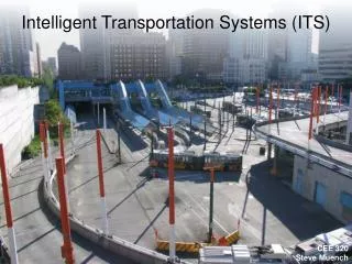
INTELLIGENT TRANSPORT SYSTEMS (ITS) IN DEVELOPING COUNTRIES 1.0 INTRODUCTION AND BACKGROUND • Transportation is a complex, large-scale, integrated, open system (CLIOS) • Transportation-an integrated system that interacts directly with the social, political and economic aspects of contemporary societies • The mobility and conveyance of people, freight and information is fundamental to economic and social activities such as commuting, manufacturing, distributing consumption goods or supplying energy • Transport Systems are the support and driver of this mobility and are composed of infrastructures, modes and terminals • This system enables the socio-economic life of individuals, institutions and corporations, as well as Governments.
2.0 Definition-ITS • An Intelligent Transportation System (ITS) is an advanced application which, without embodying intelligence as such, aims to provide innovative services relating to different modes of transport and traffic management and enable various users to be better informed and make safer, more coordinated and 'smarter'use of transport networks • Are Systems in which information and communication technologies are applied in the field all modes of transport, including infrastructure, vehicles and users, and in traffic management and mobility management, as well as for interfaces with other modes of transport • ITS may improve the efficiency of transport in a number of situations, i.e. General Transport, Traffic Management, Data/Information Management (TIMS), Mobility, R&M, Transport Budgeting, Transport Costing, Routes and Scheduling etc.
3.0 Reasons for ITS (Purpose) • Control Purposes • Safety Concerns • Monitoring and Evaluation (M&E) Purposes • Data Collection to Improve Mobility • Assisting in Improving the Meeting of Future Transport Requirements • Assisting in Planning for the Supply of Transport Facilities and Services • For Rewards and Punishments • For Reacting to Emergence or Unforeseen Situations • Prevention of Accidents and Collisions • Etc.
4.0 Tools for ITS • Tools include, but not limited to, the following: • Cameras, • Satellites, • Radars, • Intel Processors, • Computers (IT Systems), • Sensors, • Transmitters, • Robots, • GPS Systems
5.0 Functions of ITS • Intelligent Transport Systems (ITS) apply information, data processing, communication and sensor technologies to Carrying Units (CUs) (including cars, trucks, trains, aircrafts and ships), Transport Infrastructure and Transport Users: • to increase the: • Effectiveness, • Environmental Performance, • Safety, • Resilience and • Efficiency of the Transport System
6.0: Examples of High Level Governance Docs on ITS Examples of four key recent high-level Government documents concerning ITS (The Case of New Zealand): • The Intelligent Transport Systems Technology Action Plan-outlines the strategic context, the Government’s commitment, its thinking on its role and approach, and a programme of actions to encourage and enable the deployment of ITS in New Zealand. The Plan also gives examples of ITS systems and technologies. • For Land Transport and ITS in New Zealand, the Position Statement on Intelligent Transport Systems - Responding to the Opportunitieswhich was released in 2014 by the NZ Transport Agency. It outlines the Agency’s views on Intelligent Transport Systems, the opportunities they offer and how the Agency sees its role in making Intelligent Transport Systems an integral part of New Zealand’s Transport System. • For the Aviation and ITS in New Zealand, the New Southern Sky and the June 2014 National Airspace and Air Navigation Plan outline what is planned for Air Traffic Management Infrastructure in New Zealand. • The March 2018 Report Unlocking Commercial Opportunities from Intelligent Transport Systems which was commissioned by BusinessNZ and the Ministry of Transport on behalf of the Intelligent Transport System Advisory Group. This group was made up of a number of organisations from businesses and the Government. • New Zealand already has many examples of ITS in operation. For example, real-time systems to tell public transport users when their bus or train can be expected to arrive; variable message signs and ramp signalling on motorways; parking and blind spot warning systems in cars; and systems to help aircraft follow safe routes to and from airports. As computer technology becomes both cheaper and more powerful, more ITS technologies will be deployed in New Zealand over time. It is important the Governments are prepared for these technologies, so that they will be able to enact Laws and Regulations to ensure they do not miss out on the benefits that ITS can provide.
7.0: ITS Technologies • Intelligent Transport Systems (ITS) vary in the technologies applied • from basic management systems such as car navigation; traffic signalcontrol systems; container management systems; variable message signs; automatic number plate recognition or speed cameras; • to monitor applications, such as security CCTV systems; and • to more advanced applications that integrate live data and feedback from a number of other sources, such as parking guidance and informationsystems; weather information; bridge de-icing systems; and the like. • Additionally, predictive techniques are being developed to allow advanced modelling and comparison with historical baseline data. • Some of these technologies are described in the following sections.
7.0: Examples of ITS Technologies • Wireless Communications Traffic Monitoring Gantry with wireless communication dish antenna.
Examples of ITS Technologies Continued… • Computational (Computerised) Technologies • Recent advances in vehicle electronics have led to a move towards fewer, more capable computer processors on a vehicle. • A typical vehicle in the early 2000s would have between 20 and 100 individual networked microcontroller/Programmable logic controller modules with non-real-time operating systems. • The current trend is toward fewer, more costly microprocessor modules with hardware memory management and real-time operating systems. • The new embedded systemplatforms allow for more sophisticated software applications to be implemented, including model-based process control, artificial intelligence and ubiquitous computing. • Perhaps the most important of these for Intelligent Transportation Systems is the artificial intelligence.
Examples of ITS Technologies Continued… • Floating Car Data/Floating (Suspended) Cellular Data RFIDE-ZPass reader attached to the pole and its antenna (right) used in traffic monitoring in New York City by using vehicle re-identification method.
Examples of ITS Technologies Continued… • For the "Floating car" or "probe" the data collected is used on other transport routes. • Broadly speaking, four methods have been used to obtain the raw data: • Triangulation Method. In developed countries a high proportion of cars contain one or more mobile phones. The phones periodically transmit their presence information to the mobile phone network, even when no voice connection is established. In the mid-2000s, attempts were made to use mobile phones as anonymous traffic probes. As a car moves, so does the signal of any mobile phones that are inside the vehicle. By measuring and analysing network data using triangulation, pattern matching or cell-sector statistics (in an anonymous format), the data was converted into traffic flow information. With more congestion, there are more cars, more phones, and, thus, more probes. • In metropolitan areas, the distance between antennas is shorter and, in theory, accuracy increases. An advantage of this method is that no infrastructure needs to be built along the road; only the mobile phone network is leveraged. But in practice the triangulation method can be complicated, especially in areas where the same mobile phone towers serve two or more parallel routes (such as a motorway (freeway) with a frontage road, a motorway (freeway) and a commuter rail line, two or more parallel streets, or a street that is also a bus line). By the early 2010s, the popularity of the triangulation method was declining • Vehicle re-identification. Vehicle re-identification methods require sets of detectors mounted along the road. In this technique, a unique serial number for a device in the vehicle is detected at one location and then detected again (re-identified) further down the road. Travel times and speed are calculated by comparing the time at which a specific device is detected by pairs of sensors. This can be done using the MAC addresses from Bluetooth or other devices, or using the Radio Frequency ID (RFID) serial numbers from Electronic Toll Collection (ETC) transponders (also called "toll tags").
Examples of ITS Technologies Continued… • GPS based methods. An increasing number of vehicles are equipped with in-vehicle satnav/GPS (satellite navigation) systems that have two-way communication with a traffic data provider. Position readings from these vehicles are used to compute vehicle speeds. Modern methods may not use dedicated hardware but instead Smartphone based solutions using so called Telematics 2.0 approaches • Smartphone-based rich monitoring. Smartphones having various sensors can be used to track traffic speed and density. The accelerometer data from smartphones used by car drivers is monitored to find out traffic speed and road quality. Audio data and GPS tagging of smartphones enable identification of traffic density and possible traffic jams. This was initially implemented in Bangalore, India as a part of a research experimental system Nericell • Floating car data technology provides advantages over other methods of traffic measurement which are: • Less expensive than sensors or cameras, • More coverage (potentially including all locations and streets), • Faster to set up and less maintenance, • Works in all weather conditions, including heavy rains.
Examples of ITS Technologies Continued… • Sensing Technologies • Technological advances in telecommunications and information technology, coupled with ultramodern/state-of-the-art microchip, RFID (Radio Frequency Identification), and inexpensive intelligent beacon sensing technologies, have enhanced the technical capabilities that will facilitate motorist safety benefits for intelligent transportation systems globally • Sensing systems for ITS are vehicle-and infrastructure-based networked systems, i.e., intelligent vehicle technologies • Infrastructure sensors are indestructible (such as in-road reflectors) devices that are installed or embedded in the road or surrounding the road (e.g., on buildings, posts, and signs), as required, and may be manually disseminated during preventive road construction maintenance or by sensor injection machinery for rapid deployment • Vehicle-sensing systems include deployment of infrastructure-to-vehicle and vehicle-to-infrastructure electronic beacons for identification communications and may also employ video automatic number plate recognition or vehicle magnetic signature detection technologies at desired intervals to increase sustained monitoring of vehicles operating in critical zones
Examples of ITS Technologies Continued…Inductive Loop Detection
Examples of ITS Technologies Continued… • Video Vehicle Detection • Traffic-flow measurement and automatic incident detection using video cameras is another form of vehicle detection. Since video detection systems such as those used in automatic number plate recognition do not involve installing any components directly into the road surface or roadbed, this type of system is known as a "non-intrusive" method of traffic detection. • Video from cameras is fed into processors that analyse the changing characteristics of the video image as vehicles pass. The cameras are typically mounted on poles or structures above or adjacent to the roadway • Most video detection systems require some initial configuration to "teach" the processor the baseline background image. This usually involves inputting known measurements such as the distance between lane lines or the height of the camera above the roadway • A single video detection processor can detect traffic simultaneously from one to eight cameras, depending on the brand and model • The typical output from a video detection system is lane-by-lane vehicle speeds, counts, and lane occupancy readings. Some systems provide additional outputs including gap, headway, stopped-vehicle detection, and wrong-way vehicle alarms
Examples of ITS Technologies Continued… • Bluetooth Detection • Bluetooth is an accurate and inexpensive way to measure travel time and make origin and destination analysis. Bluetooth devices in passing vehicles are detected by sensing devices along the road. If these sensors are interconnected they are able to calculate travel time and provide data for origin and destination matrices. Compared to other traffic measurement technologies, Bluetooth measurement has some differences: • Accurate measurement points with absolute confirmation to provide to the second travel times • Is non-intrusive, which can lead to lower-cost installations for both permanent and temporary sites • Is limited to how many Bluetooth devices are broadcasting in a vehicle so counting and other applications are limited • Systems are generally quick to set up with little to no calibration needed • Since Bluetooth devices become more prevalent on board vehicles and with more portable electronics broadcasting, the amount of data collected over time becomes more accurate and valuable for travel time and estimation purposes, more information can be found in
Examples of ITS Technologies Continued… • Audio Detection • It is also possible to measure traffic density on a road using the Audio signal that consists of the cumulative sound from tire noise, engine noise, engine-idling noise, honks and air turbulence noise • A roadside-installed microphone picks up the audio that comprises the various vehicle noise and Audio signal processing techniques can be used to estimate the traffic state • The accuracy of such a system compares well with the other methods described above
Examples of ITS Technologies Continued… • Information Fusion from Multiple Traffic Sensing Modalities • The data from the different sensing technologies can be combined in intelligent ways to determine the traffic state accurately • A Data fusion based approach that utilizes the road side collected acoustic, image and sensor data has been shown to combine the advantages of the different individual methods
8.0: Information Fusion from Multiple Traffic Sensing Modalities • The data from the different sensing technologies can be combined in intelligent ways to determine the traffic state accurately • A Data fusion based approach that utilizes the road side collected acoustic, image and sensor data has been shown to combine the advantages of the different individual methods
9.0: Intelligent Transportation Applications and Emergency Vehicle Notification Systems • Congestion pricing gantry at North Bridge Road, Singapore
Intelligent Transportation Applications and Emergency Vehicle Notification Systems Contd… • Automatic Road Enforcement Automatic speed enforcement gantry or "LombadaEletrônica" with ground sensors at Brasilia, D.F.
Intelligent Transportation Applications and Emergency Vehicle Notification Systems Contd… • A traffic enforcement camera system, consisting of a camera and a vehicle-monitoring device, is used to detect and identify vehicles disobeying a speed limit or some other road legal requirement and automatically ticket offenders based on the license plate number. Traffic tickets are sent by mail • Applications include: • Speed cameras that identify vehicles traveling over the legal speed limit. Many such devices use radar to detect a vehicle's speed or electromagnetic loops buried in each lane of the road • Red light cameras that detect vehicles that cross a stop line or designated stopping place while a red traffic light is showing • Bus lane cameras that identify vehicles traveling in lanes reserved for buses. In some jurisdictions, bus lanes can also be used by taxis or vehicles engaged in car pooling • Level crossing cameras that identify vehicles crossing railways at grade illegally • Double white line cameras that identify vehicles crossing these lines • High-occupancy vehicle lane cameras that identify vehicles violating HOV requirements
Intelligent Transportation Applications and Emergency Vehicle Notification Systems Contd… • Variable Speed Limits An example of a variable speed limit sign in the United States.
Intelligent Transportation Applications and Emergency Vehicle Notification Systems Contd… • Recently some jurisdictions have begun experimenting with variable speed limits that change with road congestion and other factors • Typically such speed limits only change to decline during poor conditions, rather than being improved in good ones. One example is on Britain's M25 motorway, which circumnavigates London. • On the most heavily traveled 14-mile (23 km) section (junction 10 to 16) of the M25 variable speed limits combined with automated enforcement have been in force since 1995 • Initial results indicated savings in journey times, smoother-flowing traffic, and a fall in the number of accidents, so the implementation was made permanent in 1997. • Further trials on the M25 have been thus far been made
Intelligent Transportation Applications and Emergency Vehicle Notification Systems Contd… • Dynamic Traffic Light Sequence • A 2008 paper was written about using RFID for dynamic traffic light sequences • It circumvents or avoids problems that usually arise with systems that use image processing and beam interruption techniques • RFID technology with appropriate algorithm and database were applied to a multi-vehicle, multi-lane and multi-road junction area to provide an efficient time management scheme • A dynamic time schedule was worked out for the passage of each column. • The simulation showed the dynamic sequence algorithm could adjust itself even with the presence of some extreme cases. • The paper said the system could emulate the judgment of a traffic police officer on duty, by considering the number of vehicles in each column and the routing proprieties.
Intelligent Transportation Applications and Emergency Vehicle Notification Systems Contd… • Collision Avoidance Systems • An example of this is Japan which has installed sensors on its highways to notify motorists that a car is stalled ahead • Cooperative Communication System • Communication cooperation on the road includes car-to-car, car-to-infrastructure, and vice versa • Data available from vehicles are acquired and transmitted to a server for central fusion and processing • These data can be used to detect events such as rain (wiper activity) and congestion (frequent braking activities) • The server processes a driving recommendation dedicated to a single or a specific group of drivers and transmits it wirelessly to vehicles • The goal of cooperative systems is to use and plan communication and sensor infrastructure to increase road safety
Intelligent Transportation Applications and Emergency Vehicle Notification Systems Contd… • This is an approach that has achieved wide acceptance in the US, where there has always been a strong emphasis on seeking engineering solutions to urban transport problems • It involves using information technologies (ITS) to provide better information and control over traffic flow and individual vehicle use • Many of the solutions involve the application of remote sensing techniques along with ITS • One of the most promising approaches involves Interactive Highways • They are a means of communication between the road and driver that warn of approaching road conditions • Warnings include electronic message boards that suggest alternate routes to approaching motorists, designated radio frequencies that give updated traffic reports • It is based on a closed-circuit TV system (CCTV) that records lane-by-lane occupancy, volume and speed • At the same time ramp meters record in real time the amount of traffic entering the highway • This information is analyzed and processed at a control center that can dispatch emergency equipment to accidents as they happen, and can inform other drivers of road conditions, accidents, construction and delays
Intelligent Transportation Applications and Emergency Vehicle Notification Systems Contd… • Toll Collections • ITS is providing many solutions to the problems of road/way pricing • Toll collection is increasingly using electronic means to collect tolls without requiring vehicles to stop at toll booths • In its simplest form, vehicles equipped with a transponder that emits details of the vehicle are allowed to pass through toll lanes without stopping to pay • Receptors at the booth record the passage and debit the account • This is at the heart of the cordon pricing and of most new toll systems in place • This technology, however, is being wedded to global positioning systems (GPS), which is likely to produce radical changes in the way vehicular traffic is priced • This combination of technologies will permit a more effective means of applying road/way pricing than the road tax. • Vehicles will be required to have an on-board unit that includes a GPS receiver, a set of digital maps showing jurisdictional boundaries, an odometer feed, a set of distance rate charges, and a wireless communication system to report billing data • During each trip the GPS determines the jurisdictional zones, the odometer calculates the distance traveled in each zone, and the computer tabulates the running total of fees, and periodically signals the data to the billing agency • These systems are presently being evaluated in several states in the US. A comparable system is already in place in Germany, where since late 2004 all truck movements are charged an environmental tax based on distance traveled and vehicle characteristics
10.0: Recent Global Activities on ITS (IRF:2018) • Governance and Infrastructure for Smart and Connected Mobility • A flagship ITS event was hosted by IRF and UNECE at the UN headquarters in Geneva on 4th December 2018 • The focus was on "Governance and Infrastructure for Smart and Connected Mobility" and successfully kick-started a collaborative dialogue among key ITS stakeholders from around the globe: A World of smart, connected and autonomous mobility • To debate emerging issues under the ITS, the United Nations Economic Commission for Europe (UNECE) and International Road Federation (IRF Geneva) joined hands for the IRF & UNECE ITS event, a flagship event which was hosted at the UN Headquarters in Geneva on 4th December 2018 • This high-level ITS event focused on “Governance and Infrastructure for Smart and Connected Mobility” following recent technological developments in the sector
Recent Global Activities on ITS (IRF:2018) Contd… • The event provided a unique opportunity to discuss and learn about the latest developments in this fast-moving sector and for an exchange of experience and views between government officials and private sector representatives from all over the world • Participants came among others from Australia, China, India, Nepal, Nigeria, Greece, UK and Germany • With riveting and inspirational speakers from – among others-ASECAP, Roads Australia, Arup, MOT China, BMW, SWARCO, Evonik, BestMile along with an active involvement from the audience present, the discussions centred around the continuous need for collaboration and partnerships across sectors to maximise the benefits that can be derived from ITS • Attention was also brought to the augmented need to focus on cybersecurity to avoid adverse outcomes • Further, the private sector was called upon to play an increasingly important role in shaping government execution and implementation of ITS with their recommendations
Recent Global Activities on ITS (IRF:2018) Contd… • One clear point emerged from the discussion: the public and private sector must do more to consult and involve the communities that will be impacted by new developments to make sure that solutions really answer their needs • Solutions adopted should in the end substantially improve the quality of life for everyone • The concept of “Mobility as a business” as opposed to “Mobility as a Service” was also debated with some interesting points being brought to the table by the industry • Representatives from India and China gave an overview of current developments in their country and of priorities for the short, medium and long term • All the presentations are available on the IRF Website
11.0: Conclusion and Way Forward • ITS contains policy recommendations for political leaders and high level decision makers to create the proper policy frameworks to unleash the full potential of Intelligent Transport Systems (ITS) in addressing key mobility challenges of safety, sustainability and efficiency • The Intelligent Transport Systems (ITS) is the application of technology to the management of transportation systems in order to increase their efficiency and safety, whilst providing travelers with mobility options based on real-time information • Relatively small investments in ITS can produce significant savings in total system costs • It is the turn for our Governments to invest in ITS infrastructures to reap their benefits as explored in this paper. Professionals and Conference Representatives are now called upon to deliberate and come up with suggestions on policy and other directives required in this aspect
Conclusion and Way Forward Contd… • We have so far explored the effect(s) of the independent variable (Intelligent Transport Systems-ITS) on the various relevant dependent variables (Transport Service Attributes/Variables - Safety, Comfortability, Timeliness, Accidents Avoidance, Reliability, Economy etc.) • and we find that: there is a direct relationship between the two sets of variables and that the development of the independent variable will have a direct effect(s) on the dependables’/dependants’ functionality, effectiveness and efficiency
…The End… Thank You Very Much for Listening – Vielen Dank