Download

1 / 40
420 likes | 820 Views
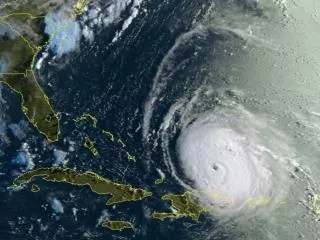
Hurricanes – TEKS 8.10 C. Pamela Esprivalo Harrell UNT. http://www.dannylipford.com/images/article/how-prepare-hurricane-1.jpg. http://www.ssd.noaa.gov/goes/east/tatl/flash-vis.html. http://1.bp.blogspot.com/_cudK8MwW64I/SOS-fn500eI/AAAAAAAAHGo/onP6gsC8R4I/s400/igor.jpg. Engage.

E N D
Hurricanes – TEKS 8.10 C Pamela Esprivalo Harrell UNT http://www.dannylipford.com/images/article/how-prepare-hurricane-1.jpg http://www.ssd.noaa.gov/goes/east/tatl/flash-vis.html http://1.bp.blogspot.com/_cudK8MwW64I/SOS-fn500eI/AAAAAAAAHGo/onP6gsC8R4I/s400/igor.jpg
Engage View the video clip: http://www.youtube.com/watch?v=H9VpwmtnOZc What is a hurricane? 2. How does a hurricane form? What conditions must exist for a hurricane to form?
Explore Objective: Manipulate wind speed, latitude, moisture levels, and temperature to create a hurricane
Procedural Steps • Distribute the Create-a-Cane activity sheet. • Review the instructions.
Procedural Steps • Locate the website. http://www.nhc.noaa.gov/HAW2/pdf/canelab.htm • Note: the “ ” button for helpful information.
Explain What type of wind is needed for a hurricane to form? Low to medium winds, blowing in the same direction (weak wind shear).
2. What is wind shear? Any change in wind speed or direction. When the upper-level, mid-level, and low-level winds are matched (either light to medium) this variable is maximized in terms of hurricane formation.
http://www.noaanews.noaa.gov/stories/images/verticalshear.jpghttp://www.noaanews.noaa.gov/stories/images/verticalshear.jpg
3. What is the range of latitudes in which a hurricane forms? 5-30 degrees North in the ocean and from the equator. http://uemap.com/image/english/world/atlantic.gif
4. What must the ocean surface temperature be for hurricane formation? 26.5º C (> 80ºF). Also, this warm water must extend down in the ocean about 50 meters (~150 feet). http://www.wpclipart.com/science/thermometer_medium.png
5. What must the moisture of the lower and middle atmospheric layer be like to form? It must be very moist in the low and middle levels. The upper layer of the atmosphere may be either dry or moist.
6. Explain how the sea temperature and the atmospheric layers are related in the formation of a hurricane. The oceans must heat up (26.5º C in this simulation). The heating of the ocean causes water (moisture) to escape into the atmosphere and form clouds. Another favorable variable occurs when the vertical wind shear is low or medium.
7. What provides the energy for a hurricane? • As warm air from the warm water rises, clouds are formed. As the warm air rises, it cools and releases energy giving the hurricane its power.
8. What might cause a hurricane to loose its energy? • A change in wind shear, traveling over water of lower temperature, and physical aspects of the land (buildings, hills etc.) will cause the hurricane to lose its energy.
9. Explain the evolution of a hurricane. • It begins as a tropical disturbance. If conditions of moisture, temperature, wind, and geographic location (latitude) are favorable , then it graduates to a tropical depression, a tropical storm, and finally a hurricane.
10. Why are there no hurricanes in Alaska? • The temperature of the water is insufficient to generate hurricanes. Secondly, the distance from the equator makes this geographically impossible.
11. Summarize the role that the ocean plays in the development of a hurricane weather system? • The ocean must become very warm. This moisture must create a very moist atmosphere, which in turn results in cloud formation. If atmospheric winds are low, then a counter-clockwise circulation pattern (due to Corialis Effect) is initiated.
Explain - Vocabulary Tropical Disturbance http://ww2010.atmos.uiuc.edu/%28Gh%29/guides/mtr/hurr/stages.rxml
Tropical Disturbance http://www.filerex.com/screenshots/dart_tropical_islands_vol.1_1.02.2_main_window.jpg http://blogs.citypages.com/blotter/do_not_disturb_sign.jpg
Explain - Vocabulary Tropical Depression http://ww2010.atmos.uiuc.edu/%28Gh%29/guides/mtr/hurr/stages.rxml
http://images.paraorkut.com/img/clipart/images/d/depressed-862.pnghttp://images.paraorkut.com/img/clipart/images/d/depressed-862.png http://www.filerex.com/screenshots/dart_tropical_islands_vol.1_1.02.2_main_window.jpg Tropical Depression
Explain - Vocabulary Tropical Storm http://i.telegraph.co.uk/telegraph/multimedia/archive/00800/palm-trees-motorway_800788i.jpg
Explain - Vocabulary Hurricane http://ww2010.atmos.uiuc.edu/%28Gh%29/guides/mtr/hurr/stages.rxml
Elaborate • Objectives: • Track the path of Hurricane Katrina using latitude and longitude coordinates. • Note changes of wind speed as the hurricane develops. • Determine how sea temperatures affect the hurricane’s strength. • Evaluate what happens to hurricanes strength when it reaches landfall.
Materials Pencil Colored pencils NOAA Hurricane Tracking Map Hurricane Katrina Data Table Lab Activity Handout
Materials Pencil Colored pencils NOAA Hurricane Tracking Map Hurricane Katrina Data Table Lab Activity Handout
1. Based on wind speed, what date and time did Katrina first become a hurricane? • August 25, 2005
2. When did the greatest wind speeds occur? • August 28, 2005 at 6:00 PM
3. Using the data table, what was the longitude and latitude when Katrina reached a level 5 category? • Latitude 25.7o N; Longitude 87.7o W
4. Looking at the diagram below, what were the area sea surface temperatures like when Katrina became a category 5 Hurricane? • Sea Surface Temperatures were warmer.
5. If all variables are favorable, how would increasing sea surface temperatures affect wind speed and strength of the storm? • The warmer water and moisture-rich air would provide more energy; therefore the wind speed and intensity of the storm would increase.
6. When did the wind speeds decrease the fastest? • August 30, 2005
7. As the pressure in Hurricane Katrina got lower or higher, what happened to the wind speed? • Wind Speed increased when pressure was lower and decreased as pressure became higher.
8. What caused Hurricane Katrina to slow to a tropical depression on August 30th? • Moving over cooler water.
9. What happens to the strength of a hurricane as it moves across land? Why does this happen? • The hurricane looses strength, begins to weaken and fall apart. This happens because the hurricane loses its energy source (warm ocean waters).
10. What geographical areas of the United States are prone to being hit by hurricanes? Why? • Gulf Coast states and the Eastern states of the United States are at risk for one or more hurricanes each year. The warmer ocean waters of the Atlantic Ocean and Gulf Coast of Mexico provide the fuel for the energy in the formation of hurricanes.
Evaluate Complete the evaluation.