Download
1 / 21
210 likes | 216 Views
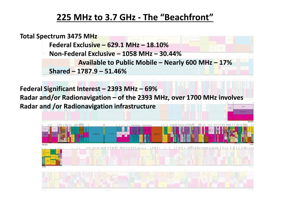
225 MHz to 3.7 GHz - The “Beachfront” Total Spectrum 3475 MHz Federal Exclusive – 629.1 MHz – 18.10% Non-Federal Exclusive – 1058 MHz – 30.44% Available to Public Mobile – Nearly 600 MHz – 17% Shared – 1787.9 – 51.46% Federal Significant Interest – 2393 MHz – 69%

E N D
225 MHz to 3.7 GHz - The “Beachfront” Total Spectrum 3475 MHz Federal Exclusive – 629.1 MHz – 18.10% Non-Federal Exclusive – 1058 MHz – 30.44% Available to Public Mobile – Nearly 600 MHz – 17% Shared – 1787.9 – 51.46% Federal Significant Interest – 2393 MHz – 69% Radar and/or Radionavigation – of the 2393 MHz, over 1700 MHz involves Radar and /or Radionavigation infrastructure
Spectrum with Significant Federal Commitments 225 MHz - 3.7 GHz Does not include passive bands or some very small bands DoD has commitments in every band in this range except the passive bands
225-399.9 MHz This band is a critical military radio communications band that has been preserved for military operations by the North Atlantic Treaty Organization (NATO); and within the individual NATO member countries. The military nature of this band has also been maintained by certain allied and friendly nations outside the NATO alliance such as Australia, Israel, New Zealand, and Saudi Arabia; and by the European Cooperation Partner nations and the Partners for Peace nations. It is vital to military and Coast Guard operations due to its excellent propagation characteristics. The military agencies and the Coast Guard use this band for operational tactical and strategic communications via mobile-satellite systems, especially using small terminals. The system consists of a constellation of eight satellites providing coverage over most of the world, providing communications channels for tactical forces on land, ships, submarines, and aircraft. The satellite downlinks are in the 243.855-269.95 MHz band with the corresponding uplinks in the 292.85-317.325 MHz band. The Coast Guard uses six channels on the military satellites. Over 18,000 earth terminals have been deployed. The Navy uses this band for the next generation UHF satellites, termed the Multiple User Objective System (MUOS). The MUOS will enable communications to various terminal devices such as handhelds, laptops, and personal communications units. The military agencies and the Coast Guard use this band for air-to-ground and air-to-air communication systems for the control of military aircraft, including unmanned aircraft. The Coast Guard uses this band for tactical operations such as ship-to-air and ship-to-ship clear and secure voice communications. The Coast Guard also uses the band for data link communications. The military agencies’ use includes a major tactical radio communications system providing anti-jam, secure, frequency-hopping radio communications system. The system is used for tactical air-to-air, air-to-ground, and ground-to-air communications, including interoperability communications among Air Force, Navy, Army, and NATO units. Over 60,000 radios have been manufactured for this system. The Federal Aviation Administration operates the Instrument Landing System (ILS) Glideslope system in the 328.6-335.4 MHz band. NASA uses this band to provide differential Global Positioning System (GPS) in support of the Space Shuttle Microwave Scanning Beam Landing System (MSBLS). The Federal Aviation Administration uses this band for aeronautical communication systems for the air traffic control of military aircraft. The military agencies use this band for airborne communications networks via multichannel radio relay systems. Air-to-air and air-to-ground modes are used. The National Aeronautics and Space Administration (NASA) uses this band for voice communication related to Space Shuttle operations and air-ground-air communication for flight research and testing communications, including those of the Space Shuttle, and Space Station Extra-Vehicular Activities. The military agencies use selected portions of the 380-399.9 MHz band for trunked land mobile radio communications networks, primarily for non-tactical applications such as military base security.
406.1-420 MHz The federal agencies use this band extensively for conventional and trunked land mobile radio communications systems for law enforcement, security, transportation, natural resources, emergency and disaster, and medical and administrative duties. These systems are used in the protection of the President, and other high-level officials, both U.S. and foreign; promoting public safety and efficiency in traveling via air, water, and land; interdicting entry of illegal persons and substances into the United States; establishing communications between disaster areas and relief forces; ensuring the swift search and rescue of human life; protecting the national forests, parks and farmlands; bringing to justice perpetrators of federal crimes; and ensuring the security of energy generation and distribution networks. In addition, these systems are used for federal emergency response and public safety organizations which conduct large-scale exercises to prepare for and respond to a wide variety of emergencies and disasters, such as hurricanes, earthquakes, and chemical and nuclear power plant accidents. Furthermore, there are specific frequencies in this band that are used by federal agencies to interoperate with State and local public safety agencies for joint law enforcement and incident response operations. The National Science Foundation uses this band for radio astronomy research via continuum observations. . The National Aeronautics and Space Administration uses this band to remotely operate cranes, support unmanned aerial vehicle data requirements and operate systems in support of Extra-Vehicular Activity communications for manned space program. The federal agencies operate systems in the band segments 406.1125-406.1375 , 406.1625-406.1875 and 412.6125-412.6375 MHz for the transmission of hydrologic and meteorological data.
420-450 MHz The Air Force, Army, Navy, and Homeland Security operate ground-based, shipborne, and airborne long-range surveillance radars in this band. These radar systems are used for national security by providing the early warning defense and protection of the borders. The military agencies also operate the Enhanced Position Location System (EPLRS), a major tactical system used to provide critical position location information for ground and air forces. The military agencies have deployed thousands of EPLRS units. The Air Force uses the 449.775-450.25 MHz band for the space telecommand of small experimental satellites called nanosats. The military agencies operate foliage penetration search and surveillance radars in this band. The National Oceanic and Atmospheric Administration uses 449 MHz for the Wind Profiler Radar network that monitors and provides warnings of severe weather conditions through the measurement of wind speed and direction at various altitudes. The National Aeronautics and Space Administration (NASA) and the military agencies use this band for telemetry and telecommand systems. Operations also include test range safety via the command control and flight termination of launched vehicles. NASA uses the 432-438 MHz band for active remote sensing using synthetic aperture radar (SAR) measurements over rain forests and polar ice regions. NASA uses this band for communication between the surface of Mars and spacecraft in orbit around Mars. The Coast Guard uses 433 MHz for radio frequency identification (RFID) for container tracking.
608-614 MHz The National Science Foundation uses this band for radio astronomy research service via continuum observations of pulsars, the Sun, and the planet Jupiter that have enabled scientists to further study the Milky Way galaxy. The Department of Veteran Affairs operates medical telemetry devices in this band used for patient condition monitoring, including coronary patient care telemetry in hospitals and other medical facilities.
902-928 MHz The Navy operates air search and surveillance radar systems onboard ships and aircraft carriers in this band. Propagation characteristics make the band ideal for the detection of fast-moving seaborne targets. The military agencies use this band for tracking radar systems for aeronautical flight-testing. The military agencies use this band to monitor the position of missiles, drones, and manned aircraft. The military agencies use this band for security via perimeter protection systems used for intrusion detection. The National Oceanic and Atmospheric Administration operates the Wind Profiler Radar network that monitors and provides warnings of severe weather conditions through the measurement of wind speed and direction at various altitudes. The Coast Guard uses this band for radio frequency identification (RFID) for Container Tracking and port security.
960-1215 MHz The 960-1215 MHz band is a critical band used for aeronautical radionavigation systems operated by the Federal Aviation Administration (FAA) to control civilian and military aircraft in the National Air Space. The Distance Measuring Equipment (DME) System and its military version, the tactical air navigation (TACAN) operate in the 960-1215 MHz band. DME is usually collocated with a VOR (VOR/DME) to provide the distance and azimuth from the aircraft to the DME transmitter. (The VOR system operates in the 108-118 MHz band.) At some sites, the DME function is provided by the TACAN system which also provides azimuth guidance to military users. The azimuth service of TACAN serves military users whereas the DME serves both military and civil users. The military’s joint VOR and TACAN facilities are called VORTAC stations and are located predominately on military installations in the United States that are available to all users. TACAN also supports Space Shuttle operations. The FAA operates VOR, VOR/DME, and VORTAC systems and DMEs that are collocated with Non-Directional Beacons. The FAA operates these facilities with other Federal agencies, states, local governments, and private entities. The FAA operates the Air Traffic Control Radar Beacon System (ATCRBS) on 1030 MHz and 1090 MHz at stand-alone sites or in conjunction with long-range air traffic control and airport control radars to provide identification and other flight information about the aircraft to facilitate tracking and management by air traffic controllers. The ATCRBS is a Secondary Surveillance Radar (SSR), and consists of a ground-based interrogators and airborne transponders. The system interrogates all transponders in its surveillance area and displays target information such as the aircraft identified and altitude on the flight controller’s radar screen or computer display. The FAA operates the Automatic Dependent Surveillance-Broadcast (ADS-B) system which generates onboard position information from onboard navigation systems, and transmits such position information to the ground. The ADS-B technology consists of the aircraft avionics broadcasting the aircraft position, altitude, velocity, and other parameters autonomously without the need for ground interrogation. Furthermore, no action is required by the pilot who is not involved in initiating the broadcasts. The service is dependent on the aircraft position determination system. The ADS-B operates on 978 MHz and 1090 MHz. The 978 MHz component of ADS-B is to support aircraft equipped with a Universal Access Transceiver (UAT); and the 1090 MHz component of ADS-B is used by aircraft equipped with Mode-S which is predominately-commercial aircraft. UAT is primarily used by general aviation. The two systems are integrated so that UAT and 1090 MHz equipped aircraft receive uplinked information on all aircraft within their geographic area. The FAA operates the Mode Select, or Mode-S system on 1030 MHz and 1090 MHz. Mode-S provides more accurate position information and minimizes interference, reducing the number of transmissions required to obtain the necessary data. FAA operates the Universal Access Transceiver (UAT) and facilitates Automatic Dependent Surveillance–Broadcast (ADS–B) for civil aviation. ADS–B equipped aircraft periodically broadcast their position and intent information to other aircraft and/or ground facilities. The military agencies operate a communications system, the Joint Tactical Information Distribution System (JTIDS) in this band. Also called Link-16, JTIDS is a military system used by U.S. and NATO forces to provide tactical, secure, jam-resistant voice and data communications, transmitting data such as aircraft locations, velocities, headings of friendly and hostile aircraft, and general situation awareness information.
1215-1300 MHz The Federal Aviation Administration (FAA) and the Air Force operate the Joint Surveillance System, fixed site long-range air surveillance and safety-of-flight en-route air traffic control radar systems in this band. These radar systems are used for air-defense, drug interdiction, and air-traffic control. These systems identify and track all aircraft, both commercial and federal. The frequency 1227.6 MHz ± 12 MHz is used to transmit the Global Positioning System (GPS) radionavigation satellite service L2 signal used for military, aviation, space, and commercial applications. The FAA operates ground reference stations used by the Wide Area Augmentation System (WAAS) in this band. The WAASis an air navigation aid that augments the Global Positioning System (GPS), with the goal of improving its accuracy, integrity, and availability. WAAS is intended to enable aircraft to rely on GPS for all phases of flight, including precision approaches to any airport within its coverage area. The Department of Homeland Security operates radar systems mounted on tethered balloons along the southern border of the United States to detect low-flying aircraft in support of drug interdiction programs. NASA operates synthetic aperture radar systems in this band for the measurements of geological surfaces and ocean wave structures. NASA also operates scatterometers in this band to aid in measuring ocean salinity and soil moisture content. The Navy operates shipborne radars in this band for the detection, tracking, identification, threat evaluation, and weapons engagement of high-speed, small cross-section targets.
1300-1390 MHz The Federal Aviation Administration and the Air Force operate long-range air surveillance and safety-of-flight en-route air traffic control radar systems in this band. These radar systems are used for air-defense, drug interdiction, and air-traffic control. These systems identify and track all aircraft, both commercial and federal. The National Science Foundation performs radio astronomy observations redshifted hydrogen spectral lines. NASA uses this band for the passive remote sensing of ocean salinity and soil moisture content. The Navy operates shipborne radars in this band for the detection, tracking, identification, threat evaluation, and weapons engagement of high-speed, small cross-section targets. The military agencies use this band to control unmanned vehicles. The military agencies use this band for fixed and mobile communications links, including tactical systems. The frequency range 1381.05 MHz ± 5 MHz is used by Global Positioning System (GPS) satellites to relay data on the detection of nuclear bursts.
1400-1427 MHz The National Aeronautics and Space Administration (NASA) uses this band for the passive remote sensing of ocean salinity and soil moisture content using passive microwave radiometers. The National Science Foundation uses this band for radio astronomy research via observations of hydrogen lines.
1435-1525 MHz The military agencies and the National Aeronautics and Space Administration operate aeronautical mobile telemetry systems in this band for flight testing of manned and unmanned aircraft, missiles, and space vehicles, and associated communications such as range safety, chase aircraft, and weather data.
1559-1610 MHz The 1575.42 MHz ± 12 MHz frequency is used to transmit the Global Positioning System (GPS) radionavigation-satellite service L1 signal for military, aviation, space, and commercial applications. The Federal Aviation Administration operates ground reference stations used by the Wide Area Augmentation System (WAAS). The WAASis an air navigation aid developed by the Federal Aviation Administration to augment the Global Positioning System (GPS), with the goal of improving its accuracy, integrity, and availability. WAAS is intended to enable aircraft to rely on GPS for all phases of flight, including precision approaches to any airport within its coverage area.
1670-1710 MHz The National Oceanic and Atmospheric Administration (NOAA) and the National Aeronautics and Space Administration operate earth stations used to download environmental research and weather data from the Geosynchronous Operational Environmental Satellite (GOES) and non-geostationary NOAA/TIROS-N meteorological satellites (space-to-Earth). Information is essential for severe storm notification and public safety, and is used daily in TV and radio broadcast weather reporting. The federal agencies conduct radiosonde operations in this band to collect meteorological data for weather forecasting. The radiosonde systems perform altitude-specific measurements of the atmospheric pressure, temperature, relative humidity, and wind speed. The federal agencies operate fixed point-to-point microwave communication systems in the 1700-1710 MHz portion.
1755-1850 MHz This band is used by the military to support operations for numerous important purposes. The Army uses the band for mobile subscriber equipment (MSE), a cellular-like system. In the band 1761-1842 MHz, the Air Force Satellite Control Network and Satellite Ground Link Subsystem (SGLS) perform uplink tracking, telemetry, and telecommand for all of the military geostationary and non-geostationary satellites. The military and other federal agencies use this band for multi-channel or wideband fixed and fixed transportable microwave and tactical radio relay communication systems. The federal agencies operate multi-channel fixed point-to-point medium capacity microwave systems in this band for such purposes as hydroelectric power grid and dam control and air traffic control communication The federal agencies use this band for video surveillance systems for law enforcement, security, and other critical public safety uses. With the relocation of 1710-1755 MHz spectrum to commercial advanced wireless services, the fixed microwave communication systems and video surveillance systems that were formerly using the entire 1710-1850 MHz band are now compressed into the 1755-1850 MHz portion. The military agencies operate ground-based and airborne mobile systems for air-to-ground video telemetry, air combat training systems, guided weapons systems, unmanned aerial vehicles, robotics control, and combat identification. This includes precision guided munitions that were migrated from the 1710-1755 MHz band, The National Aeronautics and Space Administration (NASA) uses this band for Space Shuttle payload interrogation.
2025-2110 MHz The National Aeronautics and Space Administration (NASA) operates their primary telecommand communications used for the control of their spacecraft and those associated with foreign space agency missions. These operations employ uplinks direct from earth stations and forward links via the Tracking and Data Relay Satellite System (TDRSS) which provides links between low earth orbiting spacecraft and earth stations. NASA uses the same spectrum for multiple near space missions. NASA and the National Oceanic and Atmospheric Administration command the Geosynchronous Operational Environmental Satellite (GOES) meteorological satellite system. The GOES system provides important imagery and atmospheric soundings to the National Weather Service (NWS) for their routine use and during periods of severe weather outbreaks when the information is furnished as frequently as once every 8 minutes. The imager and sounder measurements provide meteorological, environmental, and climate data used by the NWS, other federal agencies, and member nations of the World Meteorological Organization. The U.S. National Meteorological Satellite System is composed of two elements consisting of Polar Orbiting Environment Satellite (POES) and the GOES systems. The POES series satellites are polar orbiting and are able to collect global data on a daily basis for a variety of land, ocean, and atmospheric applications. Data from the POES satellites supports a broad range of environmental monitoring applications including weather analysis and forecasting, climate research and prediction, global sea surface temperature measurements, atmospheric soundings of temperature and humidity, ocean dynamics research, volcanic eruption monitoring, forest fire detection, global vegetation analysis, research, search and rescue, and many other applications. The National Polar Orbiting Environment Satellite System (NPOESS) is the follow-on polar weather satellite system replacing the POES and the Defense Meteorological Satellite Program and the Earth Observing System in a converged program. The NPOESS system will collect and disseminate data to a variety of users worldwide. This band is also the primary command and control band for U.S. civil space programs. Systems that use this band include the Tracking and Data Relay Satellite System (TDRSS), the Space Shuttle, the Hubble Space Telescope, and the International Space Station, all operated by the National Aeronautics and Space Administration. The military agencies are pursuing dual band satellites that will operate in this band and 1761-1842 MHz.
2200-2290 MHz The military agencies and the National Aeronautics and Space Administration (NASA) receive tracking, telemetry, and control data communications to control their spacecraft and those of other administrations. These agencies operate systems for space research and Earth exploration services that communicate from earth stations and return links via the Tracking and Data Relay Satellite System (TDRSS) to provide data links between low earth orbiting spacecraft and earth stations. NASA re-uses many of the same frequency bands for its near space missions; and re-uses other bands for their deep space missions. Federal agencies use this band for terrestrial telemetering operations for aircraft, sounding rocket, and missile flight testing. NASA and the National Oceanic and Atmospheric Administration use this band to command and control the Geosynchronous Operational Environmental Satellite (GOES) and polar-orbiting meteorological satellites. The Department of Energy’s Western Area Power Administration (WAPA) uses this band for point-to-point microwave relay communications to support their hydroelectric power grid system in a number of western states.
2360-2395 MHz The Air Force and the National Aeronautics and Space Administration operate aeronautical mobile telemetry systems in this band that are used for the flight-testing of manned and unmanned aircraft, missiles, and space vehicles, and associated communications such as range safety, chase aircraft, and weather data. The National Science Foundation operates a radar in Arecibo, Puerto Rico to explore the surface of planets, explore other solar system bodies and to detect Near Earth Objects. The Arecibo radar transmits and receives in the 2370-2390 MHz band.
2700-2900 MHz The Federal Aviation Administration (FAA), the National Aeronautics and Space Administration (NASA) and military agencies operate fixed site Airport Surveillance Radars (ASRs) in this band as air terminal surveillance radars at airports and military bases for the management and control of aircraft during takeoffs and landings. The FAA incorporates data from the ASRs in the en route environment to enhance their radar coverage, particularly at lower elevations. The National Oceanic and Atmospheric Administration National Weather Service, the military agencies, and the FAA operate the Next-Generation Doppler Radar (NEXRAD) in this band. The meteorological radar detects the presence and intensity of rain, sleet, and snow; determines the speed and direction of wind in storms; and identifies conditions hazardous to aviation. This radar can detect the development of tornados high above earth before they touch down greatly increasing the lead-time for tornado warnings. NASA uses this band for meteorological radars in support of range operations and meteorological research. The National Science Foundation performs radio astronomy observations of the cosmos in this band to study the low galactic background radiation and both the ionized hydrogen clouds and general diffuse radiation of the Galaxy.
2900-3100 MHz This is a major military radar band, used for aircraft surveillance by transportable radars throughout the United States. The Air Force uses this band for a major radar system for air-defense and aeronautical radionavigation. Other military radar applications are artillery and rocket tracking, and test range safety. The Navy and the Coast Guard operate radar systems and positioning aids in this band for maritime radionavigation. The maritime radars provide ships with surface search, navigation capabilities, and tracking services, particularly in foul weather. These radars are used by all categories of commercial and Federal Government vessels, including thousands of foreign and U.S.-flagged cargo, oil tanker and passenger ships operating in U.S. waters, and is a vital sensor for safe navigation of waterways. The Coast Guard operates Vessel Traffic Services in selected harbors with heavy ship traffic. The Vessel Traffic Services systems use maritime radars and shore-based Radar Beacons (RACONs) that operate with shipborne radars to aid navigation. The marine radar system provides indications and data on surface craft, obstructions, buoy markers, and navigation marks to assist in navigation and collision avoidance. The RACONs work with shipborne navigation radar systems to electronically identify maritime obstructions and navigation points. The Coast Guard operates RACONs in this band as required by international treaty. The National Oceanic and Atmospheric Administration, the military agencies, and the Federal Aviation Administration operate the Next-Generation Doppler Radar (NEXRAD) in this band. This radar detects the presence and intensity of rain, sleet, and snow; determines the speed and direction of wind in storms; and identifies conditions hazardous to aviation. This radar can detect the development of tornados high above earth before they touch down greatly increasing the lead-time for tornado warnings. The Navy operates the Cobra Judy shipborne phased-array radar system in this band to provide missile launch data in support of arms control agreements. Federal agencies use this band for public safety site-security radars to limit airspace near critical areas.
3100-3650 MHz This band is critical to military radar operations for national defense. The military agencies operate high-powered defense radar systems on fixed, mobile, shipborne, and airborne platforms in this band. These radar systems are used in conjunction with weapons control systems and for the detection and tracking of air and surface targets. The Navy uses the band for a major radar system on guided missile cruisers, and the Army uses the band for a major firefinder system to detect enemy projectiles. The Navy uses this band for surveillance and precision approach radars to support its air operations. The military agencies operate radar systems used for bomb scoring, battlefield weapon locations, carrier precision approach control, and range safety. The National Aeronautics and Space Administration operates synthetic aperture radars systems in this band for multi-spectral imaging of the earth supporting geodetic and geologic sciences.