Download
1 / 1
10 likes | 279 Views
NATIONAL CENTER FOR EARTH-SURFACE DYNAMICS NCED's purpose is to catalyze development of an integrated, predictive science of the processes shaping the surface of the Earth, in order to transform management of ecosystems, resources, and land use DESKTOP WATERSHED STREAM RESTORATION EDUCATION

E N D
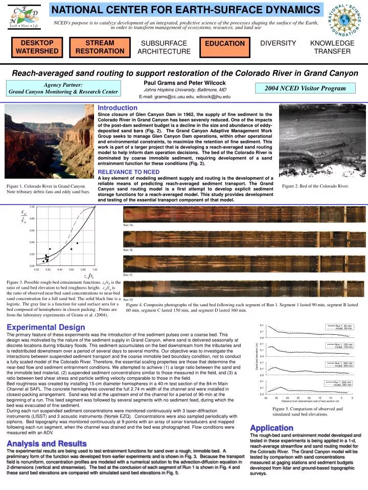
NATIONAL CENTER FOR EARTH-SURFACE DYNAMICS NCED's purpose is to catalyze development of an integrated, predictive science of the processes shaping the surface of the Earth, in order to transform management of ecosystems, resources, and land use DESKTOP WATERSHED STREAM RESTORATION EDUCATION DIVERSITY KNOWLEDGE TRANSFER SUBSURFACE ARCHITECTURE Reach-averaged sand routing to support restoration of the Colorado River in Grand Canyon Paul Grams and Peter Wilcock Johns Hopkins University, Baltimore, MD E-mail: grams@cc.usu.edu, wilcock@jhu.edu Agency Partner: Grand Canyon Monitoring & Research Center 2004 NCED Visitor Program Introduction Since closure of Glen Canyon Dam in 1962, the supply of fine sediment to the Colorado River in Grand Canyon has been severely reduced. One of the impacts of the post-dam sediment budget is a decline in the size and abundance of eddy-deposited sand bars (Fig. 2). The Grand Canyon Adaptive Management Work Group seeks to manage Glen Canyon Dam operations, within other operational and environmental constraints, to maximize the retention of fine sediment. This work is part of a larger project that is developing a reach-averaged sand routing model to help inform dam operation decisions. The bed of the Colorado River is dominated by coarse immobile sediment, requiring development of a sand entrainment function for these conditions (Fig. 2). RELEVANCE TO NCED A key element of modeling sediment supply and routing is the development of a reliable means of predicting reach-averaged sediment transport. The Grand Canyon sand routing model is a first attempt to develop explicit sediment storage functions for a reach-averaged model. This study provides development and testing of the essential transport component of that model. Figure 2. Bed of the Colorado River. Figure 1. Colorado River in Grand Canyon. Note tributary debris fans and eddy sand bars. Figure 3. Possible rough-bed entrainment functions. zs/rb is the ratio of sand bed elevation to bed roughness height. ca/ĉa is the ratio of observed near-bed sand concentrations to near-bed sand concentration for a full sand bed. The solid black line is a logistic. The gray line is a function for sand surface area for a bed composed of hemispheres in closest packing . Points are from the laboratory experiments of Grams et al. (2004). Figure 4. Composite photographs of the sand bed following each segment of Run 1. Segment 1 lasted 90 min, segment B lasted 60 min, segment C lasted 150 min, and segment D lasted 360 min. Experimental Design The primary feature of these experiments was the introduction of fine sediment pulses over a coarse bed. This design was motivated by the nature of the sediment supply in Grand Canyon, where sand is delivered seasonally at discrete locations during tributary floods. This sediment accumulates on the bed downstream from the tributaries and is redistributed downstream over a period of several days to several months. Our objective was to investigate the interactions between suspended sediment transport and the coarse immobile bed boundary condition, not to conduct a fully scaled model of the Colorado River. Therefore, the essential scaling properties are those that determine the near-bed flow and sediment entrainment conditions. We attempted to achieve (1) a large ratio between the sand and the immobile bed material, (2) suspended sediment concentrations similar to those measured in the field, and (3) a ratio between bed shear stress and particle settling velocity comparable to those in the field. Bed roughness was created by installing 15-cm diameter hemispheres in a 40-m test section of the 84-m Main Channel at SAFL. The concrete hemispheres covered the full 2.74 m width of the channel and were installed in closest-packing arrangement. Sand was fed at the upstream end of the channel for a period of 90-min at the beginning of a run. This feed segment was followed by several segments with no sediment feed, during which the bed was evacuated of fine sediment. During each run suspended sediment concentrations were monitored continuously with 3 laser-diffraction instruments (LISST) and 3 acoustic instruments (Nortek EZQ). Concentrations were also sampled periodically with siphons. Bed topography was monitored continuously at 9 points with an array of sonar transducers and mapped following each run segment, when the channel was drained and the bed was photographed. Flow conditions were measured with an ADV. Figure 5. Comparison of observed and simulated sand bed elevations. Application The rough-bed sand entrainment model developed and tested in these experiments is being applied in a 1-d, reach-average streamflow and sand routing model for the Colorado River. The Grand Canyon model will be tested by comparison with sand concentrations measured at gaging stations and sediment budgets developed from lidar and ground-based topographic surveys. Analysis and Results The experimental results are being used to test entrainment functions for sand over a rough, immoble bed. A preliminary form of the function was developed from earlier experiments and is shown in Fig. 3. Because the transport field is nonuniform, concentration profiles are modeled with a numerical solution to the advection-diffusion equation in 2-dimensions (vertical and streamwise). The bed at the conclusion of each segment of Run 1 is shown in Fig. 4 and these sand bed elevations are compared with simulated sand bed elevations in Fig. 5.