Download
1 / 27
290 likes | 601 Views
JMA Global Model. Hiromi Owada Numerical Prediction Division, Forecast Dept. Japan Meteorological Agency e-mail: howada@naps.kishou.go.jp. Contents. JMA Global Spectral Model (GSM) Overview of GSM Model performance Ensemble Prediction System (EPS) One-week EPS (WEPS) Typhoon EPS (TEPS)

E N D
JMA Global Model Hiromi Owada Numerical Prediction Division, Forecast Dept. Japan Meteorological Agency e-mail: howada@naps.kishou.go.jp
Contents • JMA Global Spectral Model (GSM) • Overview of GSM • Model performance • Ensemble Prediction System (EPS) • One-week EPS (WEPS) • Typhoon EPS (TEPS) • Model products • Deterministic forecast products • EPS products • GIFS-TIGGE products • Early warning products for extreme weather events 2
Current NWP models of NPD/JMA 3 As of 28 March, 2013
Main Operational NWP Systems at JMA • Regional NWP system • Horizontal Resolution: 5 km • Updates: 8 times a day • Forecast domain: • Japan and its surrounding areas • Global NWP system • Horizontal Resolution: 20 km • Updates: 4 times a day • Forecast domain:Global 4
Roles of GSM • basic information for short-range and one week forecasts • basic information for typhoon track and intensity forecasts • assist of aviation and ship routing forecasts • provision of lateral boundary condition for Meso-Scale Model • input data for ocean wave model and regional storm surge model • wind information for input of chemical transport model
NWP models in the world As of 28 March, 2013
Data Assimilation & Forecast The First Guess The last forecast Data Assimilation NWP forecast Initial Condition The next forecast In the DA system, the given model state (first guess) is corrected using various observations informationwith the constraints in the NWP model. In the “cyclic operation”, the first guess is the forecast from the latest DA result. Increment Various Observations
Observations used in JMA NWP Upper air sounding (Image : JMA) Wind profiler (image : JMA) Buoy (image : JMA) Land surface observation (image : JMA) Doppler radar (image : JMA) Typhoon bogus GPS (image : JMA) Sea surface observation (image : JMA) Remote sensing Bogus Direct observations Aviation METEOSAT (image : ESA) DMSP (image : NASA NOAA (image : NOAA) Metop (image : ESA) Semi-operational MTSAT (image : JMA) COSMIC (image : UCAR) GRACE-A (image : NASA) Aqua (image : NASA TRMM (image : NASA GRACE Earth-observing sat. GNSS RO GOES (image : NOAA) Terra (image : NASA GEO satellites LEO satellites 8
Data used in DA SYNOP:N=16819 SHIP:N=3803 BUOY:N=6245 ALL:N=14221 ALL:N=11084 TEMP:N=626 PILOT:N=319 WPROF:N=1864 ALL:N=21577 ALL:N=25796 AVIA:N=43853 ASCAT:N=5939 ALL:N=161778 ALL:N=11852 ALL:N=18278
Necessity of typhoon bogus • It is important to analyze TC correctly for accurate forecast. • Different initial fields yield different forecast results. • Location, size, intensity, … • In many cases, observational data do not exist around a TC to represent its structure properly (A TC locates in the ocean). • Therefore, pseudo-observational data generated based on position and intensity analyzed by forecasters is used.
Verification Score RMSE of 500 hPa geopotential height in Northern Hemisphere (20-90N) (bar: annual mean) The accuracy of 72hr forecast in 2012 compares with that of 24hr forecast in 1980’s. Smaller error 72hour 24hour
GSM RMSE Sequence on Z500 for 120 hrs forecast at N.H. Revision of cumulus parameterization Revision of cumulus parameterization Revision of cloud T213L30 Direct use of ATOVS 3D-Var T213L40 Use of QuikSCAT Use of MODIS Revision of radiation Variational bias correction Revision of VarBC TL319L40 Use of SSM/I and TMI Use of CSR 4D-Var • TL959L60 • Reduced Grid Revision of stratocumulus cloud scheme • TL959L60 Use of COSMIC Revision of GNSS RO usage Use of SSMIS, Use of ASCAT TL319(Inner loop) As of March 2013
Probabilistic Forecast The error grows rapidly With the integration, the deterministic forecast has large error Truth Atmospheric State Forecast Forecast Time With the probabilistic forecast, we could know the confidence information of the forecast. Very small initial error Atmospheric State The range of initial error Forecast Time Color shows probability
Ensemble Prediction Systems • In the EPS, the multiple forecasts are conducted using slightly different initial conditions and/or different forecast settings. • This is a form of Monte Carlo analysis. Forecast time Initial Condition FT48 FT120 FT216 Perturbations in the initial condition are very small Spaghetti diagram [51-member Pmsl forecasts] Perturbations in the 9-days forecast are quite large.
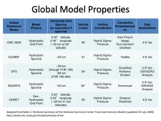
Ensemble Prediction Systems As of 28 March, 2013
JMA One-week Ensemble Prediction System …… • One-week Ensemble Prediction System ( outline ) • 51 members forecast run. • 264 hour forecast (12 UTC initial) is operated everyday. • Horizontal resolution is 0.5625 deg 50 + 1 = 51 global predictions for one ensemble forecast starting at one initial time.
Typhoon Ensemble Prediction System • For 5-day typhoon track forecast • 6hourly, 11member, 132hours forecast • Used in typhoon track probability forecast Strike Probability Map Relatively Low Risk GSM Best Track Higher Risk Ensemble Mean TEPS typhoon track forecasts of All the ensemble members Typhoon track forecast of GSM TEPS probability information
JMA High-Resolution GSMData Service • Target: NMHSs • Mainly in WMO Region II • Model: GSM(TL959) • Data Format: GRIB2 • Preservation Term: Latest 9 days
GSM products on WIS Portal • JMA DDB server discontinued operation at the end of February, 2013. • GSM products continue to be available through a new server at http://www.wis-jma.go.jp • MITIGATION GUIDE FOR DDB USERS is at: http://www.wis-jma.go.jp/cms/wp-content/uploads/2012/09/MigrationGuide_DDB_ver1.pdf • Changes from DDB • How to download GSM products from the new server?
JMA SWFDP webpage • URL: http://www.wis-jma.go.jp/swfdp/ • Products • Deterministic Forecast from Global Model • Probabilistic Forecast from Global medium-range EPS • MTSAT Products • TIGGE Products • Products for the past 10 days are available.
JMA EPS-WEB • operated as a part of a pilot project of JMA aiming at improving the EPS and increasing the availability of its products. • provides the visualized EPS product for supporting the activity of National Meteorological and Hydrological Services (NMHSs) in Asia.
Summary • The outline of JMA Global Spectral Model (GSM) was introduced. With its high resolution, GSM supports short- to medium-range forecasts, typhoon (track and intensity) forecast. • The “forecast confidence information” is important for the disaster risk management. To provide such information, JMA operates One-week EPS (WEPS) and Typhoon EPS (TEPS). • Forecast products available to NMHSs in SeA are introduced. • High-Resolution GSM Data Service, JMA webpage for SWFDP, etc.
References • Japan Meteorological Agency, 2013, Outline of the Operational Numerical Weather Prediction at the Japan Meteorological Agency.