Download
1 / 25
250 likes | 374 Views
McMurdo Ground Station Workshop NPOESS Direct Readout March 10, 2004. DRL Roadmap to NPP and Beyond. NPOESS Program Schedule. Reliable and timely collection, delivery, and processing of quality environmental data. 2002 A&O Contract Award 2003 NPP Critical Design Review 2005

E N D
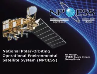
McMurdo Ground Station WorkshopNPOESS Direct ReadoutMarch 10, 2004
NPOESS Program Schedule Reliable and timely collection, delivery, and processing of quality environmental data 2002 A&O Contract Award 2003 NPP Critical Design Review 2005 NPOESS Preliminary Design Review 2006 NPOESS Critical Design Review NPP Ground Readiness NPP Launch Field Terminal Technical Specification 2007 NPP HRD Demonstration 2010 NPOESS Ground Readiness NPOESS C-1 Launch NPOESS HRD/LRD Demonstration
Direct Readout Software Production Schedule You are here
Fully Integrated System Architecture for Optimal Mission Performance Data Del Data Del Data Del Data Del Cal/Val Cal/Val Cal/Val Cal/Val Process Process Process Process Infra Infra Infra Infra Data Mgt Data Mgt Data Mgt Data Mgt Ingest Ingest Ingest Ingest TDRSS TDRSS GPS SpaceSegment ADCS NPP (1030) NPOESSSpacecraft 1330 1730 2130 Residuals SARSAT Svalbard Primary T&C NPP SMD C3Segment White Sands Complex LEO & A Backup T&C HRD Field Terminal LRD FieldTerminal FieldTerminal Segment CLASS ADS SDS NAVO FNMOC AFWA NESDIS 15 Globally DistributedReceptor Sites Interconnectedby Commercial Fiber * * Patent Pending Interface Data Processing Segment Launch SupportSegment Schriever MMC Contingency Operations Team MMC at Suitland Flight Operations Team • Enterprise Management • Mission Management • Satellite Operations • Data Monitoring & Recovery One full set resides in each of the 4 Centrals Data Handling Node, Front End Processor One full set resides in each of the 4 Centrals NPOESS Stored Mission Data NPP Stored Mission Data Command and Telemetry 5
CONOPS Delivers Timely and Reliable Data MMC (Suitland) Schriever MMC 1. Sense Phenomena 2. Downlink Mission Data TSKY TOBS TATM LCL LATM LRN FOG High Rate Data & Low Rate Data Direct Readout Terminals eij Monitor and Control Satellites and Ground Elements 6
NPOESS / NPP Sensor Manifest 1330 - NPOESS 1730 - NPOESS 2130 - NPOESS 1030 - NPP VIIRS VIIRS VIIRS VIIRS CMIS CMIS CMIS CrIS CrIS CrIS ATMS ATMS ATMS SESS GPSOS SS SS SS SARSAT SARSAT SARSAT ADCS ADCS CERES ERBS OMPS OMPS ALT APS TSIS
Field Terminals are an integral part of NPOESS IDP @ Centrals Field Terminal Software SMD SMD Centrals Centrals C3S C3S IDP IDP Space Vehicle 3 Space Vehicle 3 Users Users @ @ C3S C3S CONUS CONUS Centrals Centrals SMD SMD DHN & DHN & Gateways Gateways Ground Ground Space Vehicle 2 Space Vehicle 2 FEP FEP (4x) (4x) Science Science Receptor Receptor Space Vehicle 1 Space Vehicle 1 (@ IDPS) (@ IDPS) Users Users Mission Mission Ground Ground Bus Bus Sensors Sensors Management Management Station Station Deliver Data Deliver Data Center Center IDPS IDPS Products Products Stored Mission Data flow for Stored Mission Data flow for Centrals, Science Users Centrals, Science Users HRD HRD Regional Field Field LRD LRD Terminal Terminal Users Users Software Software Deliver Data Deliver Data Products Products Field Terminals (LRD, HRD) Field Terminals (LRD, HRD) HRD, LRD Data flow for HRD, LRD Data flow for SARSAT, ADCS SARSAT, ADCS Tactical Users Regional Users Terminals Terminals
Field Terminal Segment Architecture NPOESS HRD or LRD NPP HRD Signal Processing Subsystem (SPS) Data Processor Element (DPE) Mission Application Subsystem (MAS) FT Technical Specification Field Terminal Segment Internet Mission Support Data Server
NPOESS Field Terminal Proposed Link Parameters ParameterHigh Rate DataLow Rate Data Carrier Frequency 7812 MHz 1704 MHz Max Occupied 30.8 MHz 12.0 MHz Bandwidth Channel Data Rate* 40 Mbps 11.64 Mbps Ground Aperture Size <= 2.0 meters 1.0 meters Minimum Elevation Angle 5.0 degrees 5.0 degrees * Includes all CCSDS overhead, Reed-Solomon forward error correction, and convolutional encoding
NPOESS Stored Mission Data (SMD)Environmental Data Records (EDRs) VIIRS CMIS CrIS/ATMS OMPS SES GPSOS ERBS TSIS ALT APS 25 19 3 1 13 2 5 1 3 4 EDRs with Key Performance Parameters Ozone; Total Column/Profile Atm Vertical Temp Profile Cloud Top Height Atm Vertical Moisture Profile Cloud Top Pressure Precipitable Water Precipitation Type/Rate Cloud Top Temperature Sea Surface Temperature Sea Surface Winds Downward LW Radiance (Sfc) Pressure (Surface/Profile) Soil Moisture Downward SW Radiance(Sfc) Sea Ice Characterization Imagery Electric Field Sea Surface Height/Topo. Electron Density Profile Snow Cover/Depth Active Fires Aerosol Optical Thickness Energetic Ions Solar Irradiance Aerosol Particle Size Geomagnetic Field Supra-Thermal-Auroral Part. Aerosol Refractive Index Ice Surface Temperature Surface Type Surface Wind Stress Albedo (Surface) In-situ Plasma Fluctuations Auroral Boundary In-situ Plasma Temperature Suspended Matter Ionospheric Scintillation Auroral Energy Deposition Total Water Content Auroral Imagery Medium Energy Charged Particles Vegetation Index Cloud Base Height Land Surface Temperature Cloud Cover/Layers Net Heat Flux Cloud Effective Particle Size Net Solar Radiation (TOA) Cloud Ice Water Path Neutral Density Profile Cloud Liquid Water Ocean Color/Chlorophyll Cloud Optical Thickness Ocean Wave Characteristics Cloud Particle Size/Distribution Outgoing LW Radiation (TOA)
NPOESS High Rate Data (HRD)Environmental Data Records (EDRs) VIIRS CMIS CrIS/ATMS OMPS SES GPSOS ERBS TSIS ALT APS 25 19 3 1 13 2 5 1 3 4 EDRs with Key Performance Parameters Ozone; Total Column/Profile Atm Vertical Temp Profile Cloud Top Height Atm Vertical Moisture Profile Cloud Top Pressure Precipitable Water Precipitation Type/Rate Cloud Top Temperature Sea Surface Temperature Sea Surface Winds Downward LW Radiance (Sfc) Pressure (Surface/Profile) Soil Moisture Downward SW Radiance(Sfc) Sea Ice Characterization Imagery Electric Field Sea Surface Height/Topo. Electron Density Profile Snow Cover/Depth Active Fires Aerosol Optical Thickness Energetic Ions Solar Irradiance Aerosol Particle Size Geomagnetic Field Supra-Thermal-Auroral Part. Aerosol Refractive Index Ice Surface Temperature Surface Type Surface Wind Stress Albedo (Surface) In-situ Plasma Fluctuations Auroral Boundary In-situ Plasma Temperature Suspended Matter Ionospheric Scintillation Auroral Energy Deposition Total Water Content Auroral Imagery Medium Energy Charged Particles Vegetation Index Cloud Base Height Land Surface Temperature Cloud Cover/Layers Net Heat Flux Cloud Effective Particle Size Net Solar Radiation (TOA) Cloud Ice Water Path Neutral Density Profile Cloud Liquid Water Ocean Color/Chlorophyll Cloud Optical Thickness Ocean Wave Characteristics Cloud Particle Size/Distribution Outgoing LW Radiation (TOA)
NPOESS Low Rate Data (LRD)Environmental Data Records (EDRs) VIIRS CMIS CrIS/ATMS OMPS SES GPSOS ERBS TSIS ALT APS 25 19 3 1 13 2 5 1 3 4 EDRs with Key Performance Parameters Ozone; Total Column/Profile Atm Vertical Temp Profile Cloud Top Height Atm Vertical Moisture Profile Cloud Top Pressure Precipitable Water Precipitation Type/Rate Cloud Top Temperature Sea Surface Temperature Sea Surface Winds Downward LW Radiance (Sfc) Pressure (Surface/Profile) Soil Moisture Downward SW Radiance(Sfc) Sea Ice Characterization Imagery Electric Field Sea Surface Height/Topo. Electron Density Profile Snow Cover/Depth Active Fires Aerosol Optical Thickness Energetic Ions Solar Irradiance Aerosol Particle Size Geomagnetic Field Supra-Thermal-Auroral Part. Aerosol Refractive Index Ice Surface Temperature Surface Type Surface Wind Stress Albedo (Surface) In-situ Plasma Fluctuations Auroral Boundary In-situ Plasma Temperature Suspended Matter Ionospheric Scintillation Auroral Energy Deposition Total Water Content Auroral Imagery Medium Energy Charged Particles Vegetation Index Cloud Base Height Land Surface Temperature Cloud Cover/Layers Net Heat Flux Cloud Effective Particle Size Net Solar Radiation (TOA) Cloud Ice Water Path Neutral Density Profile Cloud Liquid Water Ocean Color/Chlorophyll Cloud Optical Thickness Ocean Wave Characteristics Cloud Particle Size/Distribution Outgoing LW Radiation (TOA)
Excellent EDR Performance for HRD 128 attributes above, 724 at, 9 below threshold Attributes better than TRD threshold Attributes at TRD threshold Attributes below TRD threshold 70 Total 9 Better 0 Below 126 Total 27 Better 2 Below Land EDRs (5) Key EDRs (6) 98 Total 11 Better 2 Below Ocean Water EDRs (7) 155 Total 13 Better 1 Below Atmospheric EDRs (9) Space Environment EDRs (13) 149 Total 43 Better 2 Below 197 Total 17 Better 2 Below Cloud EDRs (10) Total attributes = 861 120 attributes above, 738 at, 10 below threshold
LRD Performance Approaches Objective Levels 305 attributes above, 180 at, 0 below threshold Attributes at or above TRD objective Attributes between TRD threshold & objective No attributes are below TRD threshold High Priority EDRs (8) Lower Priority EDRs (15) 164 Total Attributes 121 Meet Objective Supporting EDRs (5) 249Total Attributes 143 Meet Objective 72Total Attributes 41 Meet Objective Total attributes = 485
Our LRD Approach Balances Performance and Provides Flexibility 3.88 Mbps Limited LRD Bandwidth Selection of compression applied to selected VIIRS mission data for increased mission data throughput in downlink 1330 & 2130 1730 VIIRS CMIS CrIS Programmable LRD downlink provides flexibility for the future
Key Field Terminal Performance Requirements • Key performance requirements govern the attributes of the aperture, RF front-end and demodulator • “Processing” requirements (e.g., decoding) can be viewed as “functional” requirements • LRD aperture requirements: • 1-meter diameter • Aperture/RF front-end requirements: • G/T, passband amplitude and phase response (components of implementation loss) • RF front-end/demodulator requirements: • Implementation loss (covering passband response, phase noise, demodulator performance with respect to theory, et al) • Link budget entries serve as starting points for these requirement values • Requirements are not independent, trade-offs exist
All EDR Production Timing for Field Terminal Configurations 15 Minute Requirement (3 S/C over 3 ½ days)
Field Terminal Data Processor Element Software Design • Open Systems Group standards compliance at interfaces minimizes configurations • Programmable LRD downlink favors 8 Priority EDRs • Onboard VIIRS data compression rates by APID for LRD • Flexible ancillary data approach • Dynamic ancillary data via satellite downlink • NPOESS Mission Support Data Server via Internet access
FTS EDR Performance • HRD EDR Performance • 99% of performance attributes meet or exceed performance thresholds • Latency requirements achievable with current COTS workstations • Designed to recognize missing channels and ancillary data • Lossless RICE compression on VIIRS • LRD EDR Performance • 0.8 km resolution imagery and programmable downlink • Produces 8 high priority EDRs at or near LRD objective levels • Produces 15 lower priority EDRs and required predecessor EDRs • Designed to recognize missing channels and ancillary data • Lossless and Lossy JPEG2000 compression on selected APIDs
Field Terminal Ancillary Data Approach • Dynamic Ancillary Data contained within LRD and HRD downlinks to meet specified performance levels • Data for six elevation levels from the NWP Forecast model • Temperature • Humidity • Surface Pressure • Standard Pressure Levels • Wind Speed, Wind Direction • Precipitable Water • For SESS EDR production • Effective Sunspot Number and Global Geomagnetic Kp • NPOESS Mission Support Data Server, accessible via Internet • Contains full set of Official Ancillary data • Contains full set of NPOESS Auxiliary data • Contains System status bulletins • Satellite vector information for antenna pointing and signal acquisition
Ancillary Data DownlinkGraphical Representations • 16 points spaced 200 kilometers apart at right angles to the ground track • Completely covers the area viewed by all sensors • Successive lines 200 kilometers apart • Each line transmitted twice to ensure receipt by the ground Path of the satellite
What is NPOESS planning? • NPOESS responsible for building software and terminal specifications, but not for building terminals • NPOESS to publish specifications and design trade information • NPOESS DPE software available on the program website for download • NPOESS to deliver data to users world-wide in accordance with U.S. National data policy • Mission data downlinked around the world at no cost to receivers • Data encryption/data denial capability exists for U.S. National defense • Denial can be done on a world-wide or geographic basis
NPOESS Points of Contact • Field Terminal IPT • John Overton: (301) 713-4747 • Bill Munley: (301) 713-4782 • Joe Mulligan: (301) 713-4803 • John van de Wouw: (310) 812-0800 • NPOESS Websites • http://www.npoess.noaa.gov • http://npoesslib.ipo.noaa.gov/ (electronic bulletin board)