Download
1 / 31
310 likes | 453 Views
OneGeology INPIRE, GEOSS, AEGOS An EuroGeoSurveys perspective . OneGeology launch – Brighton (UK) – March 12-16, 2007 Dr. Patrice Christmann , Secretary General, EuroGeoSurveys p.christmann@eurogeosurveys.org Tel.: +3225015332. Welcome to the global Geological spatial Information

E N D
OneGeologyINPIRE, GEOSS, AEGOSAn EuroGeoSurveys perspective OneGeologylaunch – Brighton (UK) – March 12-16, 2007 Dr. Patrice Christmann, Secretary General, EuroGeoSurveys p.christmann@eurogeosurveys.org Tel.: +3225015332
Welcome to the global Geological spatial Information infrastructure
Outline • Two challenges for the Geological Community • Towards an European Spatial Information Infrastucture (INSPIRE) • Towards a Global Earth Observation System of Systems (GEOSS) • The Africa-EU Georesources Observation System initiative (AEGOS)
Our environmental perception remainswidely 2.5 D as thisis the world we candirectly observe but… ? ? ? ?
… the understanding, use and management of the 3rd dimension iscritical to sustainabledevelopment. why ?
Pressures Services Hazards Economic development & Competitiveness + Social well-being, Including health and security Space 2050: 9 billion humans, mostly in yetunderdevelopped countries Minerals Trace elements Soils Hazards Geology and geology-derived data, information and knowledge are keys to Sustainable Development Groundwater Energy
The situation of Geological Spatial Information today: the information puzzle … where even the elements of the puzzle are hard to locate !
? ? ? ? ? ? I wish I would at least know, in my language what data/ information is available…
Meeting the challenge: develop interoperable spatial data sets, based on common data specifications, documented with metadata catalogues, with schematic interoperability Multilingual Metadata: • What ? • Where ? • Scale ? • Who ? • When ? • How ? • Format ? • Quality? • Access conditions ? • … Geosciences for global sustainable development
In the long term: achieve, at least atsmall-scale, semantic and geometricinteroperability and develop 3D models Multilingual metadata: • What ? • Where ? • Scale ? • Who ? • When ? • How ? • Format ? • Quality? • Access conditions ? • … Source: H. Thorleyfson, Association of American State Geologists Geosciences for global sustainable development
WORLD: GLOBAL EARTH OBSERVATION SYSTEM OF SYSTEMS UNESCO CGMW ICOGS Other Geological Survey Organisations Developing Countries (AFRICA: AEGOS) FP7 FP7 EU Dev. Fund & FP7 & bilateral INTEROPERABILITY CAPACITY BUILDING IUGS / CGI IUGS / CGI Europ. Dev. Fund & FP7 EUROPE INSPIRE Interoperability & Harmonisation Standards GMES 12 EuroGeoSurveys Members
Towards an European Spatial Information Infrastructure (INSPIRE)
INSPIRE and its goals • INSPIRE is a European Directive that will enter into force in the coming weeks. • European Directives beeing superior to national law, EU Member States will have to transpose INSPIRE to their national legislation. They have two years to achieve this. • It sets legally binding rules for the establishment of the EU common, shared, distributed, multiligual, interoperable Infrastructure for Spatial Information together with the provision of services for the purposes of Community environmental policies and policies or activities which may have an impact on the environment.
INSPIRE: What spatial information? • INSPIRE covers 35 Spatial Data Themes laid down in 3 Annexes • These themes are required to successfully build environmental information systems • Geology/ groundwater are given a high priority
INSPIRE Elements • METADATA • INTEROPERABILITY OF SPATIAL DATA SETS AND SERVICES • NETWORK SERVICES (Discovery, Transform, View, Download, Invoke) • DATA SHARING • COORDINATION AND COMPLEMENTARY MEASURES – Monitoring & Reporting
INSPIRE METADATA It shall as a minimum entail the search for « data » based on: • (a) keywords; • (b) classification of spatial data and services; • (c) the quality and validity of spatial data sets; • (d) geographical location; • (e) conditions applying to the access to and use of spatial data sets and services; • (f) the public authorities responsible for the establishment, management, maintenance
INSPIRE DIRECTIVE IMPLEMENTATION MILESTONES
Information: http://www.ec-gis.org/inspire/
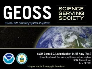
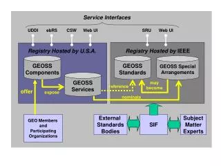
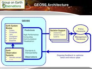
Towards theGlobal Earth Observation System of Systems (GEOSS)
GEOSS • In February 2005 the 10-years implementation plan was approved • It builds on and adds value to existing Earth observation systems by coordinating their efforts, addressing critical gaps, supporting their interoperability, sharing information, reaching a common understanding of user requirements and improving delivery of information to users.
GEOSS Purpose GEOSS will meet the need for timely, quality long-term global information as a basis for sound decision making, and will enhance delivery of benefits to society in the following initial areas: • Reducing loss of life and property from natural and human-induced disasters; • Understanding environmental factors affecting human health and well-being; • Improving management of energy resources; • Understanding, assessing, predicting, mitigating, and adapting to climate variability and change; • Improving water resource management through better understanding of the water cycle; • Improving weather information, forecasting, and warning; • Improving the management and protection of terrestrial, coastal, and marine ecosystems; • Supporting sustainable agriculture and combating desertification; • • Understanding, monitoring, and conserving biodiversity.
GEOSS GOVERNANCE • GEOSS is steered by the Plenary Assembly of the Group on Earth Observation (GEO) Member Countries. Participating Organisations are observers, but intervene in the discussions • GEO has 4 co-chairs: China, European Commission, USA and South Africa. It has an Executive Committee of 12 Members (EU: Commission, Italy (APAT) and Germany) • The implementation of its Work Plan is steered by Standing Committees on Capacity Building, Data & Architecture, Science & Technology and User Interface Committees. There also is a Working Group on Tsunami Activities. EuroGeoSurveys is represented in all of these.
GEOSS and OneGEOLOGY • OneGeology as it develops, based on the outputs of the IUGS CGI work on multilingual thesauri and interoperability, could/ should be shown as a major contribution of the global geological community • Idea: propose to the EuroGeoSurveys General meeting that the EGS boot at the forthcoming GEO plenary and ministerial meeting in Capetown (November) displays OneGeology
The Africa (ACP) – EU Georesources Observation SystemInitiative (AEGOS)
Why AEGOS? • Many Africa Caribbean Pacific (ACP) Group of States, and in particular in Africa, suffer from poverty and underdevelopment. • The sustainable use of natural resources is a key for the development of these countries and for the future of the world, requiring knowledge, based on data, information and expertise. • Resources issues will play an ever increasing role due to the growing world population, rapid urban development and demand for better infrastructure and services. • Availability, traceability, accessibility and user-oriented GIS based processing of heterogeneous data from multiple sources on these resources is essential to sustainable development
AEGOS: issues to beaddressed • Overcome the current dissemination of data assets and the hazards threatening some • Turn paper-based data assets into digital maps and information layers • Strengthen human and technical capacities necessary to turn data into information and expertise required by a wide-range of end-users • Addressing these issues is of importance to the geological community and for its visibility in international undertakings such as GEOSS
AEGOS deliverables • A shared, distributed, interoperable, open information system on geology and geological resources based on Internet technologies • Identification, cataloging, digitisation and georeferencing of existing public data • Provision of access, according to individual partners rules, to public digital data and information • Development of interoperable harmonised (at the level of schematic interoperability) digital layers at regional/ continental scales targeted at end-uses • Development of decision aiding systems for the sustainable use of georesources • Capacity building
AEGOS Implementation • Two phases: • Phase I FP 7 Coordination Action (2 years, possible start early 2008): develop the partnership network, agree on IPR issues, identify user requirements, define the interoperability arrangements and the architecture of the system, define its governance bodies, define and sign a project charter, identify the requirements (tasks, resources, organisation, milestones, deliverables) of the phase II. Proposal in preparation, to be submitted in May. • Phase II: Implementation (4 years, possible start in 2010-2011)
AEGOS promoters(15/03/07) • Council for Geoscience of South Africa (CGS) • Geological Survey of Angola • Geological survey of Ethiopia • Geological Survey of Namibia • Geological Survey of Uganda • Southern and Eastern Mineral Resources Centre, Tanzania (SEAMIC) • BEAK (Germany) • Belgian Geological Survey (SGB, Belgium) • Belgian Royal Museum for Central Africa (RMCA, Belgium) • British Geological Survey (BGS, UK) • Czech Geological Survey (CGS, Czech Republic); • Finnish Geological Survey (GTK, Finland); • French Geological Survey (BRGM, France, Coordinator); • Institute for Research and Development (IRD, France) • German Federal Institute for Geoscience and Natural Resources (BGR, Germany); • Polish Geological Survey (PGI, Poland); • Geosciences Area of the Portuguese Institute for Engineering, Technology and Innovation (INETI, Portugal ); • Geological Survey of Slovenia (GEO-ZS, Slovenia) • Spanish Institute for Geology and Mining (IGME, Spain) • Geological Survey of Sweden (SGU, Sweden)
Using these drivers to there Let’s go from here AEGOS CEN EUROGEOSURVEYS GEOSS ICOGS INSPIRE ISO IUGS/ CGI OGC OneGEOLOGY UNESCO/CGMW Thank you, drivers ! National standards, historical and local practices