Download
1 / 14
140 likes | 161 Views
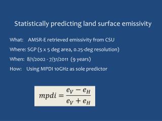
MODIS Collection 5 Workshop, University of Maryland. MODIS Land Surface Temperature and Emissivity Algorithms and Products Zhengming Wan University of California, Santa Barbara January 17-18, 2007. Basic Considerations in MODIS LST Algorithms.

E N D
MODIS Collection 5 Workshop, University of Maryland MODIS Land Surface Temperature and Emissivity Algorithms and Products Zhengming Wan University of California, Santa Barbara January 17-18, 2007
Basic Considerations in MODIS LST Algorithms 1. LST is retrieved from TIR data only in clear-sky conditions. LST is not mixed with cloud-top temperature in the atmospheric product (TIR signal from surface cannot penetrate clouds to reach satellites). 2. LST is defined by the radiation emitted by the land surface observed by MODIS at the instantaneous viewing angle. Applications may need LST at different angles (nadir or 50o from nadir). 3. Proper resolving of the land-atmosphere coupling is the key in retrieving surface & atmospheric properties. Integrated retrieval is possible but it takes a lot of computing time. Use multi-bands in the atmospheric windows for the LST retrieval. The values of atmospheric temperature and water vapor are useful to improve the LST retrieval. However, there may be large errors in these values. Use them as indicates of ranges or initial guesses only. 4. Input data: MOD021KM, MOD03, MOD07, MOD10, MOD12, MOD35 & MOD43.
MODIS LST Algorithms (1) The generalized split-window algorithm (Wan and Dozier, 1996) in form 1 – ε ε Δε ε2 T11µ+ T12µ 2 Ts = C + ( A1 + A2+ A3 ) + ( B1+ B2 +B3) 1 – ε ε Δε ε2 T11µ – T12µ 2 where ε = 0.5 ( ε11µ +ε12µ ) and Δε = ε11µ ־ ε12µ - emissivities estimated from land cover types (Snyder et al., 1998; Snyder & Wan, 1998). Emissivities vary even within a land cover type (crop lands may have different soils and crops in variable coverage). A MODIS pixel may cover several 1km grids with different land cover types. - coefficients Ai, Bi, and C depend on viewing zenith angle (in range of 0-65o). - coefficients also depend on ranges of the air surface temperature and column water vapor. - only process pixels in clear-sky at different MOD35 confidences over land or in lakes.
MODIS LST Algorithms(2) The generalized split-window algorithm (continue) The coefficients were obtained from regression analysis of the MODIS simulation data created by atmospheric radiative transfer code MODTRAN4 in wide ranges of surface and atmospheric conditions. As a thumb rule, regression models work well only within the space that is covered by the data participated in the regression analysis, their performance may degrade near the boundary, and they perform poorly outside the space. An accurate split-window LST algorithm may be developed only if the simulation data are in good quality and they cover a simulation space wider than the real physical space of the surface emissivity/temperature changes, and the atmospheric temperature and water vapor changes. The above statements also apply to a sub-space. There should be enough overlaps between sub-spaces in order to reduce the sensitivity to uncertainties.
MODIS LST Algorithms(3) The MODIS day/night LST algorithm (Wan & Li, 1997) is performed for grids larger than MODIS pixels: • retrieve Ts-day, Ts-night, & band emissivities simultaneously with day & night data in seven bands (bands 20, 22, 23, 29, and 31-33). - be able to adjust the input atmospheric cwv and Ta values. - least square-sum fitting 14 observations to solve 13 variables: Ts-day, Ts-night, cwv and Ta values for day and night, emissivities in the first six bands (small surface effect in b33) and a BRDF factor in the first three bands. - The range of viewing zenith angle is separated into 4, 5, or 16 sub-ranges in v3, v4, and v5, respectively. - Option for combined use of Terra and Aqua MODIS data in v5. - Terrain slope considered in v5 QA.
Major refinements implemented in the V5 daily LST code (PGE16)
Remove cloud-contaminated LSTs in C5 level-3 LST products with constraints (δΤ) on the temporal variations in clear-sky LSTs (in PGE16C) - In step 1, remove the worst LSTs that are different from the 32-day maximum by more than 4 times the δΤ value or different from the 16-day maximum by more than 3 times the δΤ value. - In step 2, remove the LSTs that are different from the 8-day maximum by more than 2 times the δΤ value, then calculate the 8-day average value of the remaining LSTs. - In step 3, remove the LSTs that are different from the 8-day average value by more than the δΤ value. - In order to consider the larger natural temporal changes in clear-sky LSTs in the growing and drying seasons, and in cold regions, the δΤ values are adjusted on the basis of statistical values of mean and standard deviation of LSTs in four periods of 8 days for each land-cover type in the tile under processing.
due to using cloudmask combined with surface elevation shown in example of MOD11B1 in tile h25v05 retrieved from Terra MODIS data acquired on 21 January 2003. Improvements of the C5 LST Products over C4 (I) C5 C4 daytime LST nighttime LST emissivity RGB
due to applying an empirical correction for optical leak to band 32 in the last four pixels each scan line in the Terra MODIS L1B granules, where the leak cannot be corrected by a physical model, shown in nighttime LSTs in MOD11A1.A2003194.h11v04. Note that LST values in the dark stripe (right) are cooler than their neighboring by 2-4K. Improvements of the C5 LST Products over C4 (II) C5 C4
Cloud-contaminated LSTs were removed in level-3 C5 LST products. Daytime LSTs in MOD11B1.A2003203.h17v05 (7/22/03) are shown below. The minimum daytime LST value is 264.68K in the right image (C4) or 284.26K in the left image (C5). Note that cloud-contaminated LSTs in the C5 level-2 LST products are not removed yet. Improvements of the C5 LST Products over C4 (III) C5 C4
By comparisons of LST values in the C5 MOD11_L2 and MYD11_L2 products with the in-situ values in Wan et al., 2002; Wan et al., 2004; Coll et al., 2005, and radiance-based validation results over Railroad Valley, NV in June 2003 and a grassland in northern TX in April 2005. LST errors < 1K in most cases. Validation of the C5 LST Products generated in V5 tests Notes for applications of C4 & C5 LST products: - In M*D11_L2, if valid LSTs are available in both C4 & C5, their difference is less than 0.2-0.4K in most cases. - In M*D11A1 within latitude ±28o(MODIS orbits w/o overlapping), if valid LSTs are available in both C4 & C5, their difference is less than 0.2-0.4K in most cases. Outside the latitude region, if valid LSTs are available in both C4 & C5 and at the same view time (indicating temporal average not applied in C4), their difference is less than 0.2-0.4K in most cases. Users should remove cloud-contaminated LSTs in the C4 product before using them in applications. - LSTs severely contaminated by clouds were removed from level-3 C5 products, but not from all C4 products. It is very difficult to remove such LSTs from the 8-day C4 M*D11A2 products because the cloud contamination effect may be reduced in the 8-day averaging. See details in Wan (2007)
The LSTs in M*D11C products are based on the LSTs retrieved by the day/night algorithm and supplemented by the LSTs retrieved by the split-window algorithm. Comparison of the C4 and C5 CMG LST Products (M*D11C) LST_day in C4 MOD11A1.A2001089 LST_day in C5 MOD11A1.A2001089 (3/30) Highlights: - C4 & C5 daytime LSTs have different spatial distributions because V4 & V5 PGEs use the MODIS cloudmask differently. - The mean and standard deviation of the differences between LSTs retrieved by the two algorithms are less than 0.2K and 0.5K in V5 so the 6km LSTs from the day/night algorithm can be validated in-directly. - However, they are larger (about 1.5K and 1.8K) in V4 (the effects of aerosol and cloud contaminations propagate into clear-sky days thru the initialization with the affected lower emis values in the V4 day/night algorithm).
refine the existing algorithms and V5 PGEs for the LST/E products from Terra and Aqua MODIS data to improve the stability for accuracy and flexibility in multiple options to inputs so that the code will be suitable for the near real-time processing of MODIS and NPP/NPOESS VIIRS data in order to generate consistent long-term ESDR/CDR of LST/E products. • remove cloud-contaminated data records from levels 2 and 3 LST/E products. • develop methods to analyze and correct the effects of thin cirrus clouds and aerosols above the average loading (the MODIS aerosol product will be improved by the deep blue algorithm in C6). • measure surface emissivity spectra in the field with the sun-shadow method, and make more validation of the LST products with the radiance-based approach. Possible Future Enhancements of LST Products in C6
Coll, C., Caselles, V., Galve, J.M.., Valor, E., Niclòs, R., Sánchez, J.M., & Rivas, R. (2005). Ground measurements for the validation of land surface temperatures derived from AATSR and MODIS data. Remote Sensing of Environment, 97, 288-300. A short list of references Snyder, W.C., Wan, Z., Zhang, Y., & Feng, Y.-Z. (1998). Classification-based emissivity for land surface temperature measurement from space. International Journal of Remote Sensing, 19, 2753-2574. Wan, Z., (2007). New refinements and validation of the MODIS land-surface temperature/ emissivity products. Remote Sensing of Environment, in press. Wan, Z., & Dozier, J. (1996). A generalized split-window algorithm for retrieving land-surface temperature from space. IEEE Trans. Geoscience and Remote Sensing, 34, 892–905. Wan, Z., & Li, Z.-L. (1997). A physics-based algorithm for retrieving land-surface emissivity and temperature from EOS/MODIS data. IEEE Trans. Geoscience and Remote Sensing, 35, 980-996. Wan, Z., Zhang, Y., Zhang, Y.Q., & Li, Z.-L. (2002). Validation of the land-surface temperature products retrieved from Moderate Resolution Imaging Spectroradiometer data. Remote Sensing of Environment, 83, 163-180. Wan, Z., Zhang, Y., Zhang, Y.Q., & Li, Z.-L. (2004). Quality assessment and validation of the global land surface temperature. International Journal of Remote Sensing, 25, 261-274. http://www.icess.ucsb.edu/modis/LstUsrGuide/usrguide.html