Download
1 / 17
190 likes | 459 Views
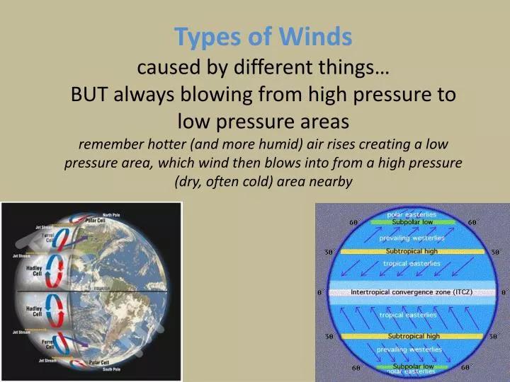
Types of Winds caused by different things… BUT always blowing from high pressure to low pressure areas remember hotter (and more humid) air rises creating a low pressure area, which wind then blows into from a high pressure (dry, often cold) area nearby. Key points to remember.

E N D
Types of Windscaused by different things… BUT always blowing from high pressure to low pressure areasremember hotter (and more humid) air rises creating a low pressure area, which wind then blows into from a high pressure (dry, often cold) area nearby
Key points to remember • Pressure (measured in Pascals or in millibars) is a measured of force per unit area…caused by gas molecules colliding with a surface • P = F/A can be units of Newtons/m2 • Winds are named by where they are blowing from • All air exerts pressure, sea levels has more pressure than in mountains for example due to more molecules colliding per unit area • Winds are created by pressure gradients and move from high to low pressure • Wind speed is increased as pressure difference increases • Hot air rises (since less dense), expands and often produces precipitation • Winds caused by unequal heating of surfaces, but can be from global pressure gradients, regional (mesoscale) ones, or localized (microscale) ones
Global Wind Patterns driven by six convection cells: Hadley Cell, Ferrel Cell and Polar Cell
InterTropical Convergence ZoneITCZ the “doldrums”
If Earth did not rotate, wind patterns would be simply N to South along the surface • Thermal convection leads to formation of convection cell in each hemisphere • Heat Energy is transported from the tropics toward poles in upper atmosphere • Cold air sinks and shuttles back toward equator along surface
Coriolis effect But the earth rotates, so there is a tendency for objects moving over long distance (like air masses) to curve due to “coriolis effect” • Curve to right in N. Hemisphere • Curve to left in S. Hemisphere • This leads to winds generally blowing in east/west directions and having spin to them
CORIOLIS EFFECT • THE ROTATION OF THE EARTH CAUSES THE AIR TO MOVE AT ANGLES FROM THE EQUATOR TO THE POLES AND BACK. • http://uwf.edu/atc/projects/coriolis/main.swf • http://www.classzone.com/books/earth_science/terc/content/visualizations/es1904/es1904page01.cfm?chapter_no=visualization
Global Scale Winds in N. Hemisphere due to Hadley, Ferrel and Polar Convection Cells • Polar Easterlies: blowing from East to West north of the 60°Latititude line • Prevailing Westerlies between 30° and 60°N latitude: dominant wind pattern blowing west to east across the US • Northeastern Tradewinds (blow from NE to West along the tropics, heavily used for trading goods with ships • Equatorial doldrums (Intertropical Convergence Zone): winds cancel out, no prevailing wind
Mesoscale (Regional) Winds • High pressure areas: downward, dry divergent air, spin in clockwise direction as leaving • Low Pressure areas: converging, rising moist air, expands, condenses and leads to precipitation; spins in counterclockwise direction as air is entering low • Wind blows from High Pressure to Low Pressure
Low pressure areas • Warm, humid air rises, expands and condenses = causing a low pres air mass at surface and condensation above (lots of rain or snow) • Global lows at Equator and polar region at 600 N and S.
High Pressure Areas • Dense, dry air (can by cold dense or hot arid) sinks due to gravity = creating high pressure at surface and outward blowing wind, very little precipitation • 30 latitude is areas of most large deserts like Sahara in Africa, Saudi Arabian deserts, Asians Desert or Death Valley USA • Global high pressure regions at 30° N and S as well as poles at 90° N and S
See coriolis effect as high pressure wind blows into a low pressure air mass • Wind blowing in curve to the right in N. hemisphere • Thus, low pressure system has air spinning counterclockwise • This pattern creates tornadoes and hurricanes as well
Localized (microscale) winds • Sea breeze and land breezes near oceans • Valley and Mountain breezes • Tornadoes • Hurricanes
A. Sea breeze (or onshore breeze) in day time when land heats faster and cool breezes blows onto land named by where it is coming from….B. Land breeze (or offshore breeze) at night time when land cools faster creating high pressure which blows out to sea • Why? The sea has a greater specific heat than land and therefore has a greater capacity for absorbing heat than the land, so the surface of the sea warms up slower than the land's surface. As temperature land rises, the air above it heats, expands and rises creating a land low pressure area. The cooler air above the sea, now with higher sea level pressure, flows towards the land into the lower pressure, creating a cooler breeze.
Valley and Mountain Breeze • Valley Breeze in day time: when valley warms and air rises up the slope, cools as it rises, meats an inversion layer of cold air up top and circles back down • Mountain Breeze at night: when all air near surface of mountain cools and sinks down the slope then converging to go back up…steeper mountains cause faster winds
Yazoo County tornado in Mississippi 2010 killed 10 people Tornadoes are a violent, counterclockwise rotating column of air which is in contact with both the surface of the earth and a cumulonimbus cloud (thunderhead cloud) • 40 to 110 mph wind and travels a few miles Hurricanes (also called cyclones or typhoons) intense low pressure systems that form near tropical doldroms, travel long distances over oceans and characterized by cyclonic rotation, very wet, warm storm systems producing a lot of rain, very high wind and thunderstorms • Big hurricanes developing sinking air in the center, the “eye of the storm” which is a calm spot • must have wind speeds over 74mph (or else called tropical storms) up to around 175mph or more 2005 Hurricane Katrina in Louisiana was costliest ($81 billion) and one of the five deadliest in US history
Monsoons – Special Regional in Asia, Australia, Africa, S. and N. Americapatterns changes seasonally, not day vs. night • Winter Monsoon: continent cools more than oceans, so dense high pressure air causing wind to blow from land to sea: typically clear dry weather in winters • Summer Monsoons: continent heats up much faster than oceans, creating low pressure and onshore winds over very large distances; this brings in a lot of moisture from the oceans causing a lot of rain and snow (especially near mountains) Equator ITCZ