Download
1 / 27
290 likes | 603 Views
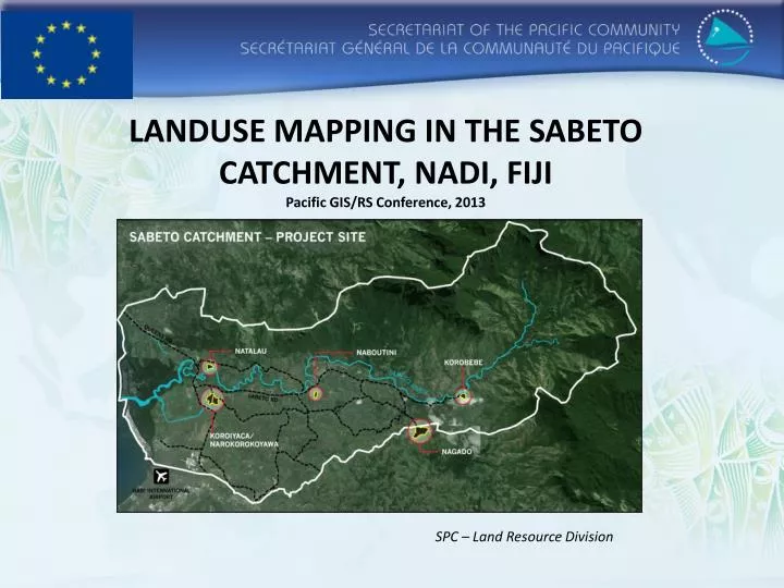
LANDUSE MAPPING IN THE SABETO CATCHMENT, NADI , FIJI Pacific GIS/RS Conference, 2013. SPC – Land Resource Division. Introduction.

E N D
LANDUSE MAPPING IN THE SABETO CATCHMENT, NADI, FIJIPacific GIS/RS Conference, 2013 SPC – Land Resource Division
Introduction • SPC, with support from USAID are assisting communities to manage their food resources and strengthen their resilience to the effects of climate variability and climate change • In partnership with MOA, SPC undertook vulnerability and adaptation assessments in the Sabeto catchment, Nadi. Assessment tools include PRAs, HIES • GIS, land use and vegetation mapping have been used to identify adaptation measures • The survey was an activity for the SPC’s Enhanced Climate Change Resilience of Food Production Systems for selected PICTs (Fiji, Kiribati, Samoa, Solomon Islands, Tonga and Vanuatu) USAID Project.
Locality Sabeto catchment covers 13819 ha and is located about 8km from Nadi town. The Sabeto road turnoff is about 5 minutes north of Nadi international Airport. The catchment is located in the Ba Province, Viti Levu and comprises of Sabeto, Nalotawa, Nadi, Vuda and Vaturu districts.
Objectives • Collect biophysical and baseline data for the catchment; • Collection and preparation of soil maps, land use capability maps and land tenure maps for the catchment. • Preparation of the current(November, 2012) land use map for the catchment after the survey.
Objective 1: Collect available Data and Baseline Map Preparations
Soils data • Obtained from the Landuse Section, Ministry of Agriculture. • Digitized soil map of Fiji. • Data includes all soil taxonomy of Fiji. (eg. Soil names, soil type and properties, etc.) • The data provided us with baseline information of the type of soils present and the production of the soil map of Sabeto catchment.
Land use Capability(LUC) • The systematic arrangement of different kinds of land according to those properties that determine its capacity for sustained production, where capability is used in the sense of suitability for productive use. Capacity depends largely on the physical qualities of the soil and the environment. • LUC for Fiji is categorized to 8 classes. • Data made available by the Landuse Section, Ministry of Agriculture
LUC Classes • Classes I to IV – Comprise of land suitable for arable cultivation. • Classes V to VII – Land not suitable for arable cultivation but suitable for pastoral or forestry use. • Class VIII – Land suitable only for protective purposes. (eg. Forest reserves, mangroves)
Cont. • The catchment has some good (39%) arable land (classes II-IV) with slope ranging from 0-15 degrees (flat- rolling slopes). • Majority of the land(56%) is land classes V – VII with slope ranging from 16-35. • Much of the land classes in the catchment relate to the physiographic characteristics and the terrain.
Sabeto Land Tenure • Taken from Cadastral data of Fiji by the Lands Department. • 96% of the catchment is native land and 4% is freehold. • Landowners’ consultation are vital before any development takes place in the area.
Fieldwork • Involved driving and walking around the area and plot the types of landuse boundaries onto the printed 1:10,000 scale Worldview2 images. • Use of GPS as well.
Some land use observed and activities of the survey
GIS Integration • Mapping software was ArcGIS9.3 • Took 2 months after the survey to complete the digitized Sabeto catchment land use shapefile. • From the data we were able to determine the common land use types and practices and the amount of area they cover within the catchment boundary.
Cont. • Upper catchment is dominated by forests and upland grasslands. • Farming(sugarcane) are done on the mid section(rolling slope lands) to the lower section(flat to gently slope areas) of the catchment. • Most flat lands are mainly used for residential, commercial and recreational purposes. • Less than 2% of the catchment is used for agriculture.
Community Based Adaptation • Vulnerabilities identified • Food insecurity and reliance on imported and less nutritional food • Limited communication and access roads • Increased incidence of disease outbreaks • Increased incidence of landslides • Increased flooding of food gardens • Reduced crop yields
Community Approach • Because of the catchment’s vulnerabilities an agroforestry demo-farm was established in the catchment. • Overlaying soils and LUC data made it easier to pre-determine the soil properties and land use capability of the demo-farm. Although soil testing was also done on sight as well as slope measurements for more accuracy. • As a result some all year round crops were selected and planted to help diversify food productions and sustainable land management was also practiced on the farm because of the sloping-terrain.
Other adaptation measures • Promotion of livestock diversity • Improve farming practices through community training on plant propagation, nursery management, climate ready crops, crops and livestock management • Improve pest and disease control • Increase community disaster preparedness
Agroforestry Model Farm, Vaturu District School, Nagado.
Acknowledgements • Ministry of Agriculture for their help in the assessment and Soils data. • SOPAC for the WorldView2 satellite images.
Vinaka Tuvuki Ketedromo tuvukik@spc.int