Download
1 / 23
240 likes | 442 Views
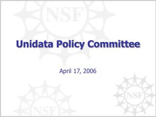
Unidata ’ s TDS Workshop TDS Overview – Part II. 22-24 October 2012. THREDDS Data Server. Servlet Container. catalog.xml. Remote Access Client. THREDDS Server. WCS. OPeNDAP. HTTPServer. WMS. NetCDF-Java Library. configCatalog.xml. IDD Data. Datasets. thredds.ucar.edu.

E N D
Unidata’s TDS WorkshopTDS Overview – Part II 22-24 October 2012
THREDDS Data Server Servlet Container catalog.xml Remote Access Client THREDDS Server • WCS • OPeNDAP • HTTPServer • WMS NetCDF-Java Library configCatalog.xml IDD Data Datasets thredds.ucar.edu
THREDDS Data Server Servlet Container catalog.xml Remote Access Client THREDDS Server • WCS • OPeNDAP • HTTPServer • WMS NetCDF-Java Library configCatalog.xml IDD Data Datasets thredds.ucar.edu
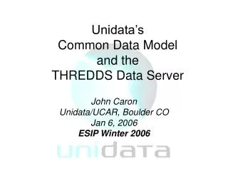
Application Scientific Feature Types Datatype Adapter NetCDF-Java/ CDM architecture NetcdfDataset CoordSystem Builder NetcdfFile THREDDS I/O service provider Catalog.xml OPeNDAP NetCDF-3 NIDS NetCDF-4 GRIB NcML HDF5 GINI Nexrad DMSP
CDM: Coordinate Systems Used to geolocate data Dataset must describe the coordinate systems used Use conventions to describe coordinate systems CF Convention (recommended) Other conventions are recognized by netCDF-Java library What you get if your data follows conventions Standard visualization, debugging, and data manipulation tools Standard servers to make your data remotely accessible
CDM: Scientific Feature Types • Gridded Data • Radial Data • Swath Data • Discrete Sampling Features • Point data • Station data • Profile data • Trajectory (e.g., aircraft track) data
CF-1.6 Discrete Geometry • Originally called Point Observation Convention • Encoding standard for netCDF classic files • Challenge: represent ragged arrays efficiently • Classifies data according to connectedness of time/space coordinates • Defines netCDF data structures that represent features • Make it easy / efficient to • Store collections of features in one file • Read a Feature from a file • Subset the collection by space and time
Feature Types • point: a single data point (having no implied coordinate relationship to other points) • timeSeries: a series of data points at the same spatial location with monotonically increasing times • trajectory: a series of data points along a path through space with monotonically increasing times • profile: an ordered set of data points along a vertical line at a fixed horizontal position and fixed time • timeSeriesProfile: a series of profile features at the same horizontal position with monotonically increasing times • trajectoryProfile: a series of profile features located at points ordered along a trajectory
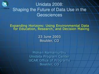
THREDDS Data Server Servlet Container catalog.xml Remote Access Client THREDDS Server • WCS • OPeNDAP • HTTPServer • WMS NetCDF-Java Library configCatalog.xml IDD Data Datasets thredds.ucar.edu
Data Access Services • Bulk File Transfer • HTTP Server (any file) • Remote access, subsetting CDM files • OPeNDAP (any* CDM file) • Web Coverage Service (grids) • Web Map Service (grids) • Others • NetCDF Subset Service (grids) • Radar Collection Subset Service • CDM Remote Service
Data Access ServicesClients • OPeNDAP • IDV, Ferret, GrADS, NCO, NCL • IDL, MatLAB • WCS • GDAL, CADCorp, George Mason, OWSLib • WMS • Browsers, Portals, ARC GIS, Google Earth OWSLib, etc • NetCDF Subset Service • HTML forms interface • Web service (CUAHSI) • ESRI ArcGIS (manual download of netCDF-CF)
OPeNDAP Service • Protocol for remote, subset access to CDM files • Current version 2.0; NASA ESE standard • Working on new 4.0 protocol spec • TDS can serve any* CDM file • Subsetting by variable, index range
OGC Web Coverage Service (WCS) • TDS supports WCS 1.0 • Can subset the dataset by: • Lat/lon or projection bounding box • time and vertical coordinate range • list of Variables • Return formats • GeoTIFF floating point, grayscale • NetCDF/CF-1.0 • No reprojections, resamplings • Restricted to Gridded Datasets the CDM recognizes • Additional WCS restriction: • Grid must be evenly spaced in x,y
OGC Web Map Service (WMS) • TDS WMS: • Supports WMS 1.3.0 and WMS 1.1.1 • Based on ncWMS (Jon Blower, Univ of Reading) • Returns map images • Can also return information about a particular map pixel (e.g., a timeseries at a given map pixel) • ncWMS notable features • Fast generation of images • Ability to read CDM datasets on variety of projections • Can reproject images into large number of coordinate systems • WMS specification supports 4D data (tools often do not)
NetCDF Subset Service • Allow to subset the dataset by: • Lat/lon bounding box • time and vertical coordinate range • list of Variables • Output: NetCDF-3 and -4 (classic), XML, CSV • Gridded Data • Output is a CF-netCDF file • Variation of WCS (simplified request protocol) • Grid as Point Datasets • Extract vertical profile, time series from one point in model data
Metadata ServicesncISO • Developed by NOAA/NGDC • Supports three metadata services • Provides an NcML representation of a dataset • Provides an ISO 19115-2 metadata representation of a dataset • Provides an evaluation of how well the metadata contained in the dataset conforms to the NetCDF Attribute Convention for Data Discovery (NACDD)
NetCDF Subset Service (NCSS) - API for subsetting datasets
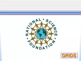
THREDDS Data Server Servlet Container catalog.xml Remote Access Client THREDDS Server • WCS • OPeNDAP • HTTPServer • WMS NetCDF-Java Library configCatalog.xml IDD Data Datasets thredds.ucar.edu
NASA World Wind Cadcorp SIS Google Earth WMS Interoperability 3rd-party clients can’t use the custom WMS extensions Godiva 2
Using WMS and NCSS * From PacIOOS site, developed by John Maurer, U of HI
Using WMS and NCSS * From PacIOOS site, developed by John Maurer, U of HI