Download
1 / 15
150 likes | 158 Views
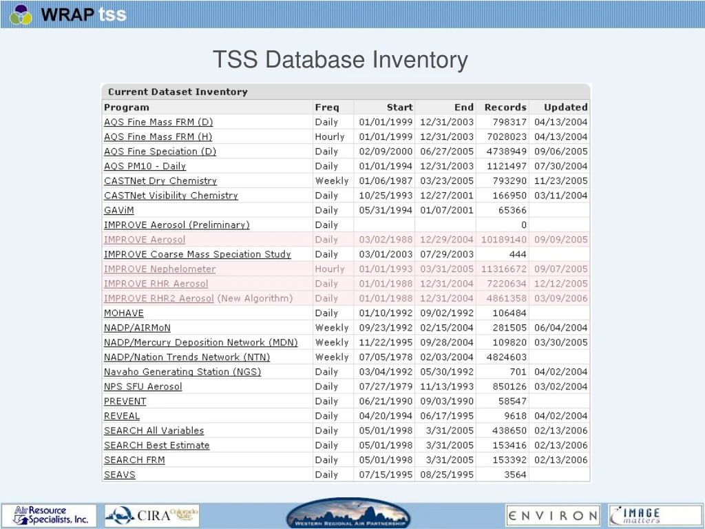
TSS Database Inventory. TSS Modeling Data Preparation. CIRA has… Received and imported the 2002 and 2018 modeling data Decided to initially store only IMPROVE site-specific data Decided upon a daily aggregation of the hourly data Considered an appropriate format for future data updates

E N D
TSS Modeling Data Preparation • CIRA has… • Received and imported the 2002 and 2018 modeling data • Decided to initially store only IMPROVE site-specific data • Decided upon a daily aggregation of the hourly data • Considered an appropriate format for future data updates • We need to… • Determine how to describe the modeling data to the user • Determine appropriate “method” descriptions for model runs • Make the data available through the various existing tools • Provide guidance to the user in making use of the raw data
TSS Emissions Data Preparation • Questions and Issues… • Which inventories are stored in the TSS? Most recent versions only? • Do we want to store emissions as model scenarios, emissions species cross-referenced to modeled/monitored IMPROVE species, and/or source categories? • How is it stored? GIS layers only or in CIRA database? • What is the spatial and temporal resolution of TSS-available data by source category/type? Do we want to qualify the interpretation of these data? • What layers have been chosen for display on the TSS? • Where do these layers exist/how are they accessed?
Major Components of the TSS • TSS website: http://vista.cira.colostate.edu/wraptss • TSS database: OLTP (metadata) and DSS (data) • TSS tools: A preview later… • Spatial data “library”: GIS layers and data • Arc/IMS website: http://maps.environdenver.com/website/WRAP_TSS/viewer.htm • Integrated Mapping Tool: http://phoenix.cira.colostate.edu:8080/smc/ • Metadata cataloging system • Documents
Major Components of the TSS • We want to consider the following questions: • Do existing and planned tools meet SIP writers’ needs? • If not, what additional functionality needs to be developed? • What are the respective priorities of data and feature requirements? • How do we define our scope and adjust it reasonably as the TSS evolves (i.e. avoid “feature creep”) • How do we incorporate user feedback in a responsive but judicious manner? • How do we play to the strengths and leverage the limitations of the TSS?
Leveraging the limitations: “Static” vs. “Dynamic” Static resources: “Hard-copy”, non-interactive products that can simply be accessed, browsed, and downloaded. The user has little or no control over manipulating the base data or formatting the output – they simply take what they are given. Dynamic resources: Interactive tools that can be used to select base data, format output, and create static products. Such tools usually consist of web forms with controls and “widgets” to enable various degrees of user interaction. More flexible and powerful than static products, dynamic tools usually require substantial time and effort to develop. What balance between static and dynamic can we find in order to get the most “bang for our buck” during the first phase?
Version Control in the TSS: Some questions… What is “version control”? A system for tracking and describing a particular edition or version of a resource. • To what TSS resources should we apply version control? • Database • Spatial data • Static products • Documents • Website • With what frequency should we archive versions of the TSS?
Version Control in the TSS: A possible solution • Archive complete versions of all major components • Perform this archival yearly -- OR -- • After significant updates to any of the components • Determine a consistent method for providing access to these archives • Determine an intuitive method for allowing the user to “tie” a set of analyses (such as a SIP) to a particular archived version of the TSS • We could even maintain a “separate” web site for each archived version of the TSS Pros: Relatively easy to implement; provides an unambiguous distinction between versions of the TSS Cons: Takes a lot of space
TSS Maintenance Activities through December 2007 • Hardware maintenance • Servers, network, disks • Software maintenance • Bug fixes, usability enhancements • Patches, hot fixes, upgrades Data and Resource Maintenance • Backups, restorations, recovery • Data updates and corrections • Content updates and corrections • User maintenance (technical support) • Online help and documentation • Phone and email support
Summary of Activities through December 2007 • Complete the integration of modeling and emissions data • Refine and extend the available repository of “static products” • Further refine the integration of GIS capabilities • Continue to refine and extend existing dynamic tools, per priorities • Develop the Excel template “tool” concept • Add a mechanism to allow users to upload data and analyses • Develop the capability to link the TSS to other existing web databases and resources • Realize a more complete implementation of metadata
GIS in the TSS • Integrated Map Tool (IMT) a.k.a the Map Widget: • A lightweight, embeddable component • Can be used to construct composite web pages • Can be “driven” by other components (responds to events) • Can “drive” other components (raises its own events) • Can be used to access arbitrary, remote GIS layers • Arc/IMS website: • A standalone application • Cannot be used to construct composite web pages • Cannot easily interact with other components • Cannot easily provide access to arbitrary, remote GIS layers • Our first line of defense for offering access to new spatial layers
Goals for continued GIS development • Continue to refine the functionality of the IMT per TSS priorities • Achieve a more complete integration of the IMT with TSS tools • Consolidate GIS access to a single “point of entry” • Refine the content, volume, and user-friendliness of spatial metadata • Optimize our choices of default layers and layer combinations (make it easy on the user – what they want is what they see first) • Minimize the amount of GIS interaction necessary to create products (make the GIS as unobtrusive but useful as possible) • Enable an “advanced” level of GIS interactivity for those users who desire it