Download
1 / 43
480 likes | 730 Views
Shoreline & Seafloor Features. Biblical Reference. When a gentle south wind began to blow, they saw their opportunity; so they weighed anchor and sailed along the shore of Crete. Acts 27:13. The Shore.

E N D
Biblical Reference When a gentle south wind began to blow, they saw their opportunity; so they weighed anchor and sailed along the shore of Crete. Acts 27:13
The Shore • Area of land between the lowest water level at low tide and highest area affected by storm waves. • Continuous, dramatic geologic activity – very impressive rock formations or wide sandy beaches. • Shorelines are shaped by waves, tides and currents.
Beaches • A beach is an area where sediment is deposited along the shore. • The size of sediments depends up on the energy of the waves. • Large waves create pebbles or cobbles. • Smaller waves create fine sand.
Forces on a Shoreline • Wave Impact • The impact of large, high-energy waves against the shore is awesome yet violent. Each breaking wave may hurl thousands of tons of water against the land, sometimes causing the ground to tremble. • Abrasion • Abrasion is the grinding action of rock fragments in the water.
Forces on a Shoreline • Wave Refraction • Waves move faster in deep than shallow water. • The difference causes a wave to bend (or refract). • Headlands receive most of a wave’s energy, while the remaining energy is spread out along the shoreline of a bay.
Forces on a Shoreline • Longshore Transport • A longshore current is a near-shore current that flows parallel to the shore. • Turbulence allows longshore currents to easily move fine suspended sand and to roll larger sand and gravel particles along the bottom.
Wave-Cut Cliffs & Platforms • Wave-cut cliffs result from the cutting action of the surf against the base of coastal land. • A flat , bench-like, wave-cut platform forms in front of the wave-cut cliff.
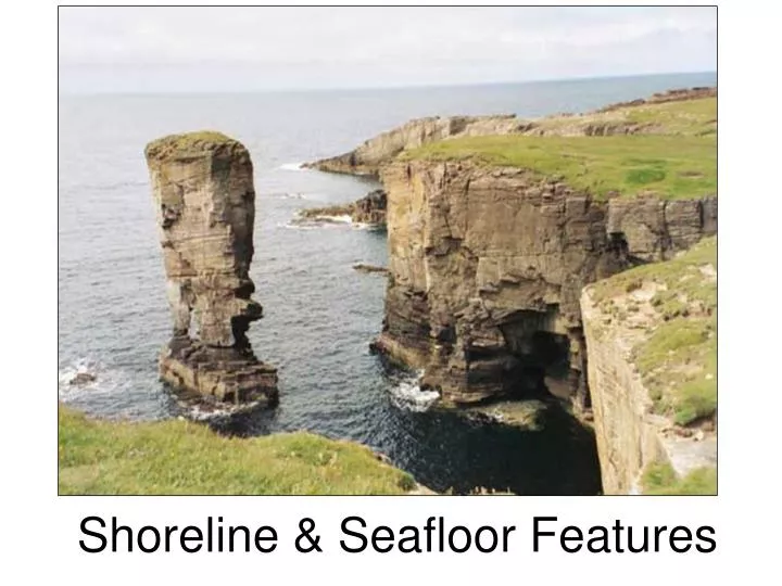
Sea Arches and Stacks • When two caves on opposite sides of a headland unite, a sea arch results. • Eventually, the arch falls in, leaving an isolated remnant, or sea stack, on the wave-cut platform.
Longshore Bars • Longshore bars are sandbars that form in front of most beaches. • Waves break on the longshore bar in an area called the Surf Zone. • The deeper water between the shore and the longshore bar is called the longshore trough. • Waves also produce rip currents, which flow through gaps in longshore bars. • Rip currents can reach up to 8 km/hr (5 mph).
Spits& Tombolos • A narrow bank of sand, projecting into the water from a bend in the coastline is called a Spit. • A tombolo is a ridge of sand that forms between the mainland and an island, changing the island into a peninsula. Spit Tombolo
Baymouth Bars & Barrier Islands • Baymouth bars form when spits close off bays. • Long ridges of sand deposited off mainlands by longshore currents are called barrier islands. • Barrier islands can be several km wide and long. • There is a continuous chain of barrier islands along the Gulf Coast and off the coast of New England.
Baymouth Bars & Barrier Islands Baymouth Bar Barrier Island
Lagoons • Protected bodies of water behind baymount bars and barrier islands are called lagoons.
Shoreline Formations are caused by: • Erosion • Wave-Cut Platforms and Cliffs • Sea Arches and Stacks • Longshore Currents • Longshore Bars • Deposition • Barrier Islands - Lagoons • Spits - Baymouth Bars • Tombolos
Human Effects • Over half the population in the nation lives in a coastal area. • Coastal environmental changes: • Pollution • Shoreline Erosion • Wetland and Wildlife Habitat Loss
Protective Structures • Protective structures are built to prevent beach erosion. • Seawalls are built parallel to shore to prevent beachfront property from powerful storm waves. • Seawalls can increase beach erosion by re-directing wave energy back toward the beach.
Groins & Jetties • Groins are wall-like structures built perpendicular to the shoreline to trap sand. • Groins interrupt longshore flow, robbing beaches down from the groins of sand deposits. • Jetties, walls of concrete built to protect harbor entrances, also cause downstream beach erosion.
Groins & Jetties Groins Jetty
Breakwaters • Breakwaters, built parallel to the shoreline, provide anchorages for small boats. • Sediments are often deposited behind the breakwater.
Changes in Sea Level • In the last 100 years, global sea level has risen 10 – 15 cm, and is rising approximately 3 mm/yr. • Effects: • Fjords are deep coastal valley that were scooped out by glaciers and filled when sea level rose. • If all polar ice sheets melted, sea level would rise 70 m, completely flooding entire countries and most coastal areas of the United States.
Pop Quiz Identify whether the following statements are true or false. ______ The location of the shoreline changes as the tide moves in and out. ______ Rip currents can only get as fast as 2 mph. ______ Groins and jetties are built parallel to the shore. ______ If all of the global ice sheets melted, sea level would rise 70 m. true false false true
Pop Quiz Which coastal landform is not produced by longshore currents? Barrier Island Sea Stack Sand Spit Baymouth Bar
Pop Quiz Which feature is not caused by erosion? Wave-Cut Platforms Wave-Cut Cliffs Sea Stacks Original Headlands
The Seafloor • Features similar to Land: • Plains • Plateaus • Canyons • Mountains • Continental Margin: Part of an ocean next to a continent. • Extends from shoreline to deep ocean
Parts of the Continental Margin Continental Shelf: Shallow part of a continent closest to shore Continental Slope: Extends from Continental Shelf to Deep Ocean Continental Rise: At the base of the slope where sediments collect.
Ocean Basins • Seafloor is shaped like a Basin. • Ocean Basin Features: • Continental Shelves • Continental Slopes • Continental Rises • Abyssal Plains • Mid-Ocean Ridges • Seamounts • Trenches
Ocean Basin Features Abyssal Plains: large flat plains of the seafloor that extend across the ocean basin. Mid-Ocean Ridges: Where tectonic plates pull apart to form volcanic mountains Seamounts: Mountains rising from the seafloor that don’t reach the surface Ocean Trenches: Tectonic plates collide with ocean plates to form deep canyons.
Abyssal Plains • Thick layers of sediment cover Abyssal Plains • In some areas, underwater volcanoes form islands.
Mid-Ocean Ridges • Continuous mountain ranges that extend along Ocean Basins. • Earth’s tallest and longest mountain range • More than 65,000 km in length • As the plates move apart, lava from volcanoes forms new seafloor. The Ocean Floor
Deep-sea Trenches • Deep-Sea Trenches are elongated (or arc-shaped) depressions in the sea floor. • Deep-Sea Trenches are narrow (~ 100 km wide) but can be thousands of km long. • The Peru-Chile Trench is almost 6,000 km long, but has an average width of 40 km. • Most Deep-Sea Trenches are next to chains of volcanic islands.
Hydrothermal Vents • A hydrothermal vent is a hole in the ocean floor that allows hot magma to flow. • Most are located along the bottom of rifts in mid-ocean ridges. • Black Smokers are the result of metal oxides and sulfides. • Temperatures can exceed 350 C. • White Smokers eject warm water.
Seamounts & Guyots • There are two volcano types on the seafloor. • Seamounts are solitary submerged basaltic volcanoes that are greater than 1 km in height. • When a seamount becomes extinct, and the top erodes, it becomes a Guyot.
Marine Sediments • Ocean-floor sediments can be classified according to their origin into three broad categories: • TerrigenousSediment (land) • Biogenous Sediment (life) • Hydrogenous Sediment (water) • Terrigenous sediments consist primarily of mineral grains that were eroded from continental rocks and transported to the ocean. • Most common: Deep-Sea Mud, which is a reddish color due to iron content.
Marine Sediments • Biogenoussedimentsconsist of shells and skeletons of marine animals and algae. • Calcareous ooze is thick biogenoussediment produced by dissolving calcium carbonate shells. • Siliceous ooze is biogenous sediment made of silica-based shells of single-celled animals & algae. • Hydrogenous sediment consists of minerals that crystallize directly from ocean water through various chemical reactions.
Pop Quiz Match the following terms with their definitions. ___ abyssal plain ___ guyot ___ seamount ___ deep-sea trench ___ mid-ocean ridge A.Elongated depression in the seafloor extending thousands of miles B.large, extinct basaltic volcano with flat, submerged top C.Basaltic submerged volcano on the seafloor D.smooth, flat part of ocean floor E.Chain of underwater mountains with active and extinct volcanoes D B C A E
Pop Quiz What do the sediments of the abyssal plain mostly consist of? Sand and Gravel Salt Seashells Mud and Oozes
Pop Quiz Which Seafloor feature can be found along rifts in mid-ocean ridges? Deep-Sea Trenches Seamounts Hydrothermal Vents Guyots