Download
1 / 30
320 likes | 473 Views
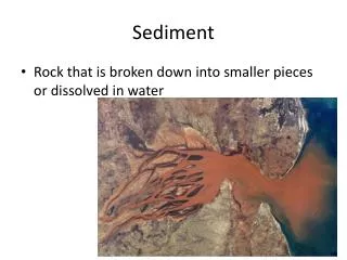
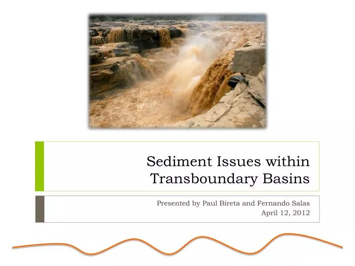
Sediment Issues within Transboundary Basins. Presented by Paul Bireta and Fernando Salas April 12, 2012. What is sediment?. Solid particles, minerals and/or organic material transported by water. Controlled by transport capacity of flow and supply of sediment.

E N D
Sediment Issues within Transboundary Basins Presented by Paul Bireta and Fernando Salas April 12, 2012
What is sediment? • Solid particles, minerals and/or organic material transported by water. • Controlled by transport capacity of flow and supply of sediment. • Suspended sediment load, wash load, and bed load. • Channel systems, flood plains, wetlands and estuaries. • Balanced by erosion and deposition • Development and extreme climate events disturb the equilibrium
The sediment conundrum… • Floods deposit nutrients within flood plains. • Dams mitigate flood damage. • Increased sediment deposition can increase flooding.
Sediment is a complex problem… • Management Issues in Large River Basins • Flooding • Agriculture • Erosion • Reservoir sedimentation • Aquatic life and biodiversity • Population growth (i.e. land use and water use) • 50% of major rivers show statistically significant upward or downward trend in sediment loads • Climate Change – wetter climates leads to increased erosion and runoff
Upstream Effects • Hydropower • Adequate flows for power generation. • Degradation of rotors. • Reservoir Capacity • Decreasing • Floods
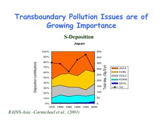
Sedimentation in Reservoirs Meganiño 1983 Meganiño 1998 1976 1976
Downstream Effects • Erosion • Bridges • Wetlands and estuaries • Support biological diversity – fish breeding (nutrients) • Nutrient loads on floodplains • Agriculture now uses fertilizer that can be harmful
Sediment Accumulation • Flooding – backwater lakes in Mississippi have lost 30-100% of capacity • Navigation • Dredging costs are high • Infrastructure • Irrigation pump intakes and canals • Domestic water supplies – water treatment and distribution • Nile River – floods can generate up to 23,000 ppm disrupting treatment; only 50% of the population has access to safe drinking water • Sediment contamination
Global perspective • Estimated 800,000 dams in the world today. • 1/4th of sediment flux trapped. • China – 22,000 vs. United States – 6,500
HiSTORical Perspective • ~ 5,000 dams built by 1950 • ~ 45,000 dams built by 2000 (2 large dams per day)
Large dependence on hydropower • 70% of economically feasible hydropower potential in developing countries • 93% potential in Africa • Since 2003, the World Bank has financed 67 large hydropower projects • ~ $3.7 billion
Development in Transboundary Basins • Involve multiple stakeholders • Agriculture • Mines and Industry • Communities in flood-prone areas • Reservoir managers • Wetland and environmental organizations • Recreational users • Focus on water quantity…not quality as much. • Mekong River basin currently has 134 dams either planned or operating (China, Myanmar, Thailand, Laos, Cambodia and Vietnam)
Regional specific solutions • Climate (i.e. stationarity is dead) • Tectonics and geology • Topography • Soils • Regional differences and within watershed differences • Hydrology • Vegetation and land use • River control structures • Soil and water conservation measures • Tree cover • Land use disturbances (e.g. agriculture, mining etc.)
Modeling Sediment Load and Transport • Universal Soil Loss Equation • Physical models • Stochastic analysis of loading
Yellow River • Highest sediment yield of any river in the world • 16.3 billion tonnes (1919 – 1960) • 0.84 billion tonnes (1952 – 2000) • 1,130.3 tonnes per km2 • Average annual runoff - 47.38 billion m3 • Low flow to oceans and reservoirs • Loess plateau highly erodible • Most the erosion comes from a relatively small area (110,000 km2) • Conservation Measures
Yellow River • Highest sediment yield of any river in the world • 16.3 billion tonnes (1919 – 1960) • 0.84 billion tonnes (1952 – 2000) • 1,130.3 tonnes per km2 • Average annual runoff - 47.38 billion m3 • Dykes and Levees built to control flooding • Bed of river now 5 m above surrounding area
Yellow River Upstream Issues • Loess plateau highly erodible • Most the erosion comes from a relatively small area (110,000 km2) • Increased flooding Downstream issues • Low flow to oceans and reservoirs • In 1997, no flow reached ocean for 226 days
Yellow River Measures Taken • Sluice gates opened at dams to release trapped sediment • Decreases hydropower generation • Conversion of upstream land • Cropland to Grazing • Reforestation • Terracing • 1976 - Artificial channel constructed to discharge sediment into Bohai Sea • Creates 25-50 km2 of new land per year
Mississippi River • Drains 1,245,000 sq miles • River course changes every ~1000 years • Results in sediment being deposited in different areas • Pre 1900, river moved an average of 400 million tons of sediment • Last 20 years, only 145 million tons • 20.5-53.3 mm/yr lost, averaged over entire watershed
Mississippi River Causes • Levees built to protect flooding and for navigation • Plan was to control channel and reduce dredging • Led to increased sedimentation, which increased flooding and dredging • Increase in agriculture • Clearing of deep-rooted vegetation • Tilling of soil and planting • Irrigation
Mississippi River Effects • Mississippi delta losing wetlands • 16.57 sq miles per year • Wetland loss also due to large storm events, but significantly higher than previously measured • Increased flooding • River channel now not able to flow naturally • Lakes are filling with sediment and are not able to dampen flooding effects
Mississippi River Possible Solution • Researchers at UT have been working to model possible solutions • Plans to cut through two major levees downstream of New Orleans to release sediment • Release would balance out lost sediment and reestablish positive land flux
Rhine River • Major pollution in the past • Contaminants accumulate in sediment • Natural sedimentation processes tend to bury these sediments • Decrease in sedimentation due to upstream development • Contaminated sediments are being exposed by both natural suspension and dredging • Rhine River is a major drinking water source
Conclusions • River control devices are increasing sedimentation in river systems • Agricultural practices are increasing the amount of erosion into these river systems • Sediment dynamics need to be taken into account for future project, both economically and environmentally
Questions • Should countries be investing in dams and reservoirs when we know of the negative environmental impacts? Who should be responsible for assisting countries with sediment modeling before projects are undertaken? • How do we balance urbanization and development with environmental sustainability? Are river control systems sustainable? • Will these systems reach a new steady-state with the river control systems or will these problems continue to compound?