Download
1 / 16
160 likes | 298 Views
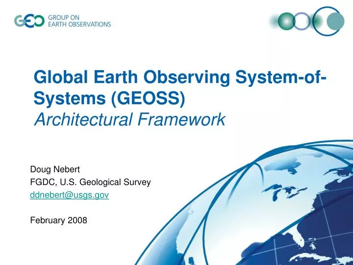
Global Earth Observing System-of-Systems (GEOSS) Architectural Framework. Doug Nebert FGDC, U.S. Geological Survey ddnebert@usgs.gov February 2008. Intergovernmental Group on Earth Observations (GEO). 72 Member countries plus the European Commission 52 Participating Organizations

E N D
Global Earth Observing System-of-Systems (GEOSS)Architectural Framework Doug Nebert FGDC, U.S. Geological Survey ddnebert@usgs.gov February 2008
Intergovernmental Group on Earth Observations (GEO) • 72 Member countries plus the European Commission • 52 Participating Organizations • GEO Secretariat (Geneva) • Committees: • Architecture and Data • Capacity Building • Science and Technology • User Interface
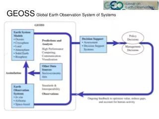
What is GEOSS?Global Earth Observing System of Systems • GEOSS is a distributed system of systems built on current international cooperation among existing Earth observing and data management systems – in situ and remote sensors and systems • GEOSS enables the collection and distribution of accurate, reliable Earth Observation data, information, products, and services in an end-to-end process • GEOSS recognizes and promotes the deployment of geospatial standards to enable broad access and interoperability among diverse systems – engages thespace and environment communityto adopt and expand Spatial Data Infrastructures
GEOSS infrastructure elements • Components • Systems, projects, programs, initiatives • Services • Web services, brokered services, linked with information content for delivery • Registries • “Yellow-pages” directories of common GEOSS resources • Clearinghouse • Cross-GEOSS search capability for services and data • Web Portals • User interface to access all GEO resources, search GEOSS Registries and Clearinghouse
GEOSS Registries as common infrastructure • GEOSS Components Registry • Systems, initiatives, programs and their operators • GEOSS Services Registry • Web service interfaces and websites with links to all relevant associated standards or practices • GEOSS Standards and Interoperability Registry • Service interface standards, data formats, schemas, and other standards • Non-standard community practices can be registered as “special arrangements” • Best Practices Registry/Wiki – under development • Earth Observation (User) Requirements Registry – under development
GEOSS registry system objectives • To register components and have them approved by the GEO Secretariat, • To register services and associate them with GEOSS-recognized standards – and special arrangements for implementations using non-recognized approaches, • To register special arrangements and GEOSS-recognized standards. • Taxonomy of standards types is used to assist in the discovery and classification of GEOSS service implementations. • Best practices (wiki) and EO User Requirements • On-line access • http://geossregistries.info/ • http://seabass.ieee.org/groups/geoss/
Catalogues GEOSS workflow accesses Community Resources 6 Web Portal User 5 accesses searches searches 7 get catalogue services GEOSS Clearinghouse invokes GEOSS Component, Service registry 8 references 3 accesses 4 2 Standards, Special Arrangements Registries contribute Offerors 1 Service(s) Component System
GEOSS Registries The Registries store organizational, system, and service information in the context of existing standards and practices within the GEO community.
Registering items • GEO members and participating organizations are invited to register their offers for GEOSS participants to find • Components and Service Registry created and hosted at George Mason University • Registered services include data access services, WMS, metadata catalogs, order, data transformation, etc. • Services should be standards-based but may alternately reference community practices or ad hoc standards, known as “special arrangements” • Standards registry hosted by IEEE to provide official list of registered standards and special arrangements
Registration Process Enter Individual Info Link to SBAs Enter Component Info Link to Standards GEO Affiliation Enter Service Info Data format, metadata, Protocol, schema, Service specification Done http://geossregistries.info
GEOSS Clearinghouse • Clearinghouse is a broker to Community Catalogues • Searches GEOSS Service Registry to identify services that can be searched • Community Catalogues may either be “harvested” in advance or “searched” at the time of a user query • Searches received from GEO Web Portal, Community Portals or any other external application acting as a catalog client • Brief or full responses are marshaled and returned to requesting client as XML
6 Collate response GEOSS Clearinghouse Web Portal, Client, DS Client, Desktop application 7 4 OGC CSW 2.0.2 2 Register catalogs as services 3 5 1
Other Services Processing Services Workflow Management Portrayal Services Community Catalogues Community Portals CSW/SRU/UDDI CSW/ISO23950 Get list CSW/ISO23950 Register GEOSS Architecture – Engineering Viewpoint Client Tier GEOSS Web Portal GEO Web Site Decision-Support Applications Business Process Tier GEOSS Registries GEOSS Clearinghouse Components Services Standards Requirements Access Tier Data Access Services Sensor Access Services Model Access Services Direct Broadcast Other Services
Initial Operating Capability • An Initial Operating Capability (IOC) was established for GEOSS in November 2007 largely as a result of a GEOSS Architecture Implementation Pilot, Phase 1. Several demonstrations portray the IOC functionality. • Users can access the GEOSS IOC functionality through the GEOSS Web Portal Candidates, Community Portals and Decision Support Clients. • Providers can register their services as part of the IOC at the GEOSS registry system. • Developers can view a description of the GEOSS IOC architecture through the website: http://www.ogcnetwork.net/GEOSS_IOC
Services Catalogues Catalogues GEOSS Common Infrastructure User GEO Web Site accesses links links GEO Portal GEONETCast GEOSS Common Infrastructure searches GEOSS Component Registry Service Registry Catalog Query Clients accesses GEOSS Clearinghouse references GEOSS Standards and Special Arrangements Registry Links to Other Community Resources Accesses all Registered Community Resources Register Registered components External resources Documents Websites/ Webportals Websites/ Webportals RSS
For more information, contact: Douglas Nebert U.S. Federal Geographic Data Committee ddnebert@usgs.gov +1 703 648 4151