Download

1 / 24
240 likes | 318 Views
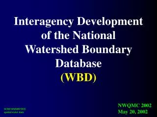
Maine Watershed Boundary Dataset. Coastal Delineations International Border Harmonization. Quebec, CA. New Brunswick, CA. New Hampshire. Atlantic Ocean. 01050002 – Coastal Washington & Hancock Counties, Maine. 1 st Iteration (early to mid-90s) of WBD stopped at land’s edge,

E N D
MaineWatershed BoundaryDataset Coastal Delineations International Border Harmonization
Quebec, CA New Brunswick, CA New Hampshire Atlantic Ocean
01050002 – Coastal Washington & Hancock Counties, Maine • 1st Iteration (early to mid-90s) of WBD stopped at land’s edge, • Islands > 10,000 acres coded • Marine waters and small islands ignored
Ragged Coastline = • Edge • Habitat Diversity • Terrestrial • Fresh Aquatic • Ocean Aquatic • Intertidal
Habitat Diversity • Shellfish beds • ESA-listed animals
Habitat Diversity • Shellfish beds • ESA-listed animals • Bald Eagle nests
Habitat Diversity • Shellfish beds • ESA-listed animals • Bald Eagle nests • Deer Wintering Areas
Habitat Diversity • Shellfish beds • ESA-listed animals • Bald Eagle nests • Deer Wintering Areas • Tidal Waterfowl
Habitat Diversity • Shellfish beds • ESA-listed animals • Bald Eagle nests • Deer Wintering Areas • Tidal Waterfowl • Shorebirds, SNI
Habitat Diversity • Shellfish beds • ESA-listed animals • Bald Eagle nests • Deer Wintering Areas • Tidal Waterfowl • Shorebirds, SNI • Shellfish, Eelgrass Beds
Blue Hill-Mt. Desert Frontal Drainages Frenchman’s Bay
Shortnosed Sturgeon • NOAA Coastal Fisheries • ESA-listed Atlantic Salmon Rivers • US Fish & Wildlife Service • Atlantic Salmon Commission
Conservation Partners that the WBD Brings to the Table • Maine Dept. of Environmental Protection • Water Quality regulation • 305b/303d reporting • Maine Dept. of Marine Resources • Shellfish Bed monitoring and closures • Maine Inland Fisheries & Wildlife • Maine Natural Areas Programs • Maine State Planning Office • NOAA Coastal Fisheries • US Fish & Wildlife Service
MaineWatershed BoundaryDataset International Border Harmonization
WBD • 5 St. John River Sub-basins form the roof of Maine • Eastern edge incomplete, doesn’t meet standard • NHD • Incomplete, stops at Canadian border Quebec New Brunswick
Similar problem on the Canadian side
International Joint Commission The IJC prevents and resolves disputes between the USA and Canada under the 1909 Boundary Waters Treaty and pursues the common good of both countries as an independent and objective advisor to the two governments. • Transboundary Hydrographic Dataset Harmonization Task Force (THDHTF) • Mike Laitta, of USGS fame, facilitating communication between US and Canada WBD/NHD counterparts. • WebEx • Face-to-face meeting 4/9/2009 between New Brunswick and Maine re: HUC8-CAN4 polygons.
01050004 01050001 Passamaquoddy Bay- Bay of Fundy St. Croix River 01050002
The Devil’s in the details. The Prestile/Meduxnekeag Sub-basin has 2 pourpoints. Two small, previously undefined drainage areas we know drain to the St. John.
Upper St. John will be split into 4 sub-basins along HUC10 boundaries. The St. John Basin will have 15 sub-basins. New polygons will be the templates for completing the NHD/NHN harmonization.