Download
1 / 8
80 likes | 190 Views
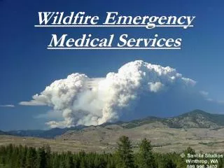
GIS Needs in Wildfire Emergency Operations . Loren Pfau PSU GEOG 588 15 December 2010. Overview . Introduction Background Research Data Needs of Selected Parties Recommendations. Background. Wildfires are major annual events in the US National Interagency Fire Center Statistics

E N D
GIS Needs in Wildfire Emergency Operations Loren Pfau PSU GEOG 588 15 December 2010
Overview • Introduction • Background • Research • Data Needs of Selected Parties • Recommendations
Background • Wildfires are major annual events in the US • National Interagency Fire Center Statistics • 10-year Average of 72,775 fires impacting 6.39 Milling acres • 2010 through 26 November experienced 66,315 fires impacting 6.39 Million acres • The FourmileCanyon fire that occurred west of Boulder, CO in September 2010 destroyed 169 homes and caused an estimated $217 Million in damages • Wildfires are challenging emergency operations • Difficult to predict • Fast-moving, long-lasting • Span multiple jurisdictions and agencies • Potential for significant risks to lives and property
Research Findings • Current use of GIS in wildfire operations are highly traditional in nature • Top-down, command & control model • National Wildfire Coordinating Group Standard: “GIS Standard Operating Procedures on Incidents” • Challenge: current layers needed for situational awareness • Social media sources are becoming significant • SDSU research • But there are limitations • The challenge, and opportunity, is to bridge the two
Citizen Mashup- Fourmile Canyon Fire Ramsay, Adam. “Social Media Helps with the Boulder Fire.” 9 September 2010. Retrieved on 12 December 2010 from: http://www.examiner.com/online-media-in-denver/social-media-helps-with-the-boulder-fire
Data Needs of Selected Parties • Emergency Management • NIMS / ICS • Field Crews • Law Enforcement • General Public • Media
Recommendations • New generations of GIS for wildfire management need to take into account social media applications • Both for making information available to the public and as a means of acquiring information from the public • Systems design needs to • Take into account nontraditional users • Plan for flexibility • During wildfire emergencies devote resources to non-traditional GIS tasks such as identifying and monitoring social media sites and traditional media outlets