Download
1 / 37
370 likes | 446 Views
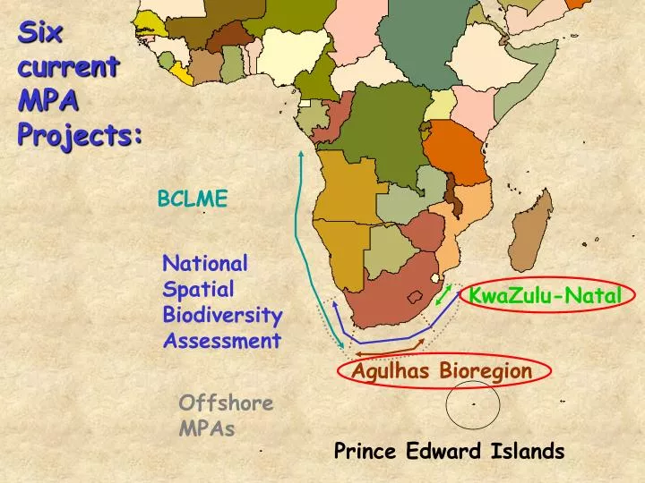
BCLME. KwaZulu-Natal. Agulhas Bioregion. Offshore MPAs. Prince Edward Islands. Six current MPA Projects:. National Spatial Biodiversity Assessment. Bioregions. (Namib Bioregion). Delagoa Bioregion. Sea-PLAN. Namaqua Bioregion. Natal Bioregion. South-western Cape Bioregion. 30 m.

E N D
BCLME KwaZulu-Natal Agulhas Bioregion Offshore MPAs Prince Edward Islands Six current MPA Projects: National Spatial Biodiversity Assessment
Bioregions (Namib Bioregion) Delagoa Bioregion Sea-PLAN Namaqua Bioregion Natal Bioregion South-western Cape Bioregion 30 m Agulhas Bioregion Dr Jean Harris KZN-Wildife 150 m KwaZulu-Natal
FINE-SCALE (high resolution/detail) Suitable for local scale management interventions PLANNING AREA Provincial waters out to the EEZ (200 nm)
1. PATTERNS • Shoreline • Habitats • Species • Offshore • Bathymetry • Reefs • Geology • Canyons • 2. PROCESSES • Oceanography • Fish spawning areas • Fish nursery areas • Fish migrations • Predictable aggregations • Dispersal routes • 3. THREATS • (lots)
1. PATTERNS CLASSIFICATION OF MARINE BIODIVERSITY
SHORELINE BIODIVERSITY MAPPING Mapping the shoreline at 100m intervals
Beach Type: Refl Deans: 1.067 Avg Grain Size: 425 µm Wave Height: 0.9m Wave Freq: 4 min-1 Slope: 1/12 B R X F S SANDY SHORES (Ronel Nel) Three major beach types were identified and mapped: 1. Reflective beaches 2. Intermediate beaches 3. Dissipative beaches 314 transects
SPECIES Seaweeds Other invertebrates • Fish • Birds Sponges
Species being mapped spatially (Kerry Sink) • Fisheries importance • 2. Over exploited species • 3. Threatened species • IUCN 2006 Red list • South African Mammal Red data book • National Spatial Biodiversity Assessment • Priority linefish species for conservation • CITES Listed • 4. Endemic species • 5. Rare species • 6. Other species of concern (NGOs, User Groups, Literature)
1. PATTERNS • Shoreline • Habitats • Species • Offshore • Bathymetry • Reefs • Geology • Canyons • 2. PROCESSES • Oceanography • Fish spawning areas • Fish nursery areas • Fish migrations • Predictable aggregations • Dispersal routes • 3. THREATS
OFFSHORE BATHYMETRY - DEPTH Council for Marine Geoscience
Reefs – Photic BioZones Shallow Reefs 2-10m (Sean Porter) Deep reefs >40m Kerry Sink 10-30 m (Cloverley Lawrence)
OFFSHORE HABITAT MAPPING Canyons Seafloor Geology
OFFSHORE HABITAT MAPPING
1. PATTERNS • Shoreline • Habitats • Species • Offshore • Bathymetry • Reefs • Geology • Canyons • 2. PROCESSES • Oceanography • Fish spawning areas • Fish nursery areas • Fish migrations • Predictable aggregations • Dispersal routes • 3. THREATS
2. PROCESSES Oceanography Offshore “Domains” – 1km x 1km Defined by ……. • * Depth • * Turbidity • * Temperature • * Chlorophyll • * Sediment type
Sea surface temperature Chlorophyll
Turbidity Data Analysis based on colour • 5 categories
Oceanographic Provinces Bakun (Ocean triads)
3. Threats & degree of impact/transformation • Commercial exploitation • Subsistence and small scale commercial use • Recreational fishing • Shark control installations • Aquarium trade – commercial • Aquarium trade - recreational • Ornamental shell trade • Mariculture • Alien invasive species • Mining • Shipping • Pollution • Non-extractive recreational activities • Coastal development and access • Natural threats e.g. cyclones • Disease • Climate change
Issues & challenges? * Offshore profiles as proxy for biodiversity - test * Integrating estuaries * Measuring threat intensity * Threats vs vulnerability * Setting targets * Connectivity & proximity factors
Bioregions (Namib Bioregion) Delagoa Bioregion Namaqua Bioregion Natal Bioregion South-western Cape Bioregion 30 m Agulhas Bioregion 150 m
FINE to MEDIUM-SCALE Suitable for bioregional prioritisation PLANNING AREA Bioregional waters out to 30 m depth
Used MARXAN to site new MPAs using coastline accessibility (by foot or boats) as a cost factor
Costs • Foot access • Boat access Features • Intertidal habitats (1:5000) • Reef fish abundance (1 km coastal segments) • Coastal dune systems (exact locations) • Marine geology (surrogate for different reef types, 1:2million) • Conservation planning analyses • MARXAN (1 km coastal planning units) • Meet targets • Avoid areas of high cost • Cluster solutions
Feature 3: Proposed coastal dune reserves (exact locations, Tinley 1985)
Costs Accessibility model
Priority areas avoided coastlines with high cost (accessibility)