Download
1 / 22
230 likes | 366 Views
The U.S. Integrated Ocean Observing System IOOS. Outline. What is the Global Ocean Observing System? What is the Ocean.US Enterprise? What is the U.S. Integrated Ocean Observing System (IOOS)? What is the status of the IOOS?. The Global Ocean Observing System.

E N D
Outline • What is the Global Ocean Observing System? • What is the Ocean.US Enterprise? • What is the U.S. Integrated Ocean Observing System (IOOS)? • What is the status of the IOOS?
Global Ocean Observing System(GOOS) • GOOS is being coordinated by U.N. agencies with the participation of some 100 ocean nations. • GOOS is an end-to-end system of observations, data management, and production and delivery of products/services. • GOOS, along with the World Weather Watch, Global Atmospheric Watch, Global Climate Observing System and Global Terrestrial Observing System, is a an element of the Global Earth Observing System of Systems
The GOOS Modules The Global Ocean Observing System (GOOS) is being designed and implemented in two modules: • A global module designed to monitor, predict, and understand marine surface conditions and climate variability; and • A coastal module designed to sustain healthy marine ecosystems, ensure human health, promote safe and efficient marine transportation, enhance national security, and predict and mitigate against coastal hazards.
Commission on Ocean Policy • Implement an Integrated Ocean Observing System • Implement ecosystem–based management • Strengthen regional approach
Ten–Year Strategic Plan for the NOPP • Achieve & sustain an Integrated Ocean Observing System (IOOS) • Promote lifelong ocean education • Modernize ocean infrastructure & enhance technology development • Foster interagency partnerships to increase & apply scientific knowledge
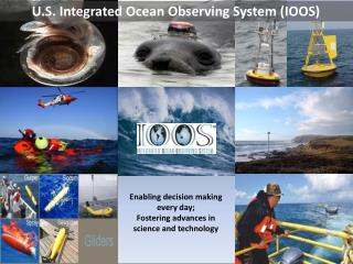
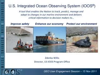
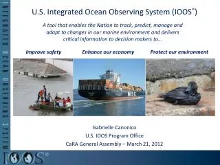
At the request of the U.S. Congress, the federal agencies of the NOPP are planning and developing a U.S. Integrated Ocean Observing System focused on: • Detecting and Forecasting Oceanic Components of Climate Variability • Facilitating Safe and Efficient Marine Operations • Ensuring National Security • Managing Marine Resources • Preserving and Restoring Healthy Marine Ecosystems • Mitigating Natural Hazards • Ensuring Public Health
The National Office for Integrated and Sustained Ocean Observing and Predictionhtttp://www.ocean.us Dr. Jack Kaye Chair, Executive Committee Thomas Malone Director, Ocean.US Office
U.S. IOOSTwo Interdependent Components Global Ocean Climate Component GOOS/GCOS Coastal Ocean Component GLs GoA NE NW MAB Regional Observing Systems SE H Isl C Cal Go Mex S Cal Carrib National Backbone Low Resolution High
Coastal Component National Backbone • Operated by Federal • Agencies • EEZ & Great Lakes • Core variables required • by regions & Federal Agencies • Networks of sentinel & • reference stations • Standards/Protocols Regional COOSs • Operated by Regional • Associations • Involve private & public • sectors • Inform Federal Agencies • of user needs • Enhance the backbone • based on user needs • Incorporate Sub–regional • systems
1st Annual IOOS Development Plan • Part I – Structure and Governance • Vision & IOOS design principles • Planning Implementing Bodies & Process • Part II – Fiscal Years 2005-2006 – Integrating Existing Assets • Integrate existing observing subsystem assets across agencies • Data management & communications • Coordinated regional development • Part III – Improving the IOOS Through Enhancements and Research • Enhance the initial IOOS • R&D priorities
Functions of Ocean.US Plan & Coordinate • Develop & maintain strategic plan • Ensure incorporation of elements into an integrated system • Recommend enhancements • Recommend R&D priorities • Promote collaboration among participating NOPP Agencies & Regional Associations
Physical Sea surface winds Sea surface waves Sea surface currents Sea level Stream flows Temperature, Salinity High Res Bathymetry Ice distribution Multidisciplinary Optical properties Bottom character/Benthic habitats Chemical Dissolved inorganic nutrient Contaminants Dissolved oxygen Biological Fish species, abundance Zooplankton species, abundance Phytoplankton species, biomass (ocean color) Pathogens Part IINational Backbone Core Variables
Part II: The Initial IOOSFY 05 – 06 Highest Priorities • DMAC (Data Management and Communications) • Establish RAs & the NFRA • Coordinated Development of Global & Coastal
Part II – Coastal ComponentThe Initial IOOS • Extend the global ocean component to the shoreline with higher resolution for • improved regional weather & climate predictions, • more efficient and safer marine operations in coastal waters, • more accurate forecasts of natural hazards & their effects, & • improved homeland security. • Develop an integrated approach to water quality monitoring & living resource assessments through more timely provision of • Surface & interior fields • nutrients & dissolved oxygen • phytoplankton biomass (Chl) & macrozooplankton abundance • Extent and condition of benthic habitats; • Abundance and distribution of living marine resources (including protected species); & • Land-sea freshwater flows & associated transports of sediments, nutrients & contaminants.
Part III – Enhancement Categories • Global Ocean – Climate Component • DMAC (Data Management and Communication Plan for Research and Operational IOOS) • Regional Coastal Ocean Observing Systems • National Backbone Operational Observing Subsystem • Increase density of measurements • Incorporate additional sensors • Education
Part III – Enhancement CategoriesResearch & Pilot Projects • Product–Driven (end–to–end systems) • Surface current maps • Near shore bathy-topography maps • Target Specific Elements of the IOOS • Modeling – Close gap between operational models for • marine meteorology & physical oceanography & • those that require biological & chemical data • Benthic habitat mapping • In situ sensors for biological & chemical variables • Glider technologies • Improve spectral, spatial & temporal resolution of space–based remote sensing of coastal systems
National BackboneInitial Operational Observing SubsystemEEZ, Great Lakes • Remote Sensing • National Polar – Orbiting Environmental Satellite (NOAA, Navy, NASA) • In Situ Sensing • Stream gauge network (USGS) • Tide gauge network (NOAA, USGS) • Buoy programs – moored instruments (NOAA, Navy) • Wave gauge programs (NOAA, Navy, USACE) • Hydrographic & Habitat surveys (NOAA, USGS) • Fish stock assessments (NOAA)