Download
1 / 21
220 likes | 374 Views
When the New York Bight meets land: Paleotempestology on Long Island. E. Christa Farmer Hofstra University Geology Department New York Marine Science Consortium 22 September 2012.

E N D
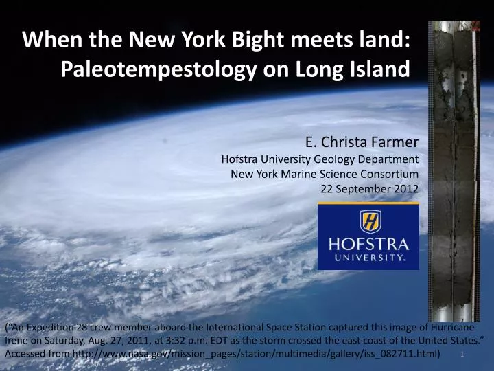
When the New York Bight meets land: Paleotempestology on Long Island E. Christa Farmer Hofstra University Geology Department New York Marine Science Consortium 22 September 2012 (“An Expedition 28 crew member aboard the International Space Station captured this image of Hurricane Irene on Saturday, Aug. 27, 2011, at 3:32 p.m. EDT as the storm crossed the east coast of the United States.” Accessed from http://www.nasa.gov/mission_pages/station/multimedia/gallery/iss_082711.html)
Why “Paleotempestology”?Why on Long Island? • “Paleotempestology” = study of ancient storms through geologic proxies • significant hurricane hazard in NYC-Long Island area • understanding long-term patterns and trends in storm frequency and intensity is important for making predictions of future activity and for preparedness (“An Expedition 28 crew member aboard the International Space Station captured this image of Hurricane Irene on Saturday, Aug. 27, 2011, at 3:32 p.m. EDT as the storm crossed the east coast of the United States.” Accessed from http://www.nasa.gov/mission_pages/station/multimedia/gallery/iss_082711.html)
Where in the world do hurricanes form? …they need sea surface temperatures (SSTs) greater than ~26°C NOAA World Ocean Atlas 2005, http://iridl.ldeo.columbia.edu/SOURCES/.NOAA/.NODC/.WOA05/
Locations of Hurricane Formation: “hurricane” = “tropical cyclone” = “typhoon” sea surface temperature (SST) > ~26 °C ~500 km (~300miles) diameter Figure from www.comet.ucar.edu/nsflab/web/hurricane/312.htm
Nine hurricane landfalls on Long Island since 1858 • most destructive was the “Long Island Express” of 1938: ~700 died; >$6.2m damage (in 1938 dollars) Carol 1954 1944 1893 Gloria 1985 1938 1894 Belle 1976 Donna 1960 1858 Figure from p. 8 of Tanksi, 2007, Long Island’s Dynamic South Shore, NY Sea Grant http://www.seagrant.sunysb.edu/cprocesses/pdfs/LIDynamicSouthShore.pdf
Do trends in sea surface temperature (SST) explain trends in number of major* hurricanes? (From Goldenberg et al. 2001) HIGHER SST (in the tropical Atlantic) LOWER SST (in the tropical Atlantic)
Do trends in sea surface temperature (SST) explain trends in number of major* hurricanes? Goldenberg et al. (2001) * “major” = category 3 or greater, or >50m/s (>110mph) maximum wind speed
Influence of global warming?? SST Power Index • Emanuel (2005) incorporated size of each storm into a “power” index (rather than just category, or maximum wind speed) • this power index seems to have increased remarkably in the last decade, along with sea surface temperature
Motivation for “Paleotempestology”: • hurricane records from satellites only go back a few decades • historical hurricane records are much less complete (because based on land- or ship-based observations) • longer records are needed to study decadal to millennial patterns (“An Expedition 28 crew member aboard the International Space Station captured this image of Hurricane Irene on Saturday, Aug. 27, 2011, at 3:32 p.m. EDT as the storm crossed the east coast of the United States.” Accessed from http://www.nasa.gov/mission_pages/station/multimedia/gallery/iss_082711.html)
The Geologic Record: ocean • theoretical map of barrier beach island and marsh behind beach • vertical profile of the transect • note “overwash fans” marsh beach Scileppi and Donnelly, 2007: Fig. 1
“Overwash” deposits: Animation courtesy of Jeffrey Donnelly, WHOI
Liu & Fearn (2000): • hypothesis: kinks in jet stream that change position of Bermuda High pressure system redirect hurricanes from Atlantic Coast to Gulf Coast on millennial timescales • expectation: when there are lots of storms hitting the Gulf Coast, there aren’t many hitting the Atlantic Coast, and vice versa (over the past several thousand years)
Comparison of several similar overwash deposit records: Scileppi & Donnelly (2007) Fig. 13
Gilgo003 Gilgo004 Gilgo002 Gilgo001 0 50 100 150 200 0 50 100 150 200 0 50 100 150 0 50 100 150 Fine sand Sand Cross- bedding clay Roots Peat Shells Graphic Sedimentary Logs for four cores collected from Gilgo Beach Marsh, Long Island, NY
Aerial photographs document locations of overwash deposits: • Aerial photographs were acquired from U.S. Army Corps of Engineers archives and www.neave.com. Modern Tiana Beach 2010 Tiana Beach Sept 1938 Tiana Beach June 1938
Research Priorities: • “sew up the coast”: replicate, replicate, replicate • can we corroborate “see-saw” or “pulsing” millennial trends for hurricane paths in the Atlantic Basin? (“An Expedition 28 crew member aboard the International Space Station captured this image of Hurricane Irene on Saturday, Aug. 27, 2011, at 3:32 p.m. EDT as the storm crossed the east coast of the United States.” Accessed from http://www.nasa.gov/mission_pages/station/multimedia/gallery/iss_082711.html)
Thanks! • Questions? • Acknowledgements: U.S. Department of Energy, Dr. J Bret Bennington, Courtney Melrose, Steven Leone, Tami LongJohn, Emma Kast, Ashley Persaud, Dr. Beth Christensen, Dr. Deb Freile, Dr. Jeffrey Donnelly, and many students who have worked with us on this project! (“An Expedition 28 crew member aboard the International Space Station captured this image of Hurricane Irene on Saturday, Aug. 27, 2011, at 3:32 p.m. EDT as the storm crossed the east coast of the United States.” Accessed from http://www.nasa.gov/mission_pages/station/multimedia/gallery/iss_082711.html)