Download
1 / 17
170 likes | 302 Views
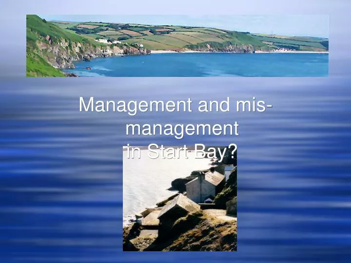
Management and mis-management in Start Bay?. Hallsands: as it was in around 1894 from a photograph by Messrs Valentine & Sons. The picture is thought to have been taken at high tide;

E N D
Hallsands: as it was in around 1894 from a photograph by Messrs Valentine & Sons. The picture is thought to have been taken at high tide; Hallsands: from a photograph taken in 1904 by R H Worth an engineer advising the fishermen. The loss of the shingle beach is obvious.
Hallsands – the end of a fishing village • The fate of the Hallsands, a fishing village in south Devon, with some 37 houses and 128 inhabitants was sealed in 1897 when work began on the construction of Devonport docks for the Royal Navy. • Large quantities of stone were needed, which appeared to be present in abundance offshore on the ‘Skerries bank’ in nearby Start Bay. Because of the potential effects to sea defences protecting nearby land, the terms of the licence included a clause allowing the licence to be revoked at short notice. • By 1900 the villagers of Hallsands noticed, as they anticipated, that the beach protecting the houses had begun to disappear. Damage to the houses resulted in the licence eventually being cancelled in 1902. • By then the damage was done and despite a respite for approximately 13 years, a storm in January 1917 destroyed most of the buildings and made those that survived uninhabitable and the villagers homeless.
Then and now…… 1885
Looking at Slapton Sands in isolation might suggest that protecting the coast is a feasible and sustainable option. • However looked at from a wider perspective it appears that there has been a tendency for the shingle beaches to erode around the periphery of Start Bay. It is not altogether clear if this is a relatively recent phenomenon, brought about in part by human actions or part of a long-term trend. • The evidence from Hallsands suggests that the beaches have always waxed and waned, though the loss of offshore shingle due to human interference seems to have tipped the balance to one of overall erosion. What seems certain is that there is little new sediment entering the bay.
Torcross village, July 2001, waves reached to the top of the houses during a storm in January 1979
Slapton Sands shingle bar is effectively a relict feature which was formed in immediate post-glacial times by the ‘Flandrian Transgression’ (post-glacial sea level rise) which pushed the predominantly flint and quartz shingle ridge onshore. The present shingle ridge and lagoon is the result of a 10,000 year progression which continues today.
The evolution of the shingle bar suggests that it will continue to migrate landward. This would seem to be part of a long-term trend which may have been accelerated with the removal of approximately 650,000 tons of shingle offshore, mostly from ‘Skerries Bank’ in the latter part of the 19th Century. This appears to have led to the loss of the small fishing village of Hallsands. The closure of the Hallsands Hotel and the progressive building of coastal defences at Beesands and along the foreshore of Slapton Sands may all be part of the same story. • Shingle beach in June 1990 looking south towards the central car park in the distance. • The situation in August 2002 when the eroding shingle beach had apparently dropped several metres, looking south from GR SX 829443 (note the height of the car park and the ‘protective’ structures in relation to the beach).
The A379 provides the principle means of access to this part of the coast from both Dartmouth in the northeast and Kingsbridge in the west. It is the most direct access to Dartmouth for Torcross residents and a through route for tourists. There is an apparent social and economic imperative to keep the road open and at the northern end, where the road had become undermined by the eroding beach it has been moved inland in response. • The old, and ‘new road’ to landward, looking north. • Note: just a year after being reopened storms, which battered the coast along Slapton Sands closed the main A379 road for one day, on Thursday 14th March 2002.
Hallsands HotelJust to the north of the lost fishing village of Hallsands, further along the coast lies a small embayment with a shingle shore. Overlooking the beach is a hotel. In the mid 1990s this was a 17 bedroom hotel advertising sub-aqua as well as other recreational facilities • The Hallsands hotel in the mid 1990s as advertised in the RSPB ‘Birds’ magazine. • Eroding beaches have caused the cliff, on which it is built, to be attacked by wave action. This resulted in the former footpath running to the left of the hotel becoming impassable and has been diverted to the right of the hotel. At the same time despite extensive ‘protective measures in August 2002 the hotel was boarded up awaiting demolition.
Beesands, a small village lying just north of Hallsands, in south Devon. In keeping with the other villages in Start Bay the beach has suffered from erosion. In January 1979 a severe storm threatened the whole community and could have eventually resulted in Beesands going the way of Hallsands some 100 years earlier. However in the late 1980s and early 1990s a major investment was made by the Government which reinforced the sea defences in a multi-million £ scheme • Beesands: Coastal protection along the village frontage where a concrete sea wall, rip-rap and beach nourishment have all been used to reflect storm waves and prevent flooding of the houses behind. • Comment: It is not certain if this problem represents a knock-on effect from the gravel extraction opposite Hallsands. However, it does appear to be a pattern which has and is being replicated around Start Bay including the Hallsands and Hallsands Hotel experiences, and these may provide a pointer to the likely outcome of the erosion of Slapton Sands.
The future of the road from Torcross to Dartmouth • It appears that the County Council took the decision to move the road following pressure from local people, especially businesses who feared its loss would affect trade. • At about the same time the county had money within the financial year to do the work so they did! English Nature agreed to the road being built on this occasion. • In order to avoid major conflict, a much better understanding of the processes taking place in Start Bay will be required. The results of this will also need to be disseminated widely within the local community as well as the decision makers at county and national levels. • It is recognised that the decision to move the road was taken in the absence of any long-term strategy. • In January 2001 when a storm badly damaged the road about 3,000 tonnes of boulders were placed to help protect it. The fact that they were later removed because of damage to the Site of Special Scientific Interest, suggests recognition of the value of the scientific interest of the system. • In order to look at the situation in a wider context and with a longer-term perspective, a scoping study has recently been completed. This reported on the nature of the problem, the impact on the local population, access to the area and the implications for the nature conservation interests. • Consultants have suggested hard defences may be needed in the short term, which could be removed at a later date. Incremental movement of the road as the beach recedes is also a consideration.