Download
1 / 23
240 likes | 392 Views
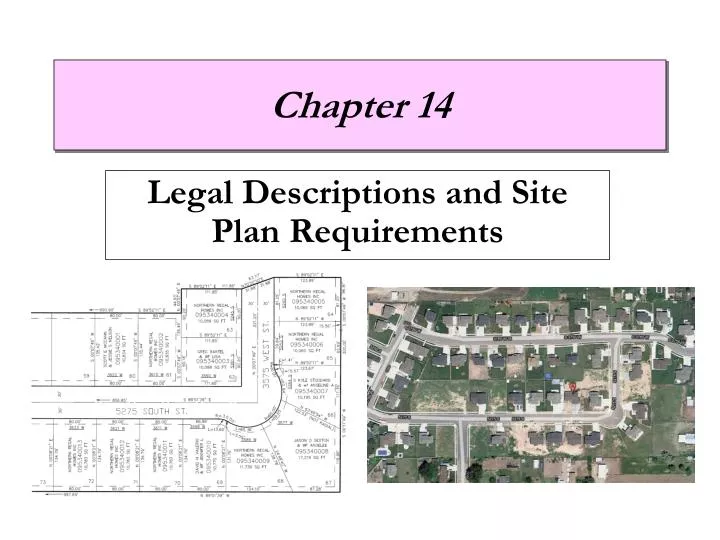
Legal Descriptions and Site Plan Requirements. Chapter 14. Overview. Legal Descriptions. Site Plan Requirements. Site Plans. Legal Descriptions. Legal descriptions are: Unique to every property Filed with local jurisdictions Public records

E N D
Overview Legal Descriptions Site Plan Requirements Site Plans
Legal Descriptions • Legal descriptions are: • Unique to every property • Filed with local jurisdictions • Public records • A site is generally referred to as a lot (Plot/ Site plan) • A plat map shows various lots in a subdivision
Legal Descriptions • Types of legal descriptions: • Metes and Bounds • Rectangular Survey System • Lot and Block Which system do we use in Utah?
Metes and Bounds • Metes is referred to as measurements • Measured in decimal feet, yards, rods, or surveyor’s chain • Bounds is referred to as boundaries • Boundaries refer to fences, tree lines, or river • Established by bearings • Begins with a monument known as point-of-bearing (POB) such as a rock, tree, or iron rod
Rectangular Survey System • Uses lines of latitude (horizontal parallels) and longitude (vertical meridians) to establish boundaries • Latitude - referred to as baselines (east and west) • Longitude - referred to as principal meridians (north and south)
Rectangular Survey System • Surveys break land into townships measuring 6 miles square • (36 square miles) • Townships were further divided into 1 square mile areas known as a sections • Each section is numbered from 1 to 36 • Sections are divided into 640 acres • 43,560 sq. ft. = 1 Acre • Sections can also be divided into quarters that contain 160 acres
Rectangular Survey System • Ranges were used to locate townships east or west of meridians • Section 9 of Township 3 North (How many miles north?) • Range 1 West (How many miles west?)
Lot and Block System • Each portion of land is divided into building lots • Lots vary in size depending on the property and owner • A subdivision contains many blocks that are further divided into lots How do Streets in Utah vs. outside of Utah vary? Anyone lived outside Utah?
Site Plan Starting Point • Topography - A physical description of the land showing elevations and other physical features
Site Plan Starting Point • Topography - A physical description of the land showing elevations and other physical features • Contour lines are used to show terrain • Close lines indicate a steep grade • Farther lines indicate a gentle grade • The contour interval is the vertical distance between contour lines
Site Plan Requirements • Legal description of the property based on a survey • Property line bearings and directions • North Direction • Roads and easements • Utilities • Elevations • Map scale
Complex Site Plan Requirements • Legal description of the property based on a survey • Property line dimensions • North Direction • Roads and easements • Utilities • Elevation markers • Floors • Ground • Map scale • Grading Plan • Drainage Direction • Cross section
Site Analysis Plan • Site analysis plan shows the relationship of the proposed site to adjacent sites including: • A vicinity map with scale and north direction • Site features with boundaries • Traffic and pedestrian patterns • Contour lines • Solar orientation and prevailing winds
Planned Unit Development • A vicinity map is used to show large areas and the location of the development • Multi-use/ zoning uses
Planned Unit Development ( http://www.daybreakutah.com/assets/files/homefinder_map.pdf )
Our Site Plan Requirements • Setbacks (Set by city) • 25’ Front • 20’ Side on Corner Lots • 30’ Rear • 10’ Sides • PUE- Public Utility Easements • Drawn on each lot already