Download
1 / 18
260 likes | 609 Views
Raster Data in QGIS. Matthew Rosencrans Tom DiLiberto. Outline . What is Raster Data? Supported Formats What can one do with Raster Data?. Raster Data. Raster Data = gridded data NWP Model Output Imagery LDAS outputs LIDAR/RADAR Interpolated fields from point/line/polygon data.

E N D
Raster Data in QGIS Matthew Rosencrans Tom DiLiberto
Outline • What is Raster Data? • Supported Formats • What can one do with Raster Data?
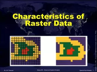
Raster Data • Raster Data = gridded data • NWP Model Output • Imagery • LDAS outputs • LIDAR/RADAR • Interpolated fields from point/line/polygon data
Raster Data • QGIS uses GDAL libraries • GDAL = Geospatial Data Abstraction Library www.gdal.org
Supported Formats • ArcInfo Grid (ASCII or Binary) • GeoTIFF/GeoPDF • ERDAS IMAGINE/ ENVI • GIF/JPG/PNG • netCDF HDF4/5 • NGSGEOID • USGS DEM • OGC formats • Grib2 • http://www.gdal.org/formats_list.html
Raster Data • What good is data without interpretation? • Need to colorize/stylize/query
Symbologies • Singleband • Psuedocolors • Multiband
Symbologies • Pseudocolor • Scalar fields • Temperature • Precipitation • Satellite Index Decide your thresholds Choose colors Apply
Creating Raster Data • Interpolation of point data • Multiple methods • Inverse distance weighted (CPC) • Natural Neighbor (used by CPC and USDA) • Kriging • SAGA GIS - open source for making Gridded Data
Creating Raster Data • Inverse distance weighted (CPC) • Power Value • higher = emphasis on the nearest points, less smooth • lower = emphasis on further points, smoother • Control number of points • Non physical
Creating Raster Data • Natural Neighbor (used by CPC and USDA) • Voronoi (Thiessen) polygons constructed • Sample point, new Thiessen polygon constructed • Weight = proportion of overlap new/initial poly
Creating Raster Data • Kriging • SAGA GIS – Some issues with software • Assumes distance or direction between sample points can be used to explain variation in the surface • forms weights from surrounding values to predict unmeasured locations
Raster Processing • Raster Processing • Clipping – GDAL Clip Raster By Extent. • Instead of masking out ocean, or able to subset for country or province • Extracting • Point Sampling • Extracting by value • Resampling (helps to match resolution) • Mathematical operations within and across rasters • Raster Addition/subtraction • Creating Totals, Climatologies, Anomalies • Local Statistics (Zonal Statistics)
Raster Processing • Raster Processing • Clipping – GDAL Clip Raster By Extent.
Raster Processing • Raster Processing • Extracting • Point Sampling –QGIS Plugin or SAGA tool • Extracting by value
Raster Processing • Raster Processing • Resampling (helps to match resolution)
Raster Processing • Raster Processing • Mathematical operations within and across rasters • Raster Addition/subtraction • Creating Totals, Climatologies, Anomalies • Local Statistics (Zonal Statistics) • Covered in Day 3
Raster Processing • Lab Work will cover • Symbolizing Rasters • Querying rasters • Clipping • Raster Calculator • Calculations • Interpolations • Querying rasters at points