Download
1 / 36
360 likes | 369 Views
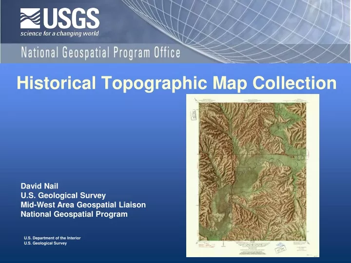
Historical Topographic Map Collection. David Nail U.S. Geological Survey Mid-West Area Geospatial Liaison National Geospatial Program. Historical Topographic Map Collection Overview. Background Conversion and Catalog Use Status Search and discovery. Historical Topographic Map Collection.

E N D
Historical Topographic Map Collection David Nail U.S. Geological Survey Mid-West Area Geospatial Liaison National Geospatial Program
Historical Topographic Map CollectionOverview • Background • Conversion and Catalog • Use • Status • Search and discovery
Historical Topographic Map Collection Definition of Terms U.S. Topo Historic Topo Map The National Map
Historical quadrangles can serve as chronological layers supplementing the new US TOPODocuments the changes over time. Original drivers for creating an electronic Topographic Map Collection
Original reasons for converting this Collection • Long-term record and • documentation of the • natural, physical and • cultural landscape. • The potential for analysis of • distribution and spatial • patterns is invaluable • throughout the sciences and • non-science disciplines. • For more than 125 years, the USGS topographic mapping program has accurately portrayed the complex geography of our nation.
Creating a comprehensive catalog • These maps are either long forgotten or are not known • to have existed. • Most are no longer available for distribution in print. • No single complete set is known to exist – anywhere.
Goals for historical USGS quadrangle scanning • Scan approximately 180,000 printed quadrangles – all maps, all scales. Historical quads are all printed maps prior to US TOPO. • Use consistent, high quality specifications • Provide all editions, all scales • Georeference the maps • Release through the USGS Store and The National Map Viewer
Goals for historical USGS quadrangle scanning • A complete copy of all metadata and digital files will be available from USGS. • Copies will be housed at the National Archives and Records Administration as well as the Library of Congress, Geography and Maps Division. • Copies of pertinent segments of the collection may be housed in local map libraries, research institutes and other government offices. • All files will be in the public domain.
Automated geo-referencing software available from the University of Wisconsin http://www.geography.wisc.edu/research/projects/QUAD-G/
First release for this Collection – GeoPDF files Reference Download and print
First release for this Collection – GeoPDF files • TerraGo Toolbar: • GeoTool – Locks/unlocks coordinates, Google™ Map It, and launches other GeoPDF tools. • GeoLocator – Shows and finds coordinates and provides the ability to modify coordinate system displays. • GeoMeasure – Measures either length or area. • GeoTrack – Displays the current position of an attached GPS device.
Metadata Availability FGDC compliant: GeoPDF attachments
User need: Original files with full collar information for Geographers, Spatial Analysts or Core Professionals Product: Full resolution, full sheet TIFF images with full metadata and georeference transformation file
Historical Quads Example Use:Change Over Time 1956 1965 • Lake Monroe, IN • Impoundments
Historical Quads Example Use:Change Over Time • Lake Monroe, IN • Timber 1999 1965
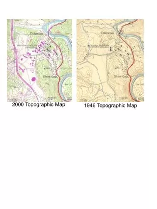
1908 Historical Quads Example Use:Change Over Time • Bloomington, IN • Urban growth 1998
Historical Quad Examples Special Edition non-standard quads
Cities San Francisco 1899 1:62500 Chicago Loop 1929 1:24000
Indiana’s Oldest Maps St. Meinrad 1900 1:62500 Tolleston 1900 1:62500 De Gonia Springs 1900 1:62500
Search and Discovery IU Spatial Data Portal USGS Store
Search and Discovery USGS Store Google Search by typing: “USGS Store” and click on the “Map Locator” option in search results. Or try the shorten URL link: http://on.doi.gov/aAAZqa
Search and Discovery USGS Store Search by Place, Address or by Quad Name.
Search and Discovery USGS Store • Click red-balloon marker to display a list of quads • Hover mouse over column headings for more info • Click elsewhere on the GoogleMap application to place additional red-balloon markers • Download TerraGo toolbar
For additional information: http://nationalmap.usgs.gov/historical
Allens Creek 24K, 7.5 min. Mapped 1943 Pub. 1947
Allens Creek 24K, 7.5 min. Mapped 1943 Pub. 1953
Artist: Hal Shelton Circa 1940