Download
1 / 8
150 likes | 585 Views
The Geography of Ancient Rome. So… Why are we learning this?. Well.. There are still many cultural connections among Mediterranean areas of Europe, Asia, and Africa as a result of Rome’s influence. And Geography has an important part to play in this influence…. A question for you!.

E N D
So… Why are we learning this? • Well.. • There are still many cultural connections among Mediterranean areas of Europe, Asia, and Africa as a result of Rome’s influence. • And Geography has an important part to play in this influence…
A question for you! • By the time we finish today, you should be able to answer this question. • Why was Rome’s location so favorable?
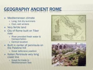
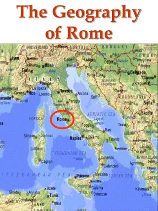
Geographic Landmarks • Italy is a peninsula in the Mediterranean Sea. (Its most prominent feature is its boot-like shape kicking the island of Sicily.) • FYI: A Peninsula is land surrounded on three sides by water. (What are those waters? Look at your map!) • Why is this good? • Roman ships could easily sail to other lands • This helped them conquer new lands and develop trade routes.
Another Landmark • Much of Italy is covered by mountains. • The Dolomite mountains which extend across northern Italy are part of the Alps mountain range. • The Apennine mountains cut down the center of Italy, stretching from north to south, dividing the east and west coasts. • Why is this important? • Protection, but it didn’t isolate Rome from the rest of the world.
More landmarks!!! • The Po Valley, just south of the Dolomite mountains, is the basin of the Po River. • It is fertile farm land, which made farming in Rome easier than in Ancient Greece. • Italy includes two large islands: Sicily and Sardinia. • Sicily is the largest island in the Mediterranean, with active volcanoes and earthquakes. • Sardinia is basically mountains rising out of the ocean.
Climate • Rome (and today’s modern Italy) has two climate regions. • In northern Italy, temperatures can reach below the freezing during the winters, with snow in the northern most areas. • It’s climate is much more like what you would see in countries like Germany or Belgium. • Southern Italy has a warmer, more moderate climate. • Much more like Spain, Greece, Turkey.
So… Back to our question! • Why was Rome’s location so favorable? • Here’s another view: • Read the handout/reading Rome’s Perfect Location • Answer the reading review questions on a Separate piece of paper. Due: NEXT CLASS (Friday!)