Download
1 / 86
860 likes | 1.02k Views
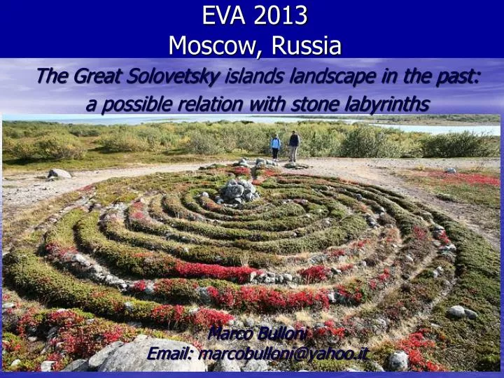
EVA 2013 Moscow, Russia. The Great Solovetsky islands landscape in the past: a possible relation with stone labyrinths Marco Bulloni Email: marcobulloni@yahoo.it. VIRTUAL ARCHAEOLOGY & RECONSTRUCTIONS. This study regards an island and its past, and is an attempt to create

E N D
EVA 2013 Moscow, Russia The Great Solovetsky islands landscape in the past: a possible relation with stone labyrinths Marco BulloniEmail: marcobulloni@yahoo.it
VIRTUAL ARCHAEOLOGY & RECONSTRUCTIONS This study regards an island and its past, and is an attempt to create a synergy between archaeological findings and virtual landscape reconstruction
WHERE IS THE ISLAND ? The Russian White sea
WHERE IS THE ISLAND ? Kola Peninsula The Solovetsky Archipelago Carelia Plain Arkanghesk Region
WHERE IS THE ISLAND ? The Artic Circle The Solovetsky Archipelago
WHERE IS THE ISLAND ? Anzer island The Great Solovetsky island Kuzova islands Zayatsky island
WHERE IS THE ISLAND ? The island object of this study Great Solovetsky Island
THE ISLAND Coastal lines are not very well defined
THE ISLAND Sea Peat 800 Lakes Water and marsh are almost everywhere
THE ISLAND Beautiful landscape in a wild and gentle territory
WHAT DO WE KNOW ? 7600 BP Today From Prehistory to History
WHAT DO WE KNOW ? 1 5000 BP 7600 BP Today First human settlements on the White Sea and Anzer island
WHAT DO WE KNOW ? 1 2 5000 BP 3000 BP 7600 BP Today The White Sea Culture (WSC) inhabited the islands First human settlements on the White Sea and Anzer island
WHAT DO WE KNOW ? 1 2 3 5000 BP 3000 BP 600 BP 7600 BP Today The White Sea Culture (WSC) inhabited the islands Sporadic human presence on the islands First human settlements on the White Sea and Anzer island
WHAT DO WE KNOW ? 1 2 3 4 5000 BP 3000 BP 600 BP 7600 BP Today The White Sea Culture (WSC) inhabited the islands Sporadic human presence on the islands Monastic period First human settlements on the White Sea and Anzer island
THE WHITE SEA PREHISTORY Stone alignments on the Kuzova islands Photo: V. Nikolaenko
THE WHITE SEA PREHISTORY Photo: V. Nikolaenko Monolithic stones on the White Sea shores Photo: V. Nikolaenko
THE WHITE SEA PREHISTORY Petroglyphs on the Carelian sea coasts The WSC was technologically evolved
THE WHITE SEA PREHISTORY Uncommon navigational skill and well organized
THE WHITE SEA PREHISTORY Very interesting petroglyphs
THE SOLOVETSKY ARCHIPELAGO Due to its great historical and archaeological value: 1) in 1967 a department devoted to the islands was created, known as “Solovki State historical, architectural and natural museum-reserve” 2) in 1994 the whole archipelago was inscribed in the “UNESCO World heritage list”
THE REAL QUESTION: Why in the last 30 years, 50.000 archaeological findings have been found on the nearest islands, and 0 on the Great Solovetsky ?
THE POSSIBLE ANSWERS • Up to now is has not yet possible to explore Solovetsky island due to logistic difficulties , lack of funds, priorities; • Archaeologists have not been helped by geologists in order to select the right Solovetsky places to explore; • One theory suggests that the island was a holy place: for this reason there is no evidence of human settlements; • Most of the archaeologists say that the island was under the sea, so it has not been inhabited in the past. • This study wants to reduce uncertainty related to the answers
THE ISLAND COVERED BY ICE The structure of the island remained covered by ice until 12.000 years ago (the end of the last glacial era) Island Limit of ice during The last glacial era
THE ISLAND ARISE FROM THE SEA With the end of the last glacial era, the island started to emerge from water due to the so called “isostatic rebound”.
THE METODOLOGY USED SOLOVETSKY 40 kms Assumption: the data for Kuzova island can also be used for Solovetsky island KUZOVA
THE SOLOVETSKY ARISE Data: NASA ASTER GDEM V002
THE SOLOVETSKY INCREASE The Solovetsky archipelago gradually increased its size from zero to the actual dimensions of 320 Square kms
THE YEAR OF FIRST HUMAN PRESENCE 7.600 YBP Anzer island Solovetsky island
THE WHITE SEA CULTURE ARRIVAL 5.000 YBP Anzer island Solovetsky island
THE WHITE SEA CULTURE DEPARTURE 3.000 YBP Anzer island Solovetsky island
SOLOVETSKY AND HUMAN PRESENCE In presence of human beings, the sea changed its level at the velocity of 30 cm / 100 y
THE SOLOVETSKY INCREASE • My hypothesis: ancient people were conscious of this raise: • The raise velocity of 30 cm / 100 y was constant for at least 4.600 years; • The people leaving on the islands where mainly fishermen and sailors who build settlement on the sea shores; • Any kind of canal or little port, built for repairing boats, need to be rebuilt from one generation to another; • In 4.600 years of human presence, the island increased 4,5 times its initial dimensions; • These facts could have not been ignored by human beings. • Can we look for proofs about an island arising from waters?
THE LABYRINTHS On the islands of the archipelago many stone labyrinths have been found. In particular, three of them are of great interest, on Zayatsky island
THE LABYRINTHS An aerial view of the labyrinths
THE LABYRINTHS The first labyrinth, the biggest, is 24 meters wide
THE LABYRINTHS The third labyrinth will be studied in detail
THE LABYRINTHS It presents some particular aspects and entrance
THE LABYRINTHS • Russian Archaeologists associate them to the WSC for many reasons, above them: • They have been built near the sea shore level of 3.000 YBP, when the WSC ended; • In the circles of the labyrinths some stone arrows have been found similar to those used by the WSC; • In the vicinity of the labyrinths many archaeological findings have been found, related to the WSC settlements;
THE LABYRINTHS Many interpretations of their function were made
THE LABYRINTHS I associate the labyrinth to the Solovetsky shape
THE LABYRINTHS Let us qualitatively describe the labyrinths
THE LABYRINTHS DESCRIPTION 3) A discontinuity point 2) The entrance shape 1) The entrance orientation We can describe a labyrinth with 9 elements
1) THE ENTRANCE ORIENTATION 135° All the 3 stone labyrinths present the entrance orientation as SolovetskyDolgaya bay
2) THE ENTRANCE SHAPE The entrance is long, narrow and radial, as the Dolgaya canal on the island