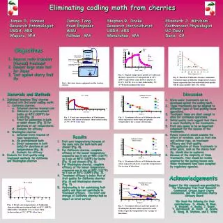
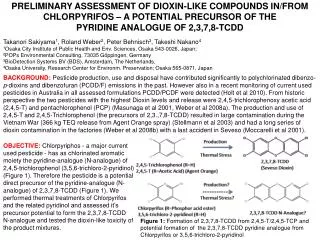
Download

1 / 29
290 likes | 389 Views
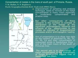
Materials and Methods. Number of monitoring sites and area types overall Egypt. Instruments and measurements techniques used in the air quality monitoring network. Shoubra. Abbaseya. Cairo city centre. Giza.

E N D
Instruments and measurements techniques used in the air quality monitoring network
Shoubra Abbaseya Cairo city centre Giza Air Quality Monitoring NetworkA full description of the selected monitoring sites (8 sites) used in the study • Shoubra El Kheima • Area description Highly industrial, very polluted, several small smelters and various industries. • Local Sources Lead smelters to the west, north and east of the school, within a few hundred meters. • Representativity Very polluted industrial area. • Data show the impact of industries on the building. • Paramters measuredSO2, NO2, TSP, PM10
Abbassyia site • DescriptionRegional residential area normally up-wind from Cairo city center, but down-wind from the Shoubra industrial area and Shoubra urban area. • Local Sources: No immediate local sources, but regionally exposed. • Representativity:Regional urban area. • Paramters measuredSO2, NO2, O3 and Meteorology Measurement
Qulaly site • Area description:Urban center with dense traffic on the street coming from shoubra and crossing streets into Al Qulaly and to Ramses Station. • Local Sources: The area is expected to be highly polluted from traffic in the main railway station area of Cairo. There are small industries north of the site and the whole Shoubra area is located upwind in prevailing wind direction. • Representativity:urban central part of Cairo. • Paramters measuredSO2, NO2, PM10, TSP, and VOC.Measurement
El Gomhoria site description • Description:Street canyon in urban area with heavy traffic. • Local Sources:Mainly traffic in the general area and around Ramses square (about 300m from the site). Heavy traffic on Gomhoryia street just under the sampler intake. • Representativity:Representative for street canyons in central Cairo. • Paramtersmeasured SO2, NO2, CO, PM10
Fum El Khalig site description • Description:Urban center roadside monitoring station with dense traffic on the streets on both sides of the site. • Local Sources:The area is expected to be highly polluted from traffic • Representativity:Representative for the urban central part of Cairo and specifically near two main roads. • Paramters measuredSO2, NO2, CO
Maadi Site description • Description:Residential • Local Sources: Mainly Traffic and general activities of people. • Representativity: Typical for western Maadi area, near street surrounded by tall trees (slightly more traffic impacted than inside residential Maadi). • Paramtersmeasured SO2, NO2
Tabbin Site description • Area description: Industrial, polluted from several cement factories and others north of the site, and smelters and chemical industries to the south. • Local SourcesSmelters, steel and iron factories, coke factory within 1 Km to the south, cement factories in the sector north-west to north-east. • Representativity:Very polluted industrial area. • Data is showing the impact of industries on the building. • Paramters measuredSO2, NO2, TSP, PM10 dustfall and meteorology Measurement.
10 Ramadan station 10th of Ramadan site description • Area description:Some smaller industries 1-km to the north (upwind). Some industries to the west, but the major industries park is located to the south and south east; 2-3 km away. • Not expected to be a polluted area. • Representativity:Residential area. • Paramtersmeasured: SO2, NO2 and PM10 and dustfall.
Dispersion Model Description POLAIR • The POLAIR modeling has the fuctionality to simulate the atmospheric dispersion of gaseous polluting agents and fine particles from diverse sources. With the help of mathematical equations, • POLAIR can help study the impact of emissions in zones subject to atmospheric pollution. • The results are easily interpreted with graphical views depicitng color graded graphs.
Plume’s superelevation models Three models are availble to estimate the concentration by dispersion modeling • The U.S. Environmental protection Agency (EPA)’s superelevation model; • Holland’s superelevation model; • Communauté Urbaine de Montréal’s (CUM) regulatory superelevation model. • For the majority of study case scenarios, it is highly recommended to use the regulatory EPA model. It takes into account each of the varaibles for the plume’s superelevation and better represents reality.
Plume’s atmospheric dispersion modelGaussian model and associated parametersThe Gaussian model is the most used in the world to study dispersion phenomena. This model estimates the pollutants’s concentration in spatial points while taking into account the following factors: the emission’s characteristics, the receiving environment and the meteorolgical conditions.
Compound under study POLAIR model offers a database on physical, chemical and toxicological properties. The avaiable information is as follows: • Name of chemical compound; • Chemical formula; • Molecular weight; • Terminal velocity (can be used at 0m/s as the majority of gases have a density similar to air. This is not the case for particles and heavy metals); • Thershold of smell preception; • Inferior limits for explosion and flammability; • Toxcity threshold; • Concentrations profile.
Types of simulation • Simulation results can be shown in results in several types of data presentations. The types of simulation can be seen in the results are as follows: • With maxima • First hourly maximum; • Second hourly maximum; • Mean concentration on 2h, 4h, 8h and 24 hours. • Perecentages of threstholds; • Hourly arithmetic mean concentration.
Simulation with threshold overshoot • The simulation with threshold overshoot indicate in percentage, the proportions of calculated values that have exceeded the set threshold of concentration. In accordance to the receiving point. The threshold was set according to the maximum permissible values in indicated in the Egyptain Environmental law no. 4/1994.
Passive and hand held samplers • Passive samplers have been used for Model verfication along different distances (200m – 2000 m) for some of the monitoring sites (Tabbin- Maadi –Qualaly and Abassyia). • Passive samplers is used for surveillance of time integrated SO2 and NO2 concentration distributions. • They have been analyzed in the laboratory after exposure in the field for typically one week.
POLAIR dispersion model performance results for SO2 concentrations prediction using national monitoring stations network in Greater Cairo during 2004
Distribution of annual mean SO2 concentrations in µg/m3 calculated with POLAIR dispersion model using (2004) SO2 concentrations from the national monitoring network at Abassyia site
Distribution of SO2 concentrations over shooting (150 µg/m3 per 24 hours) calculated with POLAIR dispersion model using (2004) SO2 concentrations from the national monitoring network at Abassyia site
Distribution of SO2 concentrations over shooting (150 µg/m3 per 24 hours) calculated with POLAIR dispersion model using (2004) SO2 concentrations from the national monitoring network at Qualaly site
Annual mean SO2: observations versus predictions at some monitoring sites in Greater Cairo during 2004