Download
1 / 9
90 likes | 157 Views
Road Centerline Project Update. Lyle Hornbaker Local Government GIS Manager Virginia Geographic Information Network April 3, 2007. expect the best. www.vita.virginia.gov. 1. Agenda. Status of Receiving “True-up” Files. Outlining the Effort. Many players Many situations

E N D
Road Centerline Project Update Lyle Hornbaker Local Government GIS Manager Virginia Geographic Information Network April 3, 2007 expect the best www.vita.virginia.gov expect the best 1
Agenda • Status of Receiving “True-up” Files. • Outlining the Effort. • Many players • Many situations • Keeping The Data Current • MOU • Future plans expect the best
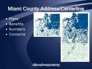
Status of Receiving “True-up” Files • Because of the nature of roads and addresses, the Road Centerline Project is a dynamic effort and must be kept current. • We are now working on the final update effort before moving the project in “steady state maintenance.” • As of March 7, 2007, approximately 34% of the jurisdictions had been updated at least once. • As of April 3, 2007, 60% of jurisdictions have been collected for updating. expect the best
Status of Receiving “True-up” Files expect the best
Outlining the Effort • Most of the geometry of the Road Centerline Project came from the 2002 orthophotography but a good deal of the value of the project is in the attributes • Street names and addresses must be provided by the locality • Once street segments are identified, other data can be attached to them. • The project integrates the efforts of 95 counties, 39 cities, 23 towns and VDOT. expect the best
Outlining the Effort Project “Choreography” 134 Cities and Counties + 23 Towns + 1 VDOT = 158 partners to the Road Centerline “Dance” VDOT expect the best
Outlining the Effort • 158 Partners = 158 unique situations. • Ability to participate is based somewhat on the “maturity” of the GIS in the jurisdiction. • Some are easy participants. • Some are difficult. • We still need the data. expect the best
Keeping The Data Current • The success of the project relies on a constant flow of information. We do this in two ways. • Ensure buy-in from the partners (MOU). • Ensure a tangible benefit for all those involved (easy access to data, useful product, etc). • Future Plans. • Automated access. • Building the success by promoting it’s use. expect the best
Conclusion Questions? expect the best