Download
1 / 27
360 likes | 935 Views
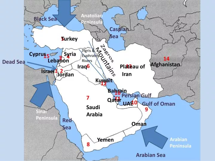
Anatolian Peninsula. Black Sea. Caspian Sea. Turkey. 5. Tigris & Euphrates Rivers. Cyprus. Syria. 15. 4. 3. 14. Zagros Mountains. Lebanon. Dead Sea. Afghanistan. 6. 13. Iraq. Plateau of. 1. 2. Israel. Iran. Jordan. Kuwait. 12. Bahrain. 16. Persian Gulf. 7. 11.

E N D
Anatolian Peninsula Black Sea Caspian Sea Turkey 5 Tigris & Euphrates Rivers Cyprus Syria 15 4 3 14 Zagros Mountains Lebanon Dead Sea Afghanistan 6 13 Iraq Plateau of 1 2 Israel Iran Jordan Kuwait 12 Bahrain 16 Persian Gulf 7 11 Qatar 10 UAE Gulf of Oman Saudi Arabia 9 Sinai Peninsula Red Sea Oman Yemen Arabian Peninsula 8 Arabian Sea
Major Landforms of the region • This region forms a land bridge connecting Asia, Africa, and Europe. • The Middle East is situated on a huge tectonic plate causing it to pull away from Africa
Occupiedby Turkey, the Anatolian Peninsula marks the beginning of the Asian continent Not occupied by a bunch of these… …The country of Turkey!!!
Arabian Peninsula Most distinctive landform is the Arabian Peninsula. Separated from Africa by the Red Sea and the rest of Asia by the Persian Gulf
ImportantWaterways • Canal = man-made waterway connecting 2 bodies of water • Strait= naturally occurring waterway connecting 2 bodies of water
Suez Canal • Links Mediterranean Sea to the Red Sea • Completed by the British in 1869
Why are these waterways so important? Russia Europe Strait of Hormuz Bosphorus Strait Suez Canal
What is unique about this waterway? Strait of Hormuz I’ll give you a hint… There is an abundance of a certain natural resource located right here Pathway to LOTS of OIL!!!
Much of the Arabian Peninsula is covered by barren plains. “Even I’m thirsty.” • For centuries, people living on the Arabian Peninsula had to adapt to the harsh conditions by living nomadic lives in search of water
The heart of Iran is a plateau bordered by the Zagros Mountains.
Which country is completely land-locked? • What issues might this cause?
How can mountains and deserts be useful to people??? • A natural barrier to protect from foreign invaders I’m thirsty. This is tough…
A Versatile Land • People picture Southwest Asia as a region of rippling sand dunes and parched land occasionally interrupted with an oasis. • Southwest Asia actually has a range of physical geography from green-coastal plains, to snow-peaked mountains. Golan Heights Golan Heights- Hilly plateau looking over the Jordan River and the Sea of Galilee. This landforms strategic location has made it the site of conflict in Southwest Asia for decades.
Plains and Highlands • Much of the Arabian Peninsula is covered by plains. • Because of the dry, sandy and windy conditions, few activities using the land take place here. • Most of the land is barren with some low hills, ridges, and wadis (riverbeds that remain dry except during the rainy seasons).
The most famous desert… * The size of Texas on the Arabian Peninsula Rub al-Khali:“The Empty Quarter” AKA…the place where no one comes out.
Water in the Middle East • Almost completely surrounded by water but because much of the region is arid, there are few rivers that flow the entire year.
The Tigris & EuphratesRiver System The two most important rivers are the Tigris and Euphrates Rivers Mesopotamia: ”Land Between the Two Rivers” aka the Fertile Crescent
Tigris and Euphrates • Flow through parts of Turkey, Syria, and Iraq • Makes land very fertile and good for agriculture. • Flow almost parallel for hundreds of miles before joining at a place called Shat al Arab.
Jordan River • The Jordan River empties into the Dead Sea • Natural boundary between Jordan and Israel
Dead Sea: Lowest Point on Earth 2,300 feet below sea level HighestSaltContent(33%) *9x saltier than ocean
Climate of the Middle East • Extremely arid • Most areas receive less than 18 inches of rain a year! • Mediterranean climate (along the coasts) are in other parts of the region making the land green and lush for parts of the year.
Irrigation Systems • Water is the most precious resource so water usage is one of the many international conflicts in the region. • Irrigation/dam systems are controversial because countries downstream will lose use of the water for irrigation and hydroelectric power.
Oil • Oil fields in Middle East hold ½ of all petroleum reserves in the world! • Oil is transported mostly by carefully monitored above and underground pipelines
Something to think about? • Saudi Arabia is the world’s largest producer of oil. Oil revenues make up 90-95% of the export earnings and around 35-40% of the country’s GDP. In the first 8 months of 2000, Saudi Arabia provided the U.S. with 1.5 million barrels of oil per day. • Do you think the United States should protect Saudi Arabia in a time of war to protect U.S. oil interests?