Download
1 / 6
60 likes | 155 Views
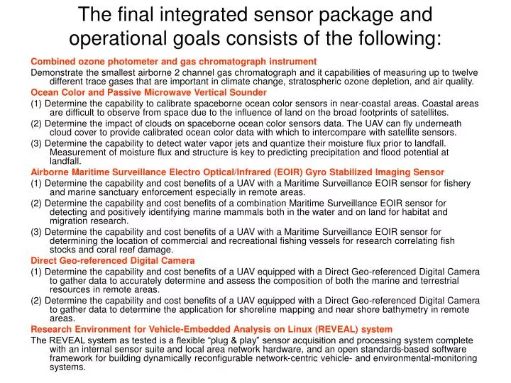
The final integrated sensor package and operational goals consists of the following:. Combined ozone photometer and gas chromatograph instrument

E N D
The final integrated sensor package and operational goals consists of the following: Combined ozone photometer and gas chromatograph instrument Demonstrate the smallest airborne 2 channel gas chromatograph and it capabilities of measuring up to twelve different trace gases that are important in climate change, stratospheric ozone depletion, and air quality. Ocean Color and Passive Microwave Vertical Sounder (1) Determine the capability to calibrate spaceborne ocean color sensors in near-coastal areas. Coastal areas are difficult to observe from space due to the influence of land on the broad footprints of satellites. (2) Determine the impact of clouds on spaceborne ocean color sensors data. The UAV can fly underneath cloud cover to provide calibrated ocean color data with which to intercompare with satellite sensors. (3) Determine the capability to detect water vapor jets and quantize their moisture flux prior to landfall. Measurement of moisture flux and structure is key to predicting precipitation and flood potential at landfall. Airborne Maritime Surveillance Electro Optical/Infrared (EOIR) Gyro Stabilized Imaging Sensor (1) Determine the capability and cost benefits of a UAV with a Maritime Surveillance EOIR sensor for fishery and marine sanctuary enforcement especially in remote areas. (2) Determine the capability and cost benefits of a combination Maritime Surveillance EOIR sensor for detecting and positively identifying marine mammals both in the water and on land for habitat and migration research. (3) Determine the capability and cost benefits of a UAV with a Maritime Surveillance EOIR sensor for determining the location of commercial and recreational fishing vessels for research correlating fish stocks and coral reef damage. Direct Geo-referenced Digital Camera (1) Determine the capability and cost benefits of a UAV equipped with a Direct Geo-referenced Digital Camera to gather data to accurately determine and assess the composition of both the marine and terrestrial resources in remote areas. (2) Determine the capability and cost benefits of a UAV equipped with a Direct Geo-referenced Digital Camera to gather data to determine the application for shoreline mapping and near shore bathymetry in remote areas. Research Environment for Vehicle-Embedded Analysis on Linux (REVEAL) system The REVEAL system as tested is a flexible “plug & play” sensor acquisition and processing system complete with an internal sensor suite and local area network hardware, and an open standards-based software framework for building dynamically reconfigurable network-centric vehicle- and environmental-monitoring systems.
Trace Gas Measurements CMDL Ozone Instrument • Flight over Canada for CO2 study on June 12, 2003 • Ozone stratospheric tracer • Nitrous Oxide tropospheric tracer • Inversely Correlated CMDL 2 channel Gas Chromatograph
NOAA Airborne Ocean Color Mapper Fisheries applications of airborne ocean color sensing includes chlorophyl-a and sea surface temperature mapping for primary production measurements. Regions of application include coastal and subtropical convergence zones. < Example of chl-a data from manned aircraft flights of ETL ocean color sensor around Alaskan coastal waters, May 2003. UAV operation is needed to provide the persistence necessary to map through cloud cover holes. ETL ocean color sensor suite as configured for planned Altair flights in February, 2004. Specifications: Weight ~20 lbs Power ~50 Watts
NOAA Passive Microwave Vertical Sounder for PacJet 55 GHz 89 GHz 183 GHz NOAA/ETL spectrometer modules with internal fast-switched absolute calibration. Above spectrometers (plus two more under development) provide full AMSU-A/B and NPOESS CMIS and ATMS tropospheric sounding compatibility. Microwave sounders as installed in NOAA PSR/S airborne radiometer sensor