Download
1 / 5
50 likes | 151 Views
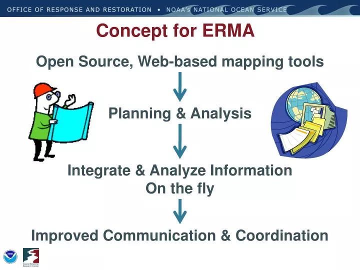
Concept for ERMA . Open Source, Web-based mapping tools. Planning & Analysis. Integrate & Analyze Information On the fly. Improved Communication & Coordination. Output to User Download/Upload Source. Feature Server Tools. ERMA Architecture. ESI & IPaC Query. AIS Ship Search.

E N D
Concept for ERMA Open Source, Web-based mapping tools Planning & Analysis Integrate & Analyze Information On the fly Improved Communication & Coordination
Output to User Download/Upload Source Feature Server Tools ERMA Architecture ESI & IPaC Query AIS Ship Search Open Layers Web Mapping Service (Feature) • External GIS Data • ENCs/ RNCs • Real Time Weather Obs • Buoys • NAIS/ AFF/AMOC Secure Server Authentication Data Layer Management Access Privileges • Response datasets from SFTP • Trajectories • Satellite Interpretations for oil • SCAT Results • Overflight Planed & Obs • Booms plans/derived from imagery • Protected Resource Impact • Field sampling (subsurface, analytical chemistry, etc.) • Platform observations MapServer • Base Public datasets • ESI • Landuse • Bathymetry • Regional Monitoring • Habitat Classifications • Restoration • Bioresource Base data PostGres/ PostGIS Data Base (Full Backup routinely)
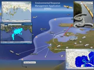
Site Overview • Weather & Buoys Observations • Real-time feeds • Hurricane/Storms • Remote-sensing Imagery • Resources at Risk • NOAA ESI data layers • Fisheries Closures • Local habitat and species datasets • Seafood Safety • Marine Protected Areas • Document & photo links • ESI and GRPs PDFs • Field Photos • External links • Secure access • Username/Password • Various levels of access (Public, Responder, NRDA, Trustee) • Background Layers • Google aerial, terrain, roads • Nautical charts • Incident information • Trajectories • Field teams, aircraft, and vessel tracking • Shoreline Oiling • Geographic Response Plans Priorities • Analytical Chemistry Data
Current ERMA Development • New England (SONS) • Caribbean – US territories, Groundings, Haiti • GOM & DWH MC252 • Puget Sound WA – Focus on climate change impacts • Pacific Islands – In development, FY ‘11 • Arctic – NOAA OCRM Energy Initiative • Lake Champlain – funded FY ‘11 • NJ/ NY Harbor w/EPA R2 • West Coast
ERMA Functionality and Applications • ERMA is designed to: • Assist with environmental response preparedness • Assist in coordinating response efforts and situational awareness • Can help to define the extent of potential impacts and NRDA • Assist in Recovery and Restoration • ERMA can: • Be accessed from anywhere you have an internet connection • Visualize data from a variety of sources complete with metadata (including field photos, linked scientific reports, etc.) • Tell a story or event history using animated layers • ERMA next steps: • Expand coverage/ funding partners • Serve from the cloud • 3-D visualization plug in • ????