Download
1 / 1
20 likes | 182 Views
PALMS: Precision Agricultural-Landscape Modeling System Precision modeling to provide decision support for farmers. PALMS Provides Information for Decision Support. Why Precision Agriculture?. How PALMS Works.

E N D
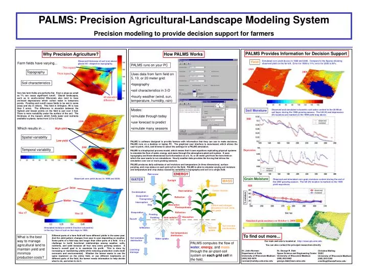
PALMS: Precision Agricultural-Landscape Modeling System Precision modeling to provide decision support for farmers PALMS Provides Information for Decision Support Why Precision Agriculture? How PALMS Works Simulated corn yield (bu/ac) in 1999 and 2000. Compare to the figures showing observed yield on the far left. Error for 1999 is 11%; error for 2000 is 39%. Observed thickness of soil (cm) above glacial till - draped on topography. Yield Farm fields have varying... PALMS runs on your PC Thin topsoil 1999 Topography 2000 Thick topsoil • Uses data from farm field on 5, 10, or 20 meter grid: • topography • soil characteristics in 3-D • hourly weather (wind, sun, temperature, humidity, rain) H Soil characteristics D Very few farm fields are perfectly flat. Even a slope as small as 1% can cause significant runoff. Glacial landscapes, such as in south-central Wisconsin also tend to have enclosed depressions which collect water in temporary ponds. Ponding and runoff cause fields to be wet in some areas and dry in others. This field in Arlington, WI is less than 5 acres. The difference in elevation between the highest and lowest points on the field is just over 4 feet. There is more variability under the surface of the soil. The thickness of the topsoil, which holds water and nutrients available to plants, varies from 2.5 to 6.5 feet. 4ft elevation difference • Modes: • simulate through today • use forecast to predict • simulate many seasons Soil Moisture Observed and simulated volumetric soil water content in the 30-90cm soil layer, during the 1999 growing season. The hill (H) and depression (D) locations are marked on the 1999 yield map above. Hill 1999 Which results in ... High yield Spatial variability Low yield PALMS is software designed to provide farmers with information that they can use to make decisions. PALMS runs on a desktop or laptop PC. The graphical user interface is Java-based, which allows the user to point, click, and browse to select the settings for a PALMS simulation. PALMS is a biophysical process model, which means that it uses equations replicating physical systems to simulate the flow of water, energy, and mass through the atmosphere-plant-soil system. It uses topography and three-dimensional soil information on a 5, 10, or 20 meter grid from the farm field on which the user wants to run simulations. Hourly weather data provides the forcing that drives the simulation over one or more growing seasons. PALMS produces daily estimates of soil moisture and temperature (in three dimensions), surface ponding, and crop status on each grid cell on the field. PALMS is able to simulate varying soil moisture and temperature and crop status caused by variability in topography and soil on a single field. 2000 Temporal variability Depression ENERGY Rain/snow Grain Moisture Observed corn yield (bu/ac) in 1999 and 2000. WATER Observed and simulated corn grain moisture content during the end of the 2000 growing season. The hill (H) location is marked on the 1999 yield map above. MASS Sunlight Hill Oxygen Drier Carbon dioxide Heat radiation Condensation Evaporation Reflection % moisture Transpiration Wetter Interception Drip Absorption Carbon and nitrogen allocation in root, stem, leaf, grain Photosynthesis Evaporation May 17 Reflection May 22 Oct 1st Ponding Absorption Heat radiation Puddling Runoff Simulated grain moisture on October 1, 2000 Soil microbebiochemistry Simulated moisture content (fraction volumetric) in the top 14cm of soil on two days in 1999. Infiltration Nutrient uptake Soil temperaturedistribution To find out more... Different parts of a farm field will have different yields in the same year. And the yield pattern changes from year to year depending on weather. Some parts of a field stay wet longer than other parts of a field. It is a challenge to build functional relationships among weather, soils, nutrients, and yield because all four vary every growing season. A farmer’s overall goal is to maximize his profit. This is done by increasing or maintaining yields while reducing production costs (both economic and environmental). Whether the farmer wants to use the same treatment on the entire field, or use different treatments on different parts of the field, the farmer needs information to help decide what to do, and when to do it. What is the best way to manage agricultural land to maintain yield and minimize production costs? Soil moisture distribution Water uptake Our main web site is located at http://resac.gis.umn.edu You can also contact the principal researchers directly PALMS computes the flow of water, energy, and mass through the air-plant-soil system on each grid cell in the field. Leaching/drainage Dr. John Norman Department of Soils University of Wisconsin-Madison (608) 262-4576 norman@calshp.cals.wisc.edu Dr. George R. DiakSpace Science and Engineering Center University of Wisconsin-Madison (608) 263-5862george.diak@ssec.wisc.edu Christine MollingSSEC University of Wisconsin-Madison (608) 265-5350cmolling@facstaff.wisc.edu