Download
1 / 47
480 likes | 1.37k Views
Ahead of the United Nations Climate Conference, Reuters released “Earthprints,” a series illustrating the human impact on the landscape. From sprawling urban growth to the construction of new islands, each site has profoundly changed in the last 30 years. Each featured location has accompanying NASA satellite images that show the scale of the change. The climate change summit (COP21) will be held in Paris from Nov. 30 - Dec. 11.--By Reuters

E N D
One of Europe’s biggest glaciers, the Great Aletsch, coils 23 km (14 miles) through the Swiss Alps - and yet this mighty river of ice could almost vanish in the lifetimes of people born today because of climate change. Mountain guide Christian Pletscher looks towards the Aletsch Glacier from the Jungfraufirn Glacier, Switzerland, Aug. 28. “When I was [my daughter’s] age, the Trient Glacier was about 500 metres from the hut,” he said. “Now the glacier is a long, long way away.” (Denis Balibous/Reuters)
Ice melts on the Aletsch Glacier in Fiesch, Switzerland, Aug. 12. The glacier, 900 metres (2,950 feet) thick at one point, has retreated about 3 km (1.9 miles) since 1870 and that pace is quickening. (Denis Balibous/Reuters)
The Aletsch Glacier is pictured in Riederalp, Switzerland, Aug. 23. The United Nations’ panel of climate scientists says sea levels are set to rise by between 26 and 82 cm by the late 21st century, after a gain of about 20 cm since 1900, partly fed by water from melting glaciers. (Denis Balibous/Reuters)
A close-up view of ice is pictured inside a glacier cave on the Aletsch Glacier in Fiesch, Switzerland, Aug. 29. (Denis Balibous/Reuters)
A goat rests at the Platta viewpoint as a group of hikers (background on R) trek in the distance on the Aletsch Glacier in Fiesch, Switzerland, Aug, 12. (Denis Balibous/Reuters)
Water from the melting glacier runs down through a hole in the Aletsch Glacier on the Jungfraufirn Glacier, Switzerland, Aug. 28, (Denis Balibous/Reuters)
The Aletsch Glacier in Switzerland is seen in a combination of NASA satellite images taken June 8, 2014 (top) and August 18, 1987 (bottom). (NASA via Reuters)
Lake Powell on the Colorado River provides water for Nevada, Arizona and California. A severe drought in recent years, combined with withdrawals that many believe are not sustainable, has reduced its levels to only about 42 percent of its capacity. A houseboat camps on the shore in shallow water in a canyon at Lake Powell near Page, Arizona, May 26. (Rick Wilking/Reuters)
Sandstone sculpted by water and wind erosion is seen in a slot canyon, one of hundreds that surround Lake Powell near Page, Arizona, May 26. (Rick Wilking/Reuters)
An area that would be under water if the lake was full, in Lake Powell near Page, Arizona, May 26. (Rick Wilking/Reuters)
A narrow slot canyon photographed from the air at Lake Powell near Page, Arizona, May 26. (Rick Wilking/Reuters)
Lake Powell in the United States shown in a combination of NASA satellite images taken in 1991 (L) and 2015 (R). (NASA via Reuters)
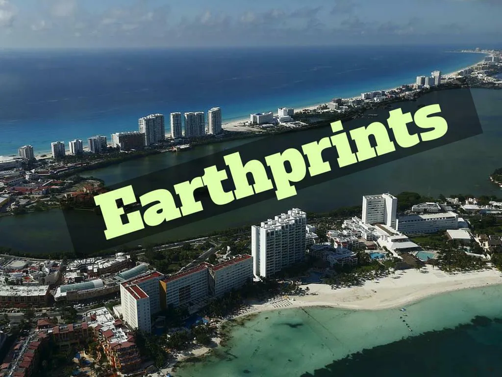
Cancun’s transformation in the 1970s from a small Caribbean fishing village into a strip of nightclubs and high-rise hotels has reduced biodiversity and polluted water resources as infrastructure struggles to keep up. A view of resort hotels in Cancun, Aug.13. (Edgard Garrido/Reuters)
A member of a bridal party looks at a bird fishing in the sea in Cancun, Oct. 14.The Mexican beach resort attracts more than 3 million tourists a year. (Edgard Garrido/Reuters)
A woman walks on a makeshift bridge near Sargassum algae in Puerto Morelos, near Cancun, Aug. 11. The Sargassum algae contains biting sand fleas and releases a pungent smell as it decomposes. It has choked beaches in resorts throughout the Caribbean including Cancun this season, prompting local authorities to launch a large-scale clean-up operation. (Edgard Garrido/Reuters)
Due to mass tourism, Mexico has already lost 65 percent of its mangroves, according to environmental group Greenpeace, with more disappearing with each passing year. A mangrove swamp in Cancun, Aug.1 (Edgard Garrido/Reuters)
A man walks on concrete blocks used for hurricane and Sargassum algae protection in Cancun, Aug. 14. Mangrove swamps, which form a natural barrier against hurricanes have been removed to make way for hotels and other buildings. Fewer mangroves lead both to coastal erosion and greater risk of damage when hurricanes strike, according to CEMDA, the Mexican Center for Environmental Law. (Edgard Garrido/Reuters)
The coastline of Cancun in Mexico is seen in a combination of NASA satellite images taken in 1988 (L) and in 2015. (NASA via Reuters)
The town of Rio Pardo, a settlement of about 4,000 people in the Amazon rainforest, rises where only jungle stood less than a quarter of a century ago. Loggers first cleared the forest followed by ranchers and farmers, then small merchants and prospectors. Brazil’s government has stated a goal of eliminating illegal deforestation, but enforcing the law in remote corners like Rio Pardo is far from easy. A family sits outside their house in Rio Pardo next to BomFuturo National Forest, in the district of Porto Velho, Rondonia State, Brazil, Sept. 1. (Nacho Doce/Reuters)
Sawmills that process illegally logged trees from the Amazon rainforest near Rio Pardo, in the district of Porto Velho, Rondonia State, Brazil, Sept. 3. (Nacho Doce/Reuters)
Men try to extinguish a fire at a farm in Rio Pardo next to Bom Futuro National Forest, in the district of Porto Velho, Rondonia State, Brazil, Aug. 30. (Nacho Doce/Reuters)
Cows roam on a deforested plot of the Amazon rainforest near Rio Pardo, in the district of Porto Velho, Rondonia State, Brazil, Sept. 3. (Nacho Doce/Reuters)
Rondonia, a western Brazilian state about half the size of Ireland, is seen in a combination of NASA satellite image taken July, 19, 1975 (L) and August, 27, 2014 (R). Deforestation of the rainforest in Rondonia in recent decades has gone ahead largely unimpeded. Since 1988, about 16 percent of the state has been cleared. An area bigger than Germany has been razed across the entire Amazon over the same period. (NASA via Reuters)
On a barren, sun-baked plateau in southern Spain, row upon row of gleaming mirrors form one of the world’s biggest solar power plants and harness the sun’s power even after dark. The Andasol solar power station near Guadix, southern Spain, Aug. 8. (Marcelo del Pozo/Reuters)
The sun reflects off a solar collector assembly during sunset at the Andasol solar power station near Guadix, southern Spain, June 30. The plant is the biggest solar farm in the world and provides electricity for up to about 500,000 people. . (Marcelo del Pozo/Reuters)
A worker drives among solar collector assemblies at the Andasol solar power station near Guadix, southern Spain, July 1. (Marcelo del Pozo/Reuters)
A view of a solar field at the Andasol solar power station near Guadix, southern Spain, July 1. The 620,000 curved mirrors harness the sun’s power even after dark, and the glass alone would cover 1.5 square km (0.6 square miles) - the size of about 210 soccer pitches. (Marcelo del Pozo/Reuters)
An area of southern Spain at the base of the Sierra Nevada mountains is seen in a combination of NASA satellite images taken in 1999 (L) before the construction of the Andasol solar power station and in 2014 (R) with the power plant clearly visible. (NASA via Reuters)
Ring-billed fulls gather at Tommy Thompson Park located on a man-made peninsula known as the Leslie Street Spit, in Toronto on June 24. It was created over 60 years ago by the dumping of dredged sand, concrete chunks and earth fill, expanding what was once just a thin strip of land in the city’s busy harbor. (Mark Blinch/Reuters)
Birds fly on the shores of Tommy Thompson Park located on a man-made peninsula known as the Leslie Street Spit, in Toronto, May 24. An unexpected urban oasis, the development brings marshes, lagoons and forests to the centre of Canada’s largest city. (Mark Blinch/Reuters)
A painted turtle sits on a log at Tommy Thompson Park located on a man-made peninsula known as the Leslie Street Spit, in Toronto, June 24. (Mark Blinch/Reuters)
People look out at the Toronto skyline from Tommy Thompson Park located on a man-made peninsula known as the Leslie Street Spit, in Toronto, Aug. 9. (Mark Blinch/Reuters)
An eastern cottontail rabbit hides in the grass at Tommy Thompson Park located on a man-made peninsula known as the Leslie Street Spit, in Toronto, June 24. (Mark Blinch/Reuters)
Leslie St Spit in Toronto Canada is seen in a combination of NASA satellite images taken August 21, 1972 (L) and August 22, 2015 (R). The Spit was created over 60 years ago by the dumping of dredged sand, concrete chunks and earth fill, expanding what was once just a thin strip of land in the city’s busy harbor. (NASA via Reuters)
A park ranger surveys damage caused by flooding at Lake Nakuru National Park, Kenya, Aug.18. The Park is home to some of the world’s most majestic wildlife including lions, rhinos, zebras and flamingos. UNESCO says that with rapid population growth nearby, the area is under “considerable threat from surrounding pressures,” particularly deforestation, a contributing factor in floods. (Joe Penney/Reuters)
The neck of a giraffe that resides at Lake Nakuru National Park, Kenya, Aug. 19. (Joe Penney/Reuters)
Nakuru town encroaches Lake Nakuru National Park, Kenya, Aug. 18. UNESCO says that with rapid population growth nearby, the area is under “considerable threat from surrounding pressures,” particularly deforestation, a contributing factor in floods. (Joe Penney/Reuters)
A lion cub rests in the grass at Lake Nakuru National Park, Kenya, Aug. 19. The scenery is stunning, from forests of acacia trees to animals congregating at the shores to drink. (Joe Penney/Reuters)
Flamingos gather next to trees damaged by flooding at Lake Nakuru National Park, Kenya, Aug. 20. The normal area of the lake was 31 square km in 2010 and it swelled to 54 square km in 2013. In late 2014, it started receding but not quickly enough to return to the 2010 levels. (Joe Penney/Reuters)
A hyena eyes a herd of zebra at Lake Nakuru National Park, Kenya, Aug.19. (Joe Penney/Reuters)
Lake Nakuru National Park is seen in a combination of NASA satellite images taken September 9, 1972 (L) and July 7, 2015 (R). The contrast in the landscape around the lake is clearly visible with many more homes and fewer trees now. (NASA via Reuters)
Vistors look out at the skyline from a rooftop bar in the central business district in Singapore July 24. When Singapore celebrated its 50th birthday as an independent country in August, the city state bore little resemblance to the tiny island nation that was expelled from Malaysia in 1965. Its physical stature has swollen by 20 percent thanks to one of the world’s most aggressive land reclamation drives. (Edgar Su/Reuters)
An aerial view of a manmade beach and oil refineries in Pulau Bukom, an island built on reclaimed land, Nov. 5. (Edgar Su/Reuters)
People enjoy a picnic on the Marina Barrage, which houses the pump house of the urban Marina Bay reservoir, Singapore, Aug. 7. (Edgar Su/Reuters)
Commuters walk to the train station during evening rush hour in the financial district of Singapore March 9. (Edgar Su/Reuters)
Singapore is seen in a combination of NASA satellite images taken in 1973 (L) and 2014 (R). Its physical stature has swollen by 20 percent thanks to one of the world’s most aggressive land reclamation drives. (NASA via Reuters)