Download
1 / 10
100 likes | 265 Views
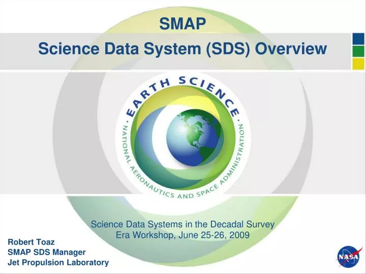
SMAP Science Data System (SDS) Overview. Science Data Systems in the Decadal Survey. Era Workshop, June 25-26, 2009. Robert Toaz SMAP SDS Manager Jet Propulsion Laboratory. Overview of Presentation. Mission Overview End-to-End Data Flow Diagram Key Driving SDS Design Requirements

E N D
SMAPScience Data System (SDS) Overview Science Data Systems in the Decadal Survey Era Workshop, June 25-26, 2009 Robert Toaz SMAP SDS Manager Jet Propulsion Laboratory
Overview of Presentation • Mission Overview • End-to-End Data Flow Diagram • Key Driving SDS Design Requirements • Science Data Product Suite • SDS Architecture & Functional Diagram • Algorithm-to-Production Software Process • Data Storage and Archive Strategy
SMAP Mission Overview • Objectives: • Provide global measurements of soil moisture with the accuracy, resolution, and coverage to improve our understanding of hydrologic cycle • Orbit: • Sun-synchronous, 6 am/pm orbit, 8 day repeat • 680 km altitude • Instruments: • L-band (1.26 GHz) radar • High resolution, moderate accuracy soil moisture • Freeze/thaw state detection • SAR mode (non-imaging): 3 km resolution • Real-aperture mode: 30 x 6 km resolution • L-band (1.4 GHz) radiometer • Moderate resolution, high accuracy soil moisture • 40 km resolution • Shared instrument antenna • 6-m diameter deployable mesh antenna • Conical scan at 14.6 rpm • Incidence angle: 40 degrees • Creates contiguous 1000 km swath • Swath and orbit enable 2-3 day revisit • Mission Operations: • 3-year baseline mission, 2014-2017
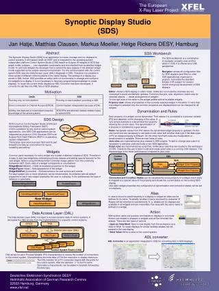
SMAP End-to-End Data Flow Legend SMAP NASA-Supplied Project-supplied S-Band TDRS Network S-Band External Data Archive & Distribution (DAAC) Critical Event Coverage S-Band, X-Band S-Band SDS MOS/GDS Validated Science Data Products TDRSS Earth Terminal NASA Ground Station L0 Data Information Management Life-of-Mission Data Storage Project & Instrument Team Data Access Radar and Radiometer Telemetry L0 Processing Science Data Analysis GSFC Comm Cloud Cmds Plb HK RT HK RT & Plb HK Plb HK Flight Ops Monitoring & Control L1 Science Data Products L3, L4 Science Data Products S/C Provider S/C Cmds Radiometer and Radar Data Processing Geophysical Data Processing Instrument Cmds Instrument Monitoring Science Data Processing Realtime (RT) & Playback (Plb) HK
Key/Driving SDS Requirements • Data Acquisition Volumes: 45 GBytesper day • Data Product Types:Level 0 (2), Level 1 (4), Level 3 (4), Level 4 (2) • Three year Life of Mission Storage: All Science Data Products (~ 80 TBytes) • Reprocessing: 30 months of data in 12 months • Data Product Latency (post-Commissioning): • Level 0/1 12 hours from data acquisition • Level 3 24 hours from data acquisition • Level 4 7–14 days from data acquisition • Initial Release to DAAC of Science Team Validated Products: • Level 0/1 begins 6 months after commissioning • Level 3 begins 12 months after commissioning • Level 4 begins 12 months after commissioning • Data Product Accuracy for Level 1: • Geolocation accuracy of less than 1 km for L1C_SO_HiRes • Sigma0 accuracy of 1 dB or less for Radar L1 (3km resolution) • Brightness temperature accuracy of 1.3 degrees K or less for Radiometer L1 • Ops Performance Margin: 50% • Testbed Capability: support algorithm and production software development/processing, and ingestion of field campaign data
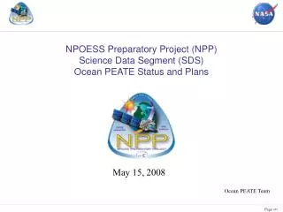
Global Mapping L-Band Radar and Radiometer High-Resolution and Frequent-Revisit Science Data Observations + Model Value Added Product SMAP Science Data Products
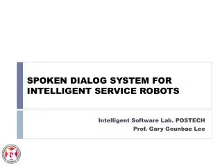
Distributed Users SDS Architecture and Functional Diagram External JPL GSFC SDS Ground System Network L4 PGEs L0 Radiometer PGE L1 Radiometer PGEs S/C HK, Science TLM, Tracking Data L4 L1, L3 L1 L0b L0a L0b Provisional Products Project and Science Team Users MOS/GDS Processing Control & Life-of-Mission Storage Validated Products S/C HK, Ephemeris, Time Correlation Data, L0a Radar/Radiometer, Ground truth, Ancillary data Data Archive & Distribution Center L1, L3, L4 L0B L0A Performance Reports L1 L0B L3 L1 L0 Radar PGE Science Data Analysis L1 Radar PGEs L3 PGEs PGE – Product Generation Executable
Algorithm-to-Production Software Process Testbed and Operational System Share Identical Architecture Algorithm Software Formulation & Prototyping ATBDs Algorithm Software Delivery Review Production Software Development - Single Executable Testing - Multiple Executable Pipeline Testing - System I&T Production Software Release Review SDS Testbed SDS Operational System Production Software Deployment ATBD – Algorithm Theoretical Basis Document
Algorithm Software Delivery Process • All algorithm software deliveries will be in Fortran, C, and/or C++ • Algorithm prototyping software (in IDL and MATLAB) will support algorithm software deliveries to the SDS • All delivered software will adhere to the “Algorithm Software Coding Specification” document • Supporting material in algorithm software deliveries includes: • Algorithm Inputs (ancillary datasets, parameter specifications, …) • Algorithm Outputs (expected numeric results, success criteria, …) • Test datasets • Algorithm software deliveries will be phased with Production Software releases containing the delivered algorithm software • Algorithm software delivery schedule must align with the Project schedule through Phases B, C, and D
Data Storage and Archive Strategy Life-of-Mission Storage Provides readily accessible Mission data to Project teams throughout the Mission SDS Operational System SDS Testbed • Production Data Storage • Ancillary data • L0 Radar, Radiometer • L1B/C Radar, Radiometer • L3 Soil Moisture, Freeze/Thaw • L4 Soil Moisture, Carbon • Test Data Storage • Field campaign results • Cal/Val datasets • Simulation data Long-term Archive Provides validated Science Products beyond the Project Team DAAC • Production Archive • Ancillary Data • L0 Radar, Radiometer • Validated L1B/C Radar, Radiometer • Validated L3 Soil Moisture, Freeze/Thaw • Validated L4 Soil Moisture, Carbon