Download
1 / 28
280 likes | 405 Views
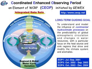
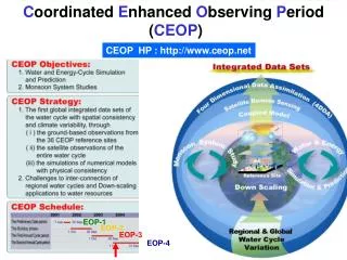
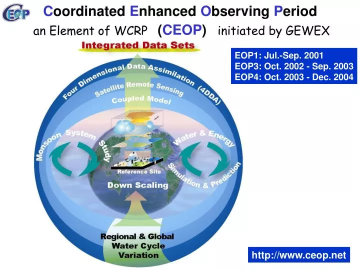
C oordinated E nhanced O bserving P eriod ( CEOP ). an Element of WCRP. initiated by GEWEX. EOP1: Jul.-Sep. 2001 EOP3: Oct. 2002 - Sep. 2003 EOP4: Oct. 2003 - Dec. 2004. http://www.ceop.net. CEOP SCIENTIFIC OBJECTIVES. LONG-TERM GUIDING GOAL To understand and model

E N D
Coordinated Enhanced Observing Period (CEOP) an Element of WCRP initiated by GEWEX EOP1: Jul.-Sep. 2001 EOP3: Oct. 2002 - Sep. 2003 EOP4: Oct. 2003 - Dec. 2004 http://www.ceop.net
CEOP SCIENTIFIC OBJECTIVES LONG-TERM GUIDING GOAL To understand and model the influence of continental hydroclimate processes on the predictability of global atmospheric circulation and changes in water resources, with a particular focus on the heat source and sink regions that drive and modify the climate system and anomalies. OVERALL OBJECTIVE 2 Document the seasonal march of the monsoon systems, assess their living mechanisms, and investigate their possible physical connections. CEOP Intern-Monsoon Study (CIMS) OVERALL OBJECTIVE 1 To better document and simulate water and energy fluxes and reservoirs over land on diurnal to annual temporal scales and to better predict these on temporal scales up to seasonal for water resources application. Water & Energy Simulation & Prediction (WESP)
Coordinated Enhanced Observing Period Three Unique Capabilities Convergence of Observations A Prototype of the Global Water Cycle Observation System of Systems
CEOP Reference Sites Data Release Guidelines Data exchange guidelines: • To comply with WMO Resolutions 40 (CG-XII) and 25 (CG- XIII) in particular: No financial implications. (2) CDA and data users: Commercial exploitation of CEOP data is prohibited. (3) Data users: No transfer to third parties. (4) Data release to data users: Turn-around period. Category 1 data: 6 months Category 2 data: 15 months (5) Acknowledgement and citation (6) Co-Authorship for Reference Sites’ PIs recommended, collaboration base required if PI requests co-authorship (in particular for category 2 data) (7) CEOP Publication Library at CDA Hans-Jörg Isemer, International BALTEX Secretariat, isemer@gkss.de
Soil 250km RS 250km Rain TB Water Vapor 3 Types scale of Satellite datasets 2.Monsoon Region 1.Reference site:35 Points >North Africa >Australia >South America >North America >Asia 3.Global
Model Data Content (as of 6 February 2007) 4.324 TByte The most recent version of the data status (time line) can be found from: http://www.mad.zmaw.de/wdc-for-climate/ceop/
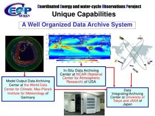
In-Situ Data Archiving Center at NCAR (National Center for Atmospheric Research) of USA Model Output Data Archiving Center at the World Data Center for Climate,Max-Planck Institute for Meteorology of Germany Data Integrating/Archiving Center at University of Tokyo and JAXA of Japan Coordinated Enhanced Observing Period Three Unique Capabilities Interoperability ArrangementA well organized collecting, processing, storing, and disseminating shared data, metadata and products
Metadata standard development framework • Metadata implementation model • Web service application ISO19139 Metadata-implementation • Metadata conceptual model OGC WFS,WCS,CTS ISO 19115 metadata • Application requirements
Reference Site EOP-3/4 Data Flow Data Source Data/Doc Arrive at EOL Apply Auto/Manual Data/Doc Consistency Checks Generate Flagging and Site Statistics Gross Limit Checks Format Verification Data/Flag/Doc Checks Exact/Inexact Dup Records Visual Inspection of Data and Plots EOL Updates Status Table and Detailed Notes Merge Data Available On-Line
GrADS/ DODS for Subsets GrADS/ DDDS for Subsets Distributed Integration Services UCAR Computing Power In-situ model In-situ model In-situ model Centralized Integration Services In-situ In-situ In-situ model In-situ model http://jaxa.ceos.org/wtf_ceop/ MPI GrADS/ DODS for Subsets model http://monsoon.t.u-tokyo.ac.jp/ceop-dc/ceop-dc_top.htm satellite satellite satellite satellite UT/JAXA Computing Power satellite satellite satellite Coordinated Enhanced Observing Period Three Unique Capabilities Data ManagementDistributed- and Centralized- Data Integration Functions
WTF-CEOP Distributed Data Integration System Users User client – data download and analysis User client – Library of scripts Web Browser • Locate Data • Visualize Data • Light Processing UCAR Archive (In-situ) D O D S MPI Archive (Model Output, MOLTS) D O D S WTF-CEOP Live Access Server (LAS) D O D S CSDIC Archive (Satellite, Model Output) Ferret IDL CDAT GrADS Matlab D O D S Other Data Archives
User Web Browser / Client Application HTTP Server Data Integration Engine Visualization Engine Data Mining Engine DBMS Storage Management System Hierarchical Storage Management Centralized Data Integration Functions
GCM Satellite Data Reference site data
Minimization Scheme GCM Forcing Satellite Data Land Surface Scheme Radiative Transfer Model Cost Function LDAS Validation Intercomparison Reference site data
Input Data High Applicability in Any Region • LDAS-UT grid size: 0.5 degree • Forcing • GPCP precipitation: 1 degree • ISCCP radiation: 2.5 degree • NCEP reanalysis: 1.5 degree • Leaf area index: MODIS • Microwave Tb: AMSR-E
LDASUT- GCMs Seasonal variation (May - September) Sensible(H) - Latent(LE) - NCEP OBS 1998 (2003 unavailable) LDASUT JMA UKMO LE daily-mean ( June) Observed Modeled
Seasonality of distributed Bowen Ratio: Sensible Heat Flux/Latent Heat Flux LDAS Seasonality: May~Mid June, H > lE; Mid June~Aug; lE>H LDAS Regionality: H is dominant in N.W. TP, lE is dominant in S.E. TP LDASUT NCEP
Minimization Scheme GCM Land surface impacts on prediction Forcing Satellite Data Land Surface Scheme Radiative Transfer Model Cost Function LDAS Validation Intercomparison Reference site data Validation
Impacts of the Tibet surface initial conditions on the GCM prediction of the surface parameters (UT-JMA Cooperative Research) sensible heat flux latent heat flux surface temperature Use the assimilation product as the initial condition Nighttime 3 Day Prediction Daytime
Impacts of the Tibet surface initial conditions on the GCM prediction of the precipitation (UT-JMA Cooperative Research) Control FT 54 FT 60 FT 66 FT 72 Anal UT Similar Rainfall Pattern but Stronger Rainfall Intensity
GCM Physical Down-scaling Regional Model Land surface impacts on prediction Forcing Minimization Scheme Satellite Data Land Surface Scheme Radiative Transfer Model Cost Function GCM Validation Reference site data
(Surface perspective) soil moisture Assimilation No Assimilation
(Atmospheric perspective) No Assimilation case Assimilation case GMS IR1-based convective Index Vertical Wind field Vertical Wind field
Radar at BJ With Land Assimilation Without Assimilation 9-15 16-22 23-04
cold Regional Model high- elevation Global Model monsoon semi-arid HAP NWPCs/ACs NCEP,JMA ECPC,BoMUKMO,CMC ECMWF CPTEC NCMWF EPSON MET GMAO GLDAS Societal Benefits webs Land Surface Model/LDAS cross- cutting aerosol isotope extreme A Project of Projects Satellite data CEOS JAXA NASA ESA NOAA EUMETSAT WGISS WGCV WDC-C MPI-M NCAR/EOL UT&JAXA Reference Sites River basins Global Dataset Projects DATA INTEGRATION & ANALYSIS Centralized System U. Tokyo Distributed System WTF-CEOP